NOAA is talking about a big storm clobbering Lake Tahoe, CA this weekend. Open Snow is talking about it bringing up to 4-feet of snow.
We need this storm bad because there is no snow in Tahoe right now. This storm could be the key to getting ski resorts open in Tahoe. After this potential storm, it looks like high pressure will build back in. We need this storm, people!
Just to give a general idea 6-7 days out, the GFS and European forecast models are showing enough liquid for 1-2 feet at lake level and 2-3 feet on the mountains with up to 4 along the crest. – Opensnow.com
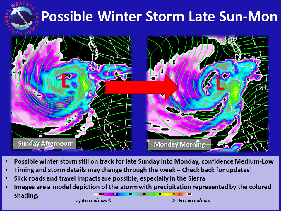
There is still a decent chance for a winter storm to push into the west at the end of the Thanksgiving holiday weekend. Current forecast models are indicating the main impacts will be late Sunday into Monday. Forecaster confidence is currently medium for a storm pushing into the west, but low regarding timing and storm details, which are likely to change through the week as we get closer to the event. There is the potential for slick roads and travel impacts especially in the Sierra and snow levels may drop below 5500 feet. Check back for the latest updates! – NOAA.gov
kirkwood weather says 2-3ft on the crest !!!!!!!
Stop trying to hype up the snow totals!!! Its just lame!
Not sure why y’all posted this, when the NOAA local long range today says this: LOW PRESSURE MOVES ONSHORE FRIDAY AFTERNOON AND EVENING BRINGING
GUSTY WINDS TO THE SIERRA FRONT WITH BREEZY CONDITIONS IN THE
SIERRA. THERE HAVE BEEN SOME INDICATIONS THAT DOWNSLOPING WILL BE
POSSIBLE. ALSO, WARMER SURFACE TEMPERATURES WILL PROMOTE INCREASED
MIXING OF FASTER WINDS ALOFT TO THE SURFACE. THEREFORE, INCREASED
WINDS FOR THE SIERRA FRONT ON FRIDAY AND SATURDAY WITH GUSTS FROM
35 TO 45 MPH. LOCALLY, WIND GUSTS MAY EXCEED 50 MPH ESPECIALLY IN
THE MORE WIND PRONE LOCATIONS. MOISTURE WILL DAMPEN THE WINDS
INTERMITTENTLY IN THE SIERRA AND NEVADA SIERRA FRONT AS A 140 MPH
JET PUSHES ACROSS FRIDAY EVENING INTO SATURDAY. WINDS WILL REMAIN
BREEZY TO GUSTY UNTIL THE FRONT PASSES LATER SATURDAY AFTERNOON.
A DECENT MOISTURE PLUME WILL ACCOMPANY THIS SYSTEM WITH A BROAD
SWATH OF PWATS GREATER THAN 1″ DIRECTED TOWARDS THE SIERRA. SNOW
LEVELS WILL REMAIN AT OR ABOVE 7000 FEET THROUGH SATURDAY MORNING
BEFORE COLDER AIR WORKS ITS WAY ACROSS THE SIERRA INTO THE NEVADA
INTERIOR. IMPACTS WILL BE LIMITED TO MAINLY WET ROADS WITH HIGHER
ELEVATION ACCUMULATIONS OF WET SNOW. TRAVELERS OVER SIERRA PASSES
SHOULD BE PREPARED FOR WINTER CONDITIONS AS ROAD SURFACES BECOME
SLICK. SNOW TOTALS WILL GENERALLY BE UP TO 5 INCHES. LIQUID
AMOUNTS WILL TAPER QUICKLY FROM THE SIERRA INTO WESTERN NEVADA DUE
TO TYPICAL SHADOWING. WE`RE CURRENTLY EXPECTING STORM TOTALS IN
THE 0.2-0.5″ IN THE SIERRA AND UP TO 0.1″ IN WESTERN NEVADA.
NORTHERN WASHOE, NORTHERN LASSEN, AND EASTERN MODOC COUNTIES MAY
PICK UP LOCALLY HIGHER TOTALS; UP TO 0.2″ POSSIBLE. BOYD
.LONG TERM…SUNDAY THROUGH WEDNESDAY…
THE 00Z ECMWF HAS BACKED OFF FURTHER WITH LOW NEXT WEEK AND NOW
PAINTS A MORE DISMAL PICTURE FOR A BIG STORM HITTING THE REGION.
IT NOW HAS A SHORTWAVE RIDGE OVER THE AREA ON TUESDAY FOLLOWED BY
MUCH WEAKER PRECIPITATION SIGNALS MID-LATE NEXT WEEK AS JET ENERGY
IS WEAKER AND FURTHER SOUTH. THE GFS STILL HAS THE UPPER LOW
MOVING INLAND BUT HAS SLOWED AS WELL WITH JET ENERGY COMING IN
FURTHER SOUTH TUE-WED. ITS QPF SIGNAL IS NOT AS IMPRESSIVE
COMPARED TO PREVIOUS DAYS. IN ADDITION, SNOW LEVELS ARE A BIT
HIGHER AS A RESULT WITH 700MB TEMPS GETTING NO COLDER THAN ABOUT
-4C OR -5C. THESE TRENDS ARE NOT SURPRISING BASED ON THE
DECREASING MODEL HEIGHT FORECASTS TO THE SOUTHWEST OF PARENT UPPER
LOW IN THE PACIFIC OVER THE PAST WEEK IN THE GFS WHICH IS TOWARD
THE MORE DRAMATIC SHIFT WEST IN THE ECMWF OF THE PAST COUPLE DAYS.
FOR SUNDAY, A NORTHERN STREAM SHORTWAVE WILL BE PASSING TO THE NORTH
WITH A WEAK FRONTAL BOUNDARY OVER NORTHERN NV-NORTHEAST CA. A MOIST
FLOW AND WEAK SHORTWAVE ENERGY WILL KEEP RAIN AND HIGH ELEVATION
SNOW GOING FOR THE NORTHERN SIERRA AND PARTS OF NORTHWEST NV. PRECIP
AMOUNTS DO NOT LOOK VERY IMPRESSIVE WITH SNOW LEVELS IN THE VICINITY
OF 6500-7000 FEET. THE ECMWF IS WETTER DURING THIS TIME FRAME
SHOWING 0.50-0.75 INCHES OF QPF SUNDAY ALONG THE CREST WITH SOME
LIGHT RAIN SPILLING INTO WESTERN NV. THERE COULD BE SOME SLICK ROADS
OVER THE HIGHER PASSES AROUND TAHOE EARLY SUNDAY AND AGAIN SUN NIGHT
AND MON MORNING. HOWEVER, DUE TO RELATIVELY HIGH SNOW LEVELS AND
DAYLIGHT HOURS, ROADS SURFACES WOULD LIKELY BECOME WET OVER THE
PASSES FOR THE LATE MORNING THROUGH MID AFTERNOON TIME FRAME SUNDAY
AND MONDAY. WE HAVE MAINTAINED OUR HIGHEST POPS ALONG THE SIERRA
SUN-MON.
FOR TUE-WED, WE HAVE REMOVED ANY MENTION OF LIKELY POPS FOR NOW DUE
TO THE WIDE RANGE OF POSSIBILITIES. A GENERAL CHANCE FOR RAIN AND
MOUNTAIN SNOW WAS USED UNTIL WE CAN GET A MORE SOLID SIGNAL FROM THE
MODEL SUITES. IF THE ECMWF IS CORRECT, IT WOULD BE DRY FROM MON
AFTN-WED MRNG. SUFFICE IT TO SAY, CONFIDENCE IS LOW. HOHMANN
flip flopping back today- a foot this weekend and another foot mid week with slightly higher snow levels next week, so hopefully 2-3 feet on the crest and probably that sticky crap that is good for base
at this point if ever does actually happen i still won’t believe it
Believe or not, changes are evident in global weather patterns due to 2011 earthquake in Japan.
https://axischange.wordpress.com/
Every time the ‘Brainers’ post amount totals of predicted storms, totals always fall far short. WTF?
Stop putting the jinx on storms and even if NOAA says how much, please refrain from jinxing it.
Old school used to be, never, ever talk about it,,,,,be nice to see some of that humility again these days.
Happy Turkey Slaughter day everyone…
Like many folks “I’ll believe it when I see it!” Lol. Still had a blast during opening weekend at northstar was fun to get back out there. I will definitely be back up Dec 1st to chk this! Thanks