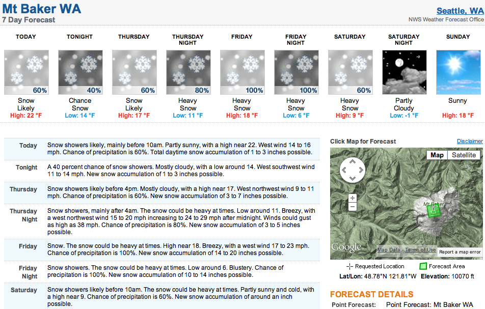
The snow must be getting deep up on 10,781-foot Mt. Baker in Washington state. In the end of September, Mt. Baker got 13 feet of snow in 4 days. Just last week, Baker got 50” of snow in 4 days. The forecast today is showing 53” of snow for Mt. Baker in the next 4 days…
Mt. Baker ski resort has 22” forecasted for its 3,900-foot level elevation in the next 4 days which ain’t too shabby, either. Baker is planning to open as soon as they have enough snow to do so. Could this be the storm that opens Baker? Lets hope so.
What’s great about this storm, is that it’s going to be cold. Snow levels are forecasted to be near sea level beginning Saturday. A cold airmass will be coming down directly from Canada to make things chilly and snowy.
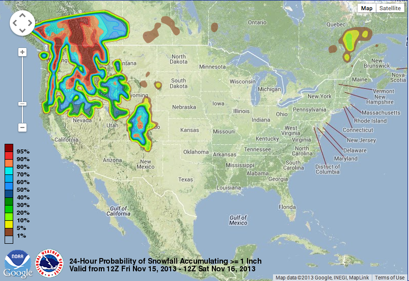
THE SNOW LEVELS WILL FALL TO NEAR SEA
LEVEL ACROSS THE NORTHEAST PART OF THE CWA AND TO NEAR 2000 FEET
ACROSS THE SOUTHWEST PART. SUNDAY AND MONDAY MORNINGS WILL BE QUITE
CHILLY. - NOAA FORECAST DISCUSSION, 337AM PST WED NOV 13 2013

NOAA’S MT. BAKER FORECAST DISCUSSION:
LOOK FOR A MUCH STRONGER LOW PRESSURE SYSTEM TO IMPACT THE PACIFIC
NORTHWEST ON FRI FOR LOCALLY WINDY CONDITIONS AND A PERIOD OF
HEAVY SNOW DUE TO OROGRAPHIC ENHANCEMENT IN THE MOUNTAINS…
ESPECIALLY THE CASCADES. TOTAL SNOWFALL AMOUNTS ARE EXPECTED TO
COME CLOSE TO WARNING CRITERIA…SO LATER SHIFTS WILL NEED TO
DECIDE WHETHER A WINTER STORM WATCH WILL BE NEEDED FOR FRI. THE
ASSOCIATED COLD FRONT WILL SWEEP ACROSS THE CWA FRI NIGHT AND
USHER IN A COLDER AIR MASS.
One thought on “53” of Snow Forecasted for Mt. Baker, WA in Next 4 Days…Again!”