“Confidence continues to grow that this El Niño will be one of the stronger El Niños over the past 50 years. El Niño typically reaches its peak during the December through February period.” – AccuWeather Senior Meteorologist Brett Anderson
“THIS IS GOING TO BE THE STRONGEST EL NINO ON RECORD.” – WeatherBrains
“This is much stronger than we’ve seen—this is the biggest signal since 1997. Not a puny El Niño but a Godzilla El Niño.” – Bill Patzert, a climatologist at NASA’s Jet Propulsion Lab in Pasadena, CA
El Nino is strengthening and on track to be the strongest El Nino we’ve ever recorded. This could likely be the very thing that California needs to break its 4 year drought and bury the Sierras in deep snow this coming winter.
NOAA just released their latest El Nino update today and they are saying that there is now greater than a 90% chance that the current El Nino will continue through our Northern winter 2015/16. They’re also saying that there is an 80% that the current El Nino will continue through Spring 2016.

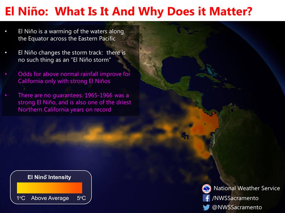
California has received above average precipitation 4 out of the last 5 Strong El Nino’s on record. That’s a small sample size, but from that small sample size, California saw above average precipitation 80% of the time.
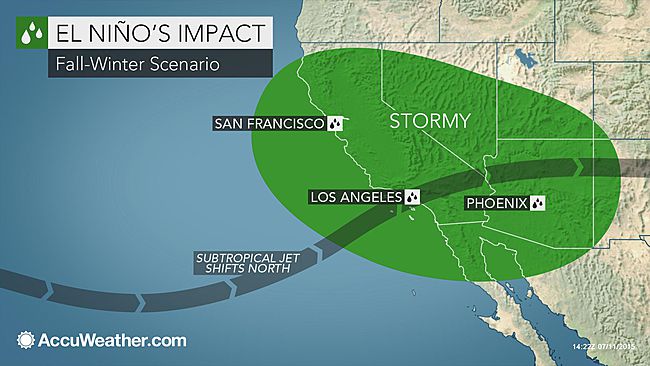
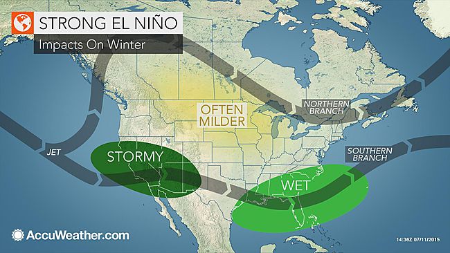
“A strong El Niño could be good news for the extreme drought in California. Unfortunately, a sudden turn to a stormy winter could also result in dangerous mudslides and flash flooding for the state.” – AccuWeather Senior Meteorologist Brett Anderson
California’s main problem during the last 4 years is the Ridiculously Resilient Ridge (RRR). The RRR has sat to CA’s northwest and has blocked any storms from coming in for 4 years. El Nino most likely will break down that ridge and bring us a pattern change. At this point, any change is a good change. We’ve got our fingers crossed for a big winter in California this year. Bye bye Japan… Hello California!
TECHNICAL MUMBO-JUMBO ABOUT THE BUILDING EL NINO FROM WEATHERBRAINS:
“Meteorologists are claiming this last storm one of the biggest storms to hit the Andes in 5 years. It was the the second atmospheric river (AR) this year, except this one became confluent with cold air and had a really strong short wave embedded in it at the tail end of the AR. It’s crazy to see these rivers in SA, they are not as common. Transition pattern looks like a good one for loche on the 17th, which also affects LL 18th or 19th. More storms beyond that.
“The jet stream in South America is always split with the southern stream usually the strongest. Not this year so far, the northern stream is raging. Ridge over Eastern Australia and or Tazmania with low pressure over Tahiti=Negative SOI (Southern Oscillation Index). MJO off the charts strenght wise in July (crazy)… Antarctica ridge specifically over the Bellingshaussen Sea right now.
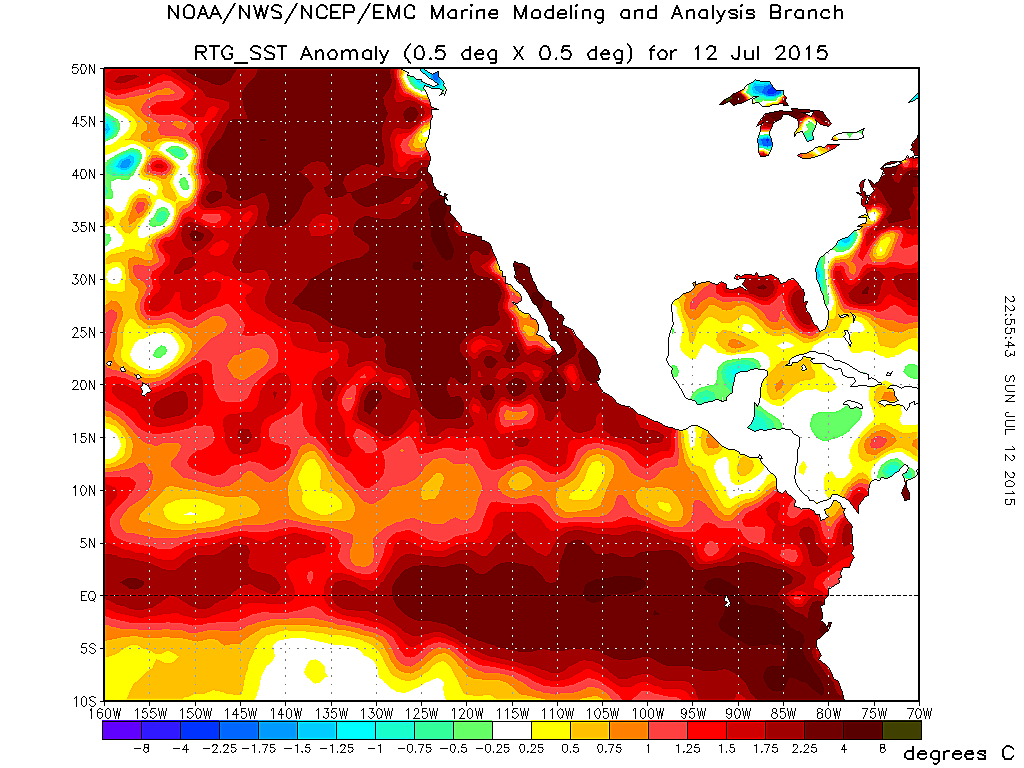
These are ALL SIGNATURE SIGNS OF “El Nino.” With the stronger northern stream it displaces the positioning of the ridges in the Pacific that consistently set up in between the two jet streams as a constant. With the positioning of the ridging further east it eliminates the block that would prevent these type of AR events like this last storm. This last atmospheric river had numerous short waves (impulses) embedded inside it. The river extended clear to 150W, clear to Tahiti (insane). The strength of the northern stream is directly related to the El Nino base state (1.5 degree C anomalies).
Possibly the strongest Kelvin Wave since March. A major westerly wind burst fueled by this (off the chart) MJO right in the Kelvin Wave generation zone. So another strong KW likely forming. That would be enough hot water to super feed the pipe clear through November if not January depending on how massive it becomes.
California is going to go from 1000 year drought to the 500 year flood with a couple 100 year floods mixed in for good measure. Truly who knows, but my educated guess is with the timing of this MJO it will tell the tale. If it goes into a strong inactive phase in the Pacific that would not follow an El Nino base state pattern, we could lose a lot of traction. If the MJO just fizzles out and then regains traction in the Pacific like 2 out of the 3 models suggest then we would probably be setting up for another strong westerly wind burst, tropical cyclone activity on both sides of the equator, setting the stage for the final KW that would MOST DEFINITELY send us into super El Nino status. We already have a strong base state. The atmosphere is coupling. LL and Chile in the 40-30 degree favored latitudes are by no means close to done. What just happened that was just the beginning, and by no means will end up a fluke as far as this season goes. So that being said, I am very certain THIS IS GOING TO BE THE STRONGEST EL NINO ON RECORD THE 3.4 REGION WILL EXCEED 2.2 DEGREES C.
“SUPERBOY 2015″….
Most important to me is what just happened a sign of all signs. Once again THIS IS JUST THE FUCKING BEGINNING!!!!
The yearly polar vortex horseshoe jet stream will block 2015/16 Godzilla El Niño’s storms from reaching western US, drought will continue over west coast and Rockies. The polar vortex even warms up and dries out Alaska often to truly say its impact is the total western US. Eastern US will see return of deep freeze and eastern US will bear brunt of El Niño snow as it rides the blocking pattern Northward over the pole and down to Easter US. Polar vortex is not a wave pattern but a locked in place bend of jet stream with powerful high altitude ridge of high pressure. The cause increasingly being understood as due to new solar minimum. There’s growing investigation into nefarious technology, patents for EM atmospheric manipulation exist but difficult to detect if it is occurring and by whom.
Well, once again, we are anticipating storms that will bring a deluge of water and we have not built any structures that can hold the water for later use. Most of this water will be rambling down to the ocean and because of the dry, cement-like conditions of the earth, it will roll off until it saturates the ground and then cause damage with mudslides. Why don’t we have reservoirs that hold this water for later use? Where are our community leaders planning for these winters of unprecedented rainfall? We, as a planet are doomed if we continually just react and never plan. Science deniers and haters abound and meanwhile the good people who would like to do something are stymied and lack organization, money and commitment. I guess we all get what we deserve.
bring it!
woooooooooooooooooooooohooooooooooooooooooooooo
BRING IT!!!!