NOAA just upgraded the current storm in northern California from a Winter Weather Advisory to a Winter Storm Warning for the west slope of the Sierra Nevada and Sierra Crest. A Winter Weather Advisory still exists for the Tahoe Basin, much of the east slope of the Sierras, and the southern Sierra Nevada. NOAA is now calling for 4-8″ above 4,000-feet & 12-16″ above 8,000-feet with snow levels as low as 3,000-feet (see image).
This is the second time NOAA has upgraded the snow totals for this storm.
“Heavy precipitation expected today as this storm continues to impact NorCal through early Tuesday. We have upgraded the Sierra to a Winter Storm Warning above 4000 ft elevation and we still have concerns for flash flooding at wildfire burn scars.” – NOAA Sacramento, CA
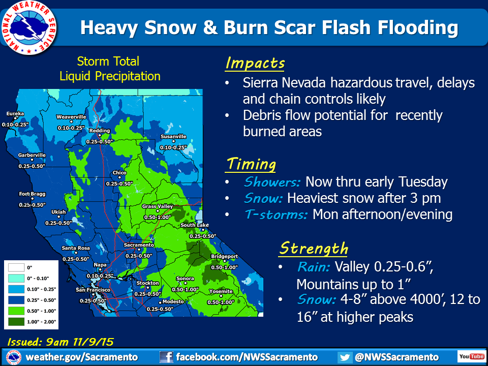
NOAA is now calling for 12-16″ of snow on the Sierra Crest with locally higher amounts.
* SNOW ACCUMULATIONS...4 TO 8 INCHES WITH 12 TO 16 INCHES ALONG
  THE CREST. - NOAA Reno, NV today
Snow levels are forecast to be as low as 3,500-feet with this storm.
* SNOW LEVELS...3500 TO 4000 FEET. - NOAA Reno, NV today
Mammoth, Boreal, and Mt. Rose are currently open in the Sierra Nevada mountains and Kirkwood will most likely open this Friday. Heavenly and Northstar very well may open this weekend as well.

WINTER STORM WARNING for LAKE TAHOE TODAY:
URGENT - WINTER WEATHER MESSAGE
NATIONAL WEATHER SERVICE SACRAMENTO CA
857 AM PST MON NOV 9 2015

...HEAVY SNOW EXPECTED IN PORTIONS OF THE SIERRA...

...WINTER STORM WARNING IN EFFECT UNTIL 7 AM PST TUESDAY...

THE NATIONAL WEATHER SERVICE IN SACRAMENTO HAS ISSUED A WINTER
STORM WARNING FOR HEAVY SNOW...WHICH IS IN EFFECT UNTIL 7 AM PST
TUESDAY. THE WINTER WEATHER ADVISORY IS NO LONGER IN EFFECT.

* MAIN IMPACT...SLIPPERY ROADS...TRAVEL DELAYS...CHAIN CONTROLS.

* TIMING...SNOW SHOWERS THIS MORNING...THEN INCREASING SNOW ONCE
  AGAIN BY MIDDAY WITH PERIODS OF HEAVY SNOW THIS AFTERNOON INTO
  THIS EVENING BEFORE TAPERING LATE TONIGHT.

* LOCATIONS...DONNER SUMMIT ON INTERSTATE 80...ECHO SUMMIT ON
  HIGHWAY 50 AND CARSON PASS ON HIGHWAY 88.

* SNOW ACCUMULATIONS...4 TO 8 INCHES WITH 12 TO 16 INCHES ALONG
  THE CREST.

* SNOW LEVELS...3500 TO 4000 FEET.

* OTHER IMPACTS...LOW VISIBILITIES POSSIBLE IN HEAVY SNOWFALL.
  THERE COULD BE RATES OF 1-3 INCHES OF SNOWFALL PER HOUR IF
  THUNDERSTORMS DEVELOP OVER THE SIERRA.
Doubting Thomas here !
Believe it when it happens.