“Miracle March” Snowfall Totals for Western USA Just Keep Getting Bigger…

WeatherBrains | | Post Tag for WeatherWeather
"More active weather pattern still on track for much of the western U.S. over the next week. Here is a look at the latest 7 day precipitation forecast." - NOAA, today
“More active weather pattern still on track for much of the western U.S. over the next week. Here is a look at the latest 7 day precipitation forecast.” – NOAA, today

Miracle March is on track to arrive in the Western USA this weekend.

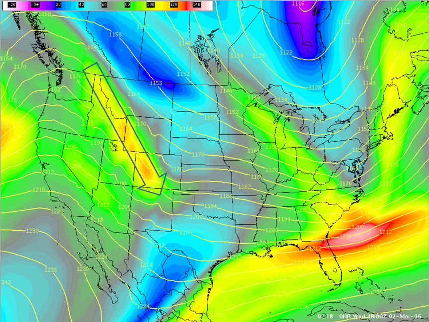
Precipitation and snowfall forecasts just keep getting bigger as weather models agree more each day and the major pattern change gets closer.

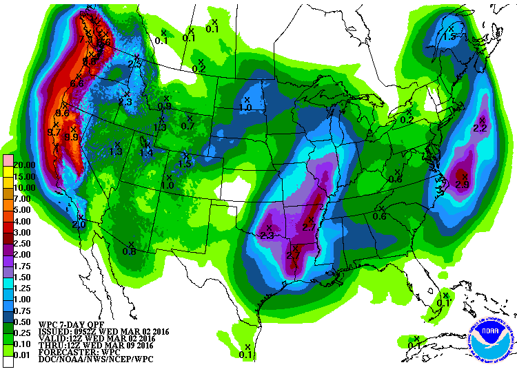
The West Coast continues to put up staggering numbers with some forecasts showing up to 6-10″ of liquid precipitation on the West Coast next 7 days (6-10″ of liquid precipitation could translate to 6-10 feet of snow if it all comes in as snow…).  

The Western USA appears to be in for a very snowy month of March.

Current 7-day liquid precipitation forecast showing insane amounts of precip headed to the West Coast. 10" of precip forecast for NorCal could equal 10-feet of snow if all comes as snow. image: noaa, today
Current 7-day liquid precipitation forecast showing insane amounts of precip headed to the West Coast. 6-10″ of liquid precipitation forecast along the West Coast could equal 6-10-feet of snow if all comes as snow. image: noaa, today

California: 

  • CALIFORNIA’s Sierra Nevada & Cascade mountains = NOAA is calling for a “Good Atmospheric River” to hit  on Saturday/Sunday with up to 3″ of liquid precipitation (potentially 3-feet of snow) forecast on the Sierra Crest near Lake Tahoe, CA by Sunday evening .
    "The precip will be intense for a 12 hour period Saturday night into Sunday morning
    with a good atmospheric river and strong forcing. First guess
    precip amounts of 3+ inches along the Sierra Crest." - NOAA Reno, NV today


  • NOAA’s long range hazard forecast is calling for “Heavy Snow” in the Sierra Nevada everyday from March 5th – March 14th (see images near bottom of article).  That would be one helluva long cycle…
  • NOAA’s liquid precipitation forecast for the northern Sierra Nevada is showing 10″ of liquid precipitation falling in the next 7-days.  10″ of liquid precipitation would translate to 10-feet of snow if it all comes in as snow.
  • Brian Allegretto of Opensnow.com is forecasting 26-40″ of snow above 8,000-feet in Lake Tahoe, CA by Monday.
  • Mammoth Mountain Weather Guy is forecasting 120-150″ of snowfall for Mammoth, CA in the month of March.
"The first in a long series of weather systems will arrive in Northern California tomorrow. This system basically sacrifices itself to break down California's persistent ridge of high pressure, but will clear the way for a much wetter storm on Saturday!" - NOAA Sacramento, CA today
“The first in a long series of weather systems will arrive in Northern California tomorrow. This system basically sacrifices itself to break down California’s persistent ridge of high pressure, but will clear the way for a much wetter storm on Saturday!” – NOAA Sacramento, CA today

Oregon, Washington:

  • OREGON’s Cascade mountains (Mt. Hood, Mt. Bachelor) are looking at a range from 2-3″ of liquid precipitation in the next 7-days, which would translate to about 2-3 feet of snowfall.  
  • WASHINGTON’s Cascade mountains (Mt. Baker ski area, Crystal Mountain) are looking at a range from 2-3″ of liquid precipitation in the next 7-days, which would translate to about 2-3 feet of snowfall.  
" Here's an early look at the forecast precipitation totals for Northern California! Potentially 5 to 10 inches of rain will be possible across the interior mountains, with 2 to 6 inches for the lower elevations. The heaviest precipitation will arrive on Saturday, but periods of light to moderate precipitation are likely between Thursday and Monday." - NOAA Sacramento, CA today

Here’s an early look at the forecast precipitation totals for Northern California! Potentially 5 to 10 inches of rain will be possible across the interior mountains, with 2 to 6 inches for the lower elevations.
The heaviest precipitation will arrive on Saturday, but periods of light to moderate precipitation are likely between Thursday and Monday.” – NOAA Sacramento, CA today

Idaho, Wyoming, Montana: 

  • Idaho (Schweitzer, Sun Valley) is forecast to see around 2.5″ of liquid precipitation in the next 7-days, which would translate to about 2.5-feet of snowfall.  
  • The Teton mountains of Wyoming (Grand Targhee, Jackson Hole) are forecast to see 1.3″of liquid precipitation in the next 7-days, which would translate to about 16″ of snowfall.  
  • Southern Montana (Big Sky, Bridger Bowl) is forecast to see about .8″ of liquid precipitation in the next 7-days, which would translate to about 10″ of snowfall.  
"So where's all the wind coming from? The image below shows the jet stream at 200mb (around 32,000 feet). The yellow, orange, and red colors indicate the strongest speeds. Over Colorado, the jet stream is reaching speeds of 120kts or so and is mixing down to the surface causing the gusty winds. You can also see the ridge of high pressure to our west which will continue to build in and bring pleasant weather for the next few days." - NOAA Grand Junction, CO today
“So where’s all the wind coming from? The image below shows the jet stream at 200mb (around 32,000 feet). The yellow, orange, and red colors indicate the strongest speeds. Over Colorado, the jet stream is reaching speeds of 120kts or so and is mixing down to the surface causing the gusty winds. You can also see the ridge of high pressure to our west which will continue to build in and bring pleasant weather for the next few days.” – NOAA Grand Junction, CO today

Colorado:

  • Colorado is forecast to see 1-1.5″of liquid precipitation forecast the next 7-days, which would translate to around a 12-18″ of snowfall.  
Current 6-10 day outlook from NOAA showing above average precipitation forecast for just about all of the Western USA.  image:  noaa, today
Current 6-10 day outlook from NOAA showing above average precipitation forecast for just about all of the Western USA. image: noaa, today

Utah:

  • NOAA is forecasting 1-1.4″ of liquid forecast for Utah the next 7-days which would translate to around 12-16″ of snowfall.  Powder Mountain & Snowbasin look like they’ll do well in this cycle.  Alta, Snowbird, Solitude, and Brighton always seem to get more snow than forecast…

MORE MIRACLE MARCH INFO:

Current 6-10 day outlook from NOAA showing below average temperatures forecast for CA, OR, NV, UT, AZ, NM. image: noaa, today

(read the captions under each image for more detail)

The GFS weather model showing around 2.5" of precipitation for the Sierra Nevada mountains of CA in the next 4 days. 2.5" of liquid precip. could equal around 2.5-feet of snow if it all comes as snow.
The GFS weather model showing around 2.5″ of precipitation for the Sierra Nevada mountains of CA in the next 4 days. 2.5″ of liquid precip. could equal around 2.5-feet of snow if it all comes as snow.
These storms will be pushed into the Western US by a powerful, dropping jet stream. This image shows the forecast jetstream for March 7th. image: noaa, yesterday
Forecast jet stream coming right through CA and the Western USA in the next 6-10 days. image: noaa, today
"Heavy snow" forecast in CA March 5-9th. image: noaa, today
“Heavy snow” forecast in CA March 5-9th. image: noaa, today
"Heavy snow" forecast in CA March 10-14th. image: noaa, today
“Heavy snow” forecast in CA March 10-14th. image: noaa, today
"Plans in the Sierra? Prepare for a big change in the weather beginning this weekend, with snow measured in feet expected in the higher terrain above 6,000 feet by Monday." - NOAA Las Vegas, NV today
“Plans in the Sierra? Prepare for a big change in the weather beginning this weekend, with snow measured in feet expected in the higher terrain above 6,000 feet by Monday.” – NOAA Las Vegas, NV today
"A transition to an active and wet pattern will begin this weekend and persist into next week. The first of the series of storms is expected around the Friday night into Saturday morning timeframe. This system will be a weaker and warmer storm which may produce travel impacts across Sierra passes. The next system will push through the region Saturday night through Monday morning which should be a moderate and colder storm with travel impacts expected. The active pattern will continue with the potential for additional moderate to strong storms possible next week." - NOAA Reno, NV today
“A transition to an active and wet pattern will begin this weekend and persist into next week. The first of the series of storms is expected around the Friday night into Saturday morning timeframe. This system will be a weaker and warmer storm which may produce travel impacts across Sierra passes. The next system will push through the region Saturday night through Monday morning which should be a moderate and colder storm with travel impacts expected. The active pattern will continue with the potential for additional moderate to strong storms possible next week.” – NOAA Reno, NV today
"Precipitation returns to Central California this weekend and early next week. 6 day forecast through March 8:" - NOAA Hanford, CA today
“Precipitation returns to Central California this weekend and early next week. 6 day forecast through March 8:” – NOAA Hanford, CA today

Related Articles

Got an opinion? Let us know...