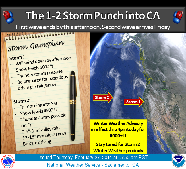
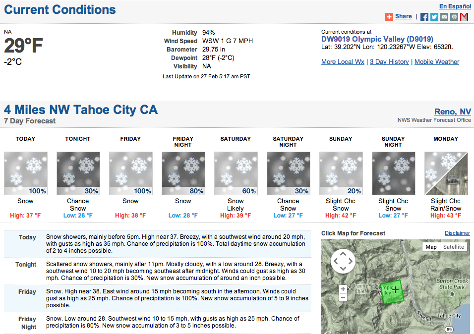
Lake Tahoe just got a storm that dropped around 10″ of new snow. Another 6 inches is forecasted this morning before another storm slams into Tahoe on Friday. 16″ of new snow is forecast this weekend.
The wet weather pattern that began yesterday will continue into the weekend as two storm waves impact NorCal. The first wave arrived yesterday and will linger into this afternoon. Thunderstorms still possible this morning which could produce locally heavy rainfall and lightning. Motorists should take caution as hazardous driving conditions are expected due to rain and snow. Check road conditions! The next storm arrives by Friday morning and will linger into Saturday, but the brunt of the storm is expected Friday as thunderstorms are possible again along with moderate to heavy rain/snow. – NOAA Sacramento, CA
Winter Weather Advisory for Tahoe Today
URGENT - WINTER WEATHER MESSAGE
NATIONAL WEATHER SERVICE RENO NV
332 AM PST THU FEB 27 2014

...WINTER WEATHER ADVISORY REMAINS IN EFFECT UNTIL 10 AM PST THIS
MORNING...

A WINTER WEATHER ADVISORY FOR SNOW REMAINS IN EFFECT UNTIL 10 AM
PST THIS MORNING.

* TIMING: SHOWERS WILL CONTINUE THROUGH LATE THIS MORNING WITH A
  PERIOD OF MODERATE TO HEAVY SNOW THROUGH 6 AM.

* ADDITIONAL SNOW ACCUMULATIONS: 2 TO 4 INCHES AWITH LOCALLY UP TO
  6 INCHES ALONG THE SIERRA CREST.

* SNOW LEVELS: LAKE LEVEL.

* WIND GUSTS: 30 TO 50 MPH OVER RIDGES AND UP TO 25 MPH AT LAKE
  LEVEL.