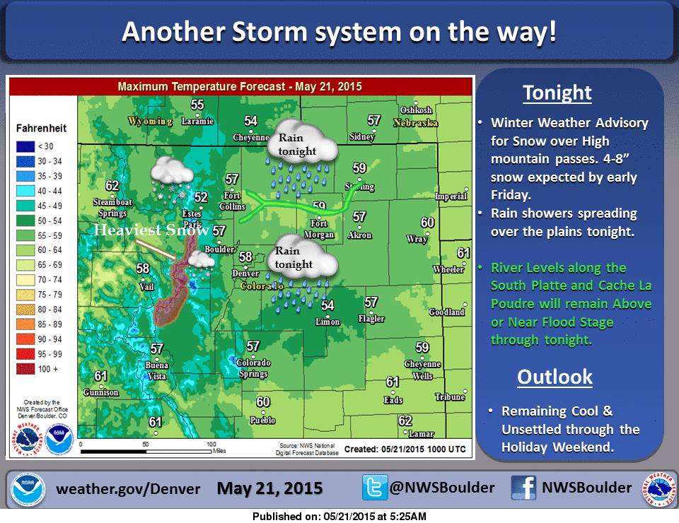
Colorado is having one helluva May. It’s been snowing like crazy this may and it won’t stop. NOAA is forecasting another 3-6″ for Colorado today and tonight and they’ve issued a Winter Weather Advisory.
Arapahoe Basin is still open and they’ve had some great powder days this month. They’ve gotten 9″ in the past 3 days.
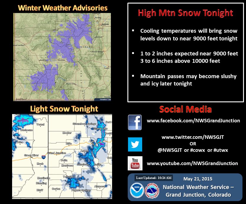
“Spring returns in full swing today, with another surge of moisture producing showers and thunderstorms across the forecast area this afternoon into tonight. Strong southerly winds and locally heavy rainfall are possible with these storms. The San Juan and Central Colorado mountains can expect another round of snow, with areas around 9,000ft receiving up to 2” and elevations above 10,000ft accumulating 3-6” through tomorrow morning. Conditions will clear overnight into early Friday morning before our next low pressure system brings scattered showers and thunderstorms tomorrow evening through Sunday. Temperatures will be unseasonably cool Memorial Day weekend before returning to near normal early next week after the disturbance clears the region.” – NOAA Grand Junction, CO
WINTER WEATHER ADVISORY:
URGENT - WINTER WEATHER MESSAGE
NATIONAL WEATHER SERVICE GRAND JUNCTION CO
415 AM MDT THU MAY 21 2015

...WINTER WEATHER ADVISORY IN EFFECT FROM 6 PM THIS EVENING TO
6 AM MDT FRIDAY ABOVE 9000 FEET...

THE NATIONAL WEATHER SERVICE IN GRAND JUNCTION HAS ISSUED A
WINTER WEATHER ADVISORY ABOVE 9000 FEET FOR SNOW...WHICH IS IN
EFFECT FROM 6 PM THIS EVENING TO 6 AM MDT FRIDAY.

* LOCATIONS INCLUDE THE CITIES OF...SNOWMASS...TAYLOR PARK...
  TELLURIDE...SILVERTON...RICO.

* TIMING...WIDESPREAD SNOW SHOWERS IS EXPECTED THIS EVENING...BUT
  WILL BE DIMINISHING AFTER MIDNIGHT.

* SNOW ACCUMULATION...SNOWFALL OF 1-2 INCHES IS POSSIBLE AROUND
  9000 FEET. UPWARDS TO 3-6 INCHES MAY FALL ABOVE 10000 FEET OR OVER
  THE MOUNTAIN PASSES.

* SNOW LEVEL...THE SNOW LEVEL WILL LOWER TO AROUND 9000 FEET THIS
  EVENING.

* WINDS...GUSTS UP TO 25 MPH WILL OCCUR WITH INTENSE EVENING SNOW
  SHOWERS.

* IMPACTS...SLUSH AND ICE ON ROADS AND HIGHWAYS WILL OCCUR OVER
  THE MOUNTAIN PASSES.