NOAA: “Atmospheric River” to Drop 2-4 Feet in California by Monday

WeatherBrains | | Post Tag for WeatherWeather
"A large area of significant atmospheric moisture, extending west of the Hawaiian islands, will bring abundant valley and foothill rain as well as mountain snow. The heaviest precipitation will occur over Central California Saturday evening through Sunday morning. Please continue to monitor the forecast for the latest information." - NOAA Reno, NV today
“A large area of significant atmospheric moisture, extending west of the Hawaiian islands, will bring abundant valley and foothill rain as well as mountain snow. The heaviest precipitation will occur over Central California Saturday evening through Sunday morning. Please continue to monitor the forecast for the latest information.” – NOAA Reno, NV today

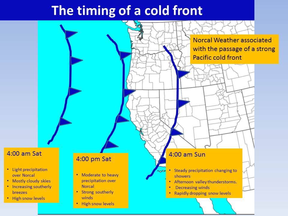
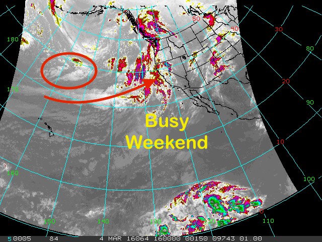
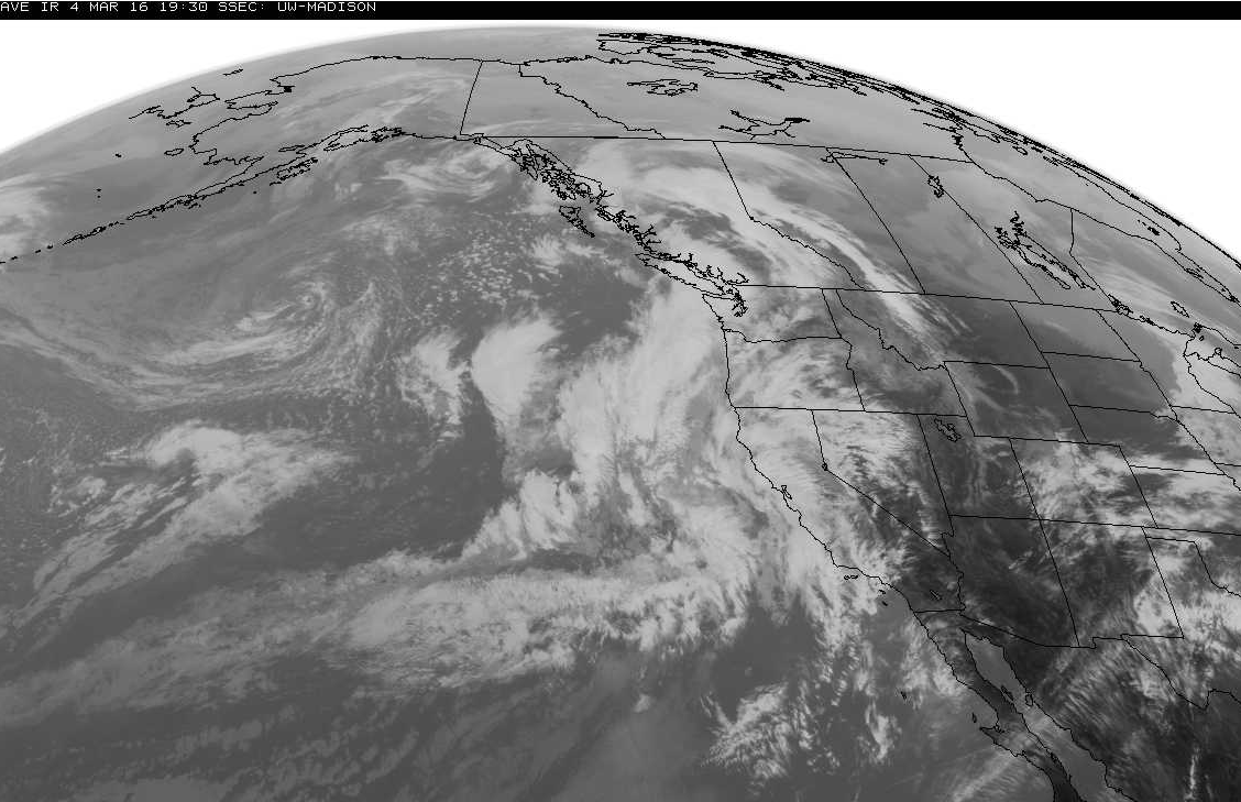
California is about to experience a “parade of storms” this weekend and this month that will potentially bring enormous amounts of snow to its Sierra Nevada and Cascades mountains.

This is what “Miracle March” is all about.

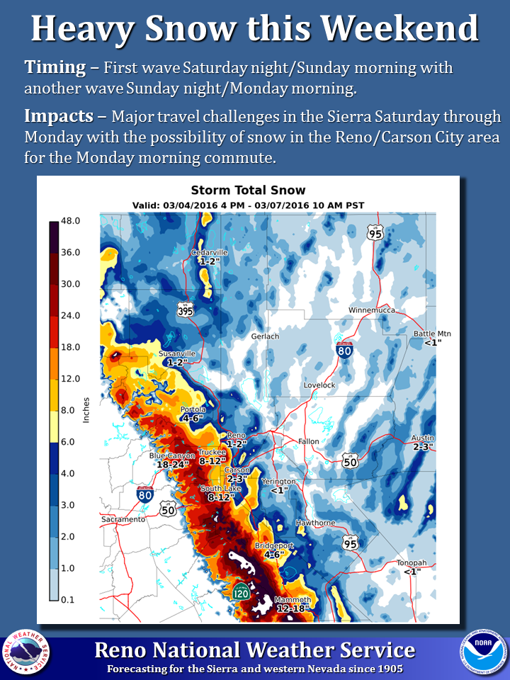
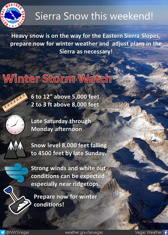
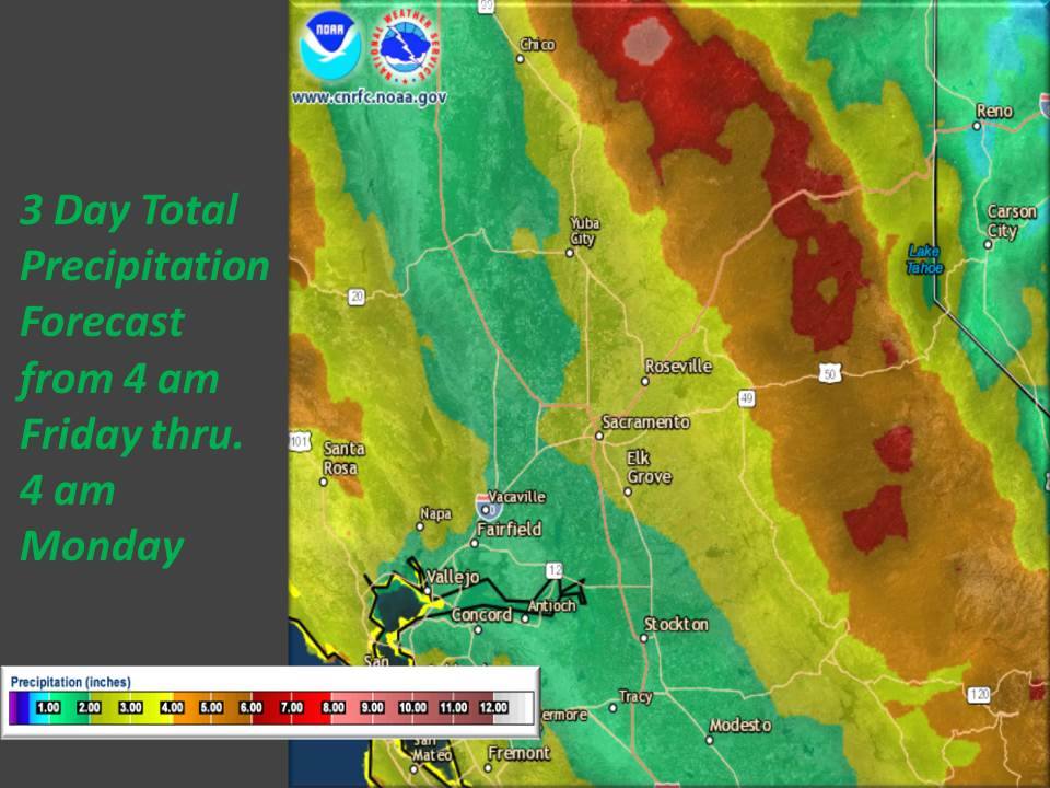
2-4 feet of snow is forecast in the Sierra Nevada’s upper elevations between now and Monday.  NOAA has issued Winter Storm Warnings that cover nearly all of the Sierra (see image near bottom of article).

* SNOW ACCUMULATIONS...1 TO 2 FEET ABOVE 4500 FEET...3 FEET OF
  SNOW OR GREATER POSSIBLE ACROSS THE HIGHEST PEAKS.
  - NOAA for Tahoe region, today

* SNOW TOTALS...2 TO 4 FEET ABOVE 8000 FEET...WITH 1 TO 2 FEET
  BETWEEN 6000 AND 8000 FEET AND UP TO A FOOT AT LOWER
  ELEVATIONS.
  - NOAA for Mammoth region, today
Liquid Precipitation numbers for the next 7-days are insane in CA at up to 13". 13" of liquid precipitation would = 13-feet of snow if it all came as snow. image: noaa, today
Liquid Precipitation numbers for the next 7-days are insane in CA at up to 13″. 13″ of liquid precipitation would = 13-feet of snow if it all came as snow. image: noaa, today

Snow levels will start above 7,000-feet on Saturday before dropping to around 4,000-feet by Monday in Tahoe & Mammoth.

* SNOW LEVELS...ABOVE 7000 FEET ON SATURDAY...LOWERING TO 3500 TO
  4500 FEET SATURDAY NIGHT THROUGH MONDAY. 
  - NOAA for Tahoe region, today

* SNOW LEVELS...STARTING OUT AROUND 8000 FEET SATURDAY EVENING
  THEN LOWERING TO NEAR 4000 FEET BY SUNDAY AFTERNOON. SNOW
  LEVELS WILL REMAIN CLOSE TO 4000 FEET THROUGH MONDAY. 
  - NOAA for Mammoth region, today
"2 waves of heavy precipitation will bring rain and heavy snow to the Sierra this weekend. Rain will begin in the Sierra on Friday with rain on and off through Saturday. Snow levels are expected to start around 8000 to 9000 feet and drop rapidly late Saturday night. The first round of heavy snow is expected late Saturday night through Sunday Morning with a second colder storm expected Sunday night through Monday morning. " - NOAA Reno, NV today
“2 waves of heavy precipitation will bring rain and heavy snow to the Sierra this weekend. Rain will begin in the Sierra on Friday with rain on and off through Saturday. Snow levels are expected to start around 8000 to 9000 feet and drop rapidly late Saturday night. The first round of heavy snow is expected late Saturday night through Sunday Morning with a second colder storm expected Sunday night through Monday morning. ” – NOAA Reno, NV today

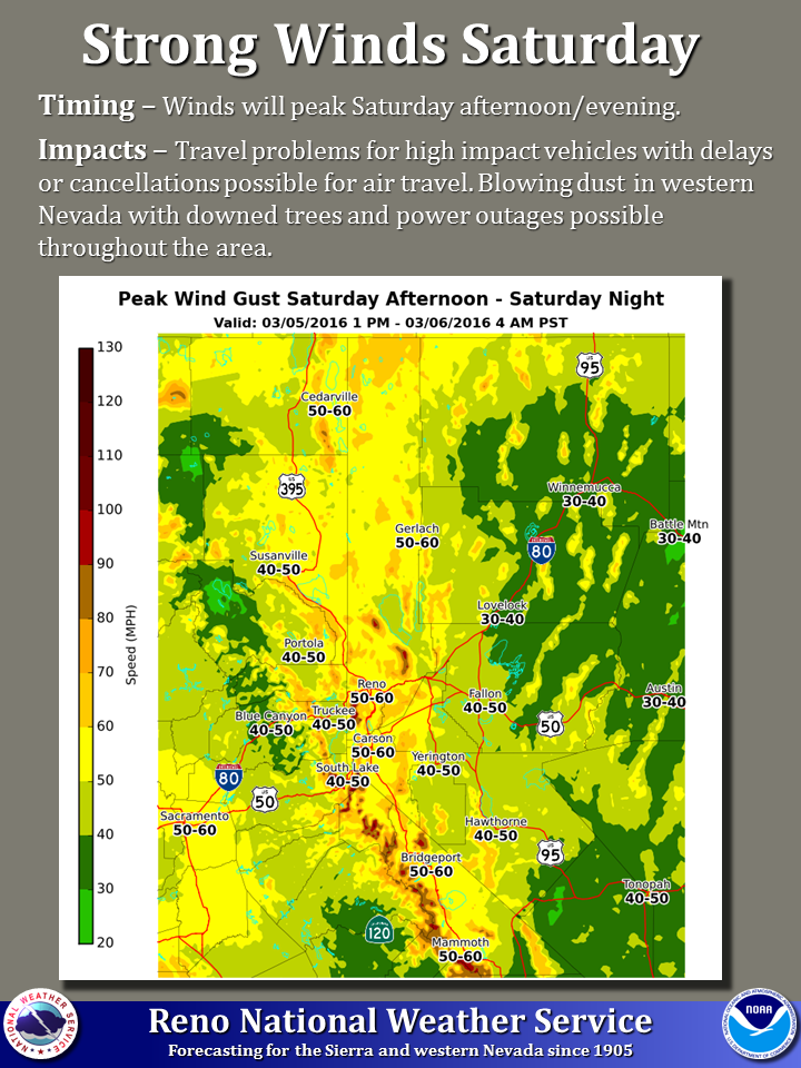
Winds will be very strong with this weekend’s storm with gusts up to 120mph are expected.  This wind will most likely close upper mountains and entire ski resorts throughout California on Saturday.

“Winds are expected to peak Saturday afternoon into Saturday evening with widespread gusts of 45-60 mph. Wind-prone areas of western Nevada could see gusts of 70 mph with Sierra ridge-tops receiving wind gusts of 100-120 mph.” – NOAA Reno, NV today

"Winds are expected to peak Saturday afternoon into Saturday evening with widespread gusts of 45-60 mph. Wind-prone areas of western Nevada could see gusts of 70 mph with Sierra ridge-tops receiving wind gusts of 100-120 mph." - NOAA Reno, NV today
“Winds are expected to peak Saturday afternoon into Saturday evening with widespread gusts of 45-60 mph. Wind-prone areas of western Nevada could see gusts of 70 mph with Sierra ridge-tops receiving wind gusts of 100-120 mph.” – NOAA Reno, NV today

NOAA’s Long Term “Miracle March” Outlooks for California:

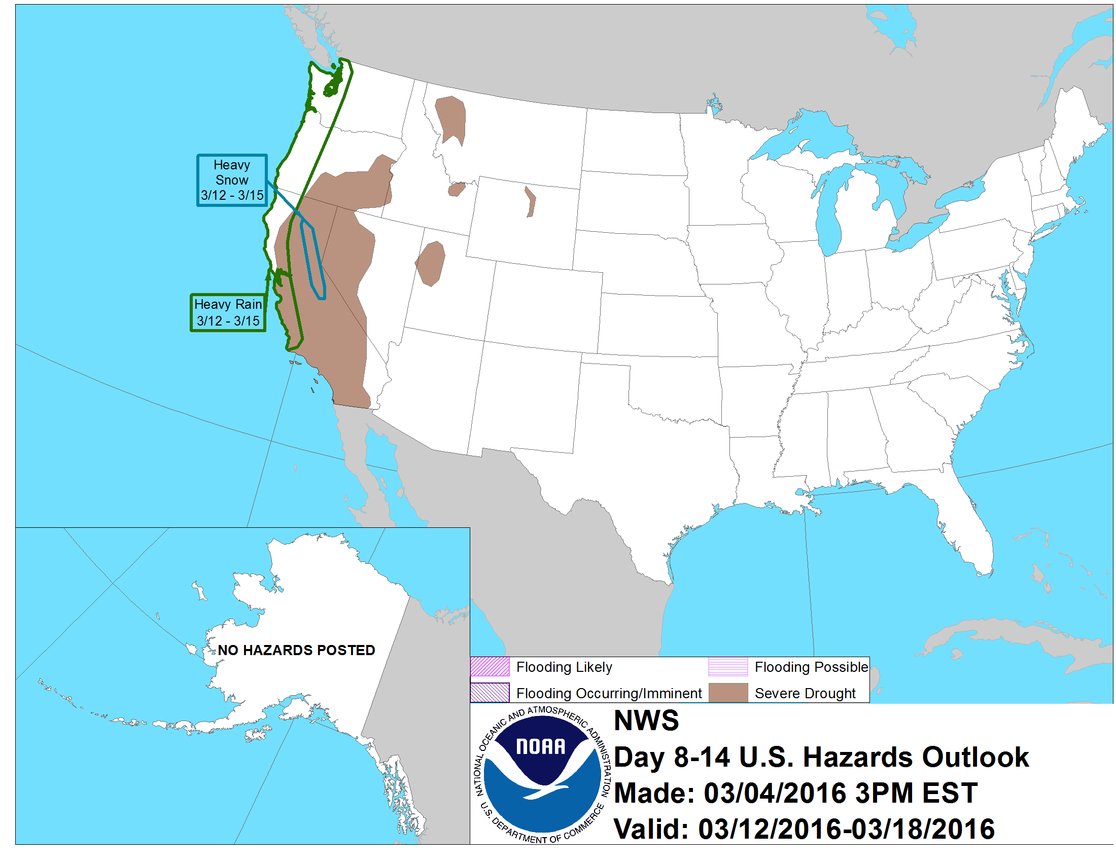
  • NOAA is calling for “Heavy Snow” in the Sierra for 9-straight-days from March 8th until March 15th (see images below).
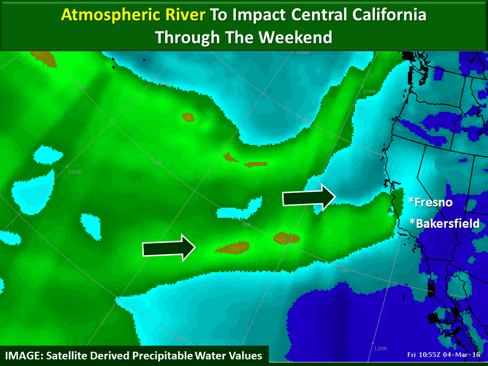
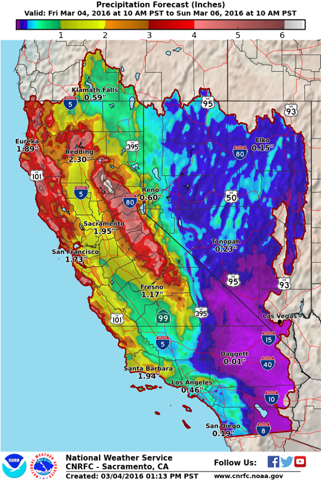
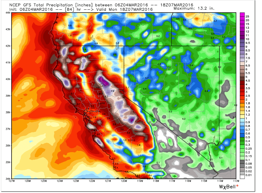
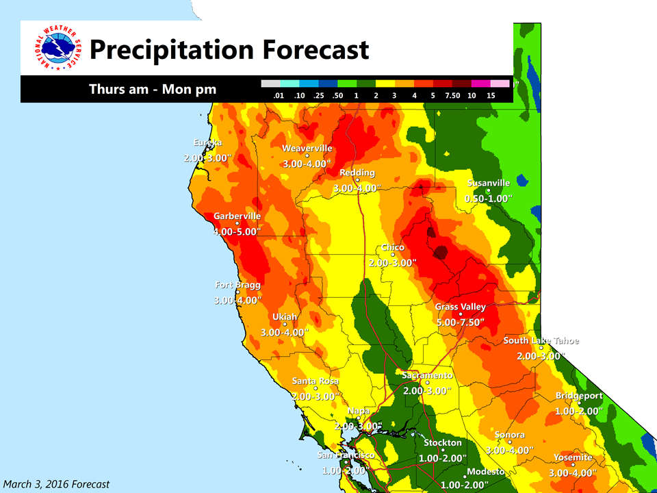
  • NOAA’s 7-day liquid precipitation forecast is calling for up to 13″ of liquid precipitation in the Sierra in the next 7-days.  If that all came as snow, it would translate to around 13-feet of snowfall (see image near top of article)...
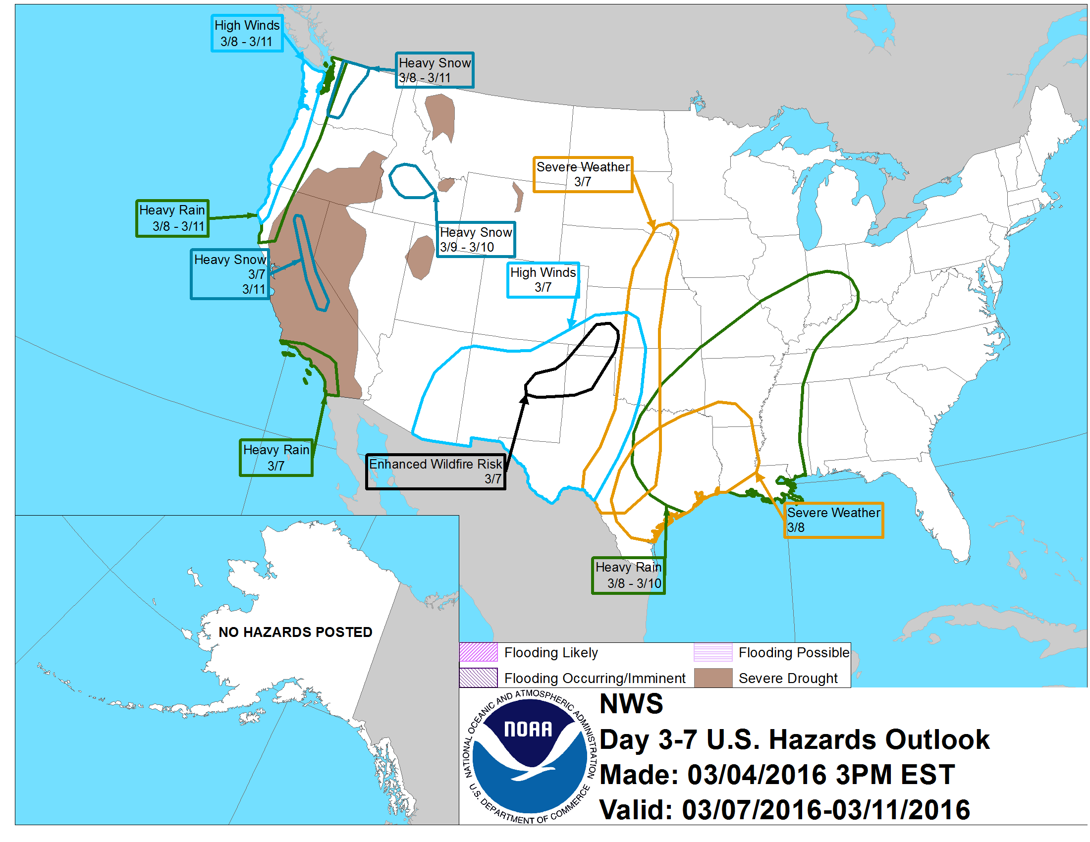
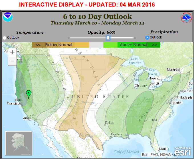
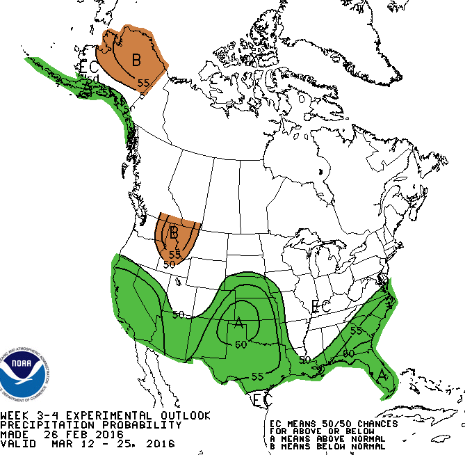
  • NOAA’s long range forecasts are showing above average precipitation falling in CA in the 6-10 day outlook, in the 8-14 day outlook, and even the 3-4 week outlook – that’s above average precipitation from now until early April (see images below)
"Heavy Snow" forecast in CA from March 7-11th. image: noaa, today
“Heavy Snow” forecast in CA from March 7-11th. image: noaa, today
"Heavy Snow" forecast in CA from March 11-14th. image: noaa, today
“Heavy Snow” forecast in CA from March 12-15th. image: noaa, today
Above average precipitation if forecast in CA in the 6-10 day forecast. image: noaa, today
Above average precipitation if forecast in CA in the 8-14 day forecast. image: noaa, today
There is even above average precipitation if forecast in CA in NOAA's new, experimental 3-4 week forecast. image: noaa, today
There is even above average precipitation if forecast in CA in NOAA’s new, experimental 3-4 week forecast. image: noaa, today

7 CALIFORNIA SKI RESORTS WITH OVER 300″ of SNOWFALL THIS SEASON:

  • Sugar Bowl = 382″
  • Sierra at Tahoe = 347″
  • Boreal = 345″
  • Northstar = 338″
  • Kirkwood = 328″
  • Squaw Valley = 324″
  • Alpine Meadows = 315″

The coming “parade of storms” should boost many of these California snowfall totals into the 400″ range and above.

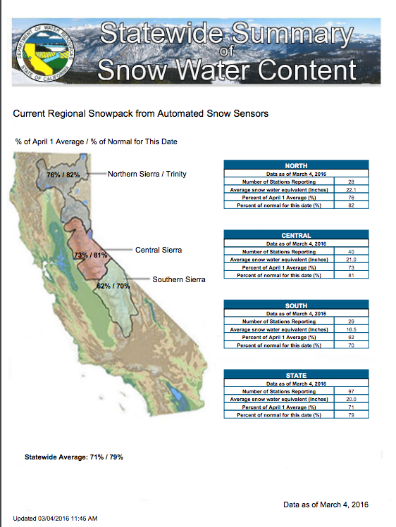
California’s statewide snowpack was at 114% of average a month ago and now it’s below 80% of average to date after a very hot and dry February and early March.

CA snowpack currently below 80% of average to date. image: nws, today

WINTER STORM WATCH for TAHOE REGION:  

URGENT - WINTER WEATHER MESSAGE
NATIONAL WEATHER SERVICE SACRAMENTO CA
209 PM PST FRI MAR 4 2016

...STRONG WINTER STORM THIS WEEKEND...

.A STRONG WINTER STORM WILL MOVE THROUGH NORTHERN CALIFORNIA
SATURDAY THROUGH MONDAY. SNOW LEVELS WILL INITIALLY START ABOVE
7000 FEET... BUT RAPIDLY LOWER TO BETWEEN 3500 AND 4500 FEET
SATURDAY NIGHT THROUGH MONDAY. PERIODS OF HEAVY SNOW AND GUSTY
WINDS WITH CHAIN CONTROLS AND HAZARDOUS TRAVEL ARE EXPECTED DURING
THAT TIME.

WESTERN PLUMAS COUNTY/LASSEN PARK-
WEST SLOPE NORTHERN SIERRA NEVADA-
INCLUDING THE CITIES OF...CHESTER...QUINCY...BLUE CANYON

...WINTER STORM WARNING IN EFFECT FROM 10 PM SATURDAY TO 4 PM PST
MONDAY...

THE NATIONAL WEATHER SERVICE IN SACRAMENTO HAS ISSUED A WINTER
STORM WARNING FOR HEAVY SNOW...WHICH IS IN EFFECT FROM 10 PM
SATURDAY TO 4 PM PST MONDAY. THE WINTER STORM WATCH IS NO LONGER
IN EFFECT.

* IMPACTS...PERIODS OF HEAVY SNOW AND GUSTY WINDS WILL LIKELY
  CAUSE HAZARDOUS TRAVEL AND CHAIN CONTROLS.

* TIMING...SATURDAY NIGHT THROUGH MONDAY AFTERNOON.

* LOCATIONS...LASSEN NATIONAL PARK...INTERSTATE 80...HIGHWAY
  50...HIGHWAY 88.

* SNOW ACCUMULATIONS...1 TO 2 FEET ABOVE 4500 FEET...3 FEET OF
  SNOW OR GREATER POSSIBLE ACROSS THE HIGHEST PEAKS.

* SNOW LEVELS...ABOVE 7000 FEET ON SATURDAY...LOWERING TO 3500 TO
  4500 FEET SATURDAY NIGHT THROUGH MONDAY.
Pin = Mammoth. BLUE = Winter Storm Watch. PINK = Winter Storm Warning. BLUE = Winter Weather Advisory. image: noaa, today

WINTER STORM WATCH for MAMMOTH REGION:

URGENT - WINTER WEATHER MESSAGE
NATIONAL WEATHER SERVICE HANFORD CA
159 PM PST FRI MAR 4 2016

SIERRA NEVADA FROM YOSEMITE TO KINGS CANYON-
TULARE COUNTY MOUNTAINS-
INCLUDING THE CITIES OF...SHAVER LAKE...YOSEMITE VALLEY...
CAMP NELSON...GIANT FOREST...JOHNSONDALE...LODGEPOLE

...WINTER STORM WARNING IN EFFECT FROM 4 PM SATURDAY TO 6 PM PST
MONDAY...

THE NATIONAL WEATHER SERVICE IN HANFORD HAS ISSUED A WINTER STORM
WARNING FOR HEAVY SNOW...WHICH IS IN EFFECT FROM 4 PM SATURDAY TO
6 PM PST MONDAY. THE WINTER STORM WATCH IS NO LONGER IN EFFECT.

* SNOW TOTALS...2 TO 4 FEET ABOVE 8000 FEET...WITH 1 TO 2 FEET
  BETWEEN 6000 AND 8000 FEET AND UP TO A FOOT AT LOWER
  ELEVATIONS.

* SNOW LEVELS...STARTING OUT AROUND 8000 FEET SATURDAY EVENING
  THEN LOWERING TO NEAR 4000 FEET BY SUNDAY AFTERNOON. SNOW
  LEVELS WILL REMAIN CLOSE TO 4000 FEET THROUGH MONDAY.

* TIMING...SNOW WILL BEGIN ABOVE 8000 FEET SATURDAY AFTERNOON WITH
  THE HEAVIEST SNOW EXPECTED SATURDAY NIGHT. SNOW WILL CONTINUE
  HEAVY AT TIMES THROUGH MONDAY.

* IMPACTS...BLOWING AND DRIFTING SNOW WITH LOCAL WHITEOUT
  CONDITIONS...HAZARDOUS WINTER TRAVEL...POSSIBLE ROAD
  CLOSURES...AND CHAIN REQUIREMENTS. SNOW AND GUSTY WINDS MAY
  CAUSE FALLING TREE BRANCHES OR LIMBS.

MORE MIRACLE MARCH INFO for CA:

(read captions for more detailed information)

"It's coming, significant snowfall is on the way for the Eastern Sierra Slopes. A Winter Storm Watch has been issued for late Saturday through Monday afternoon, prepare now for winter weather." - NOAA, Las Vegas, NV today
“It’s coming, significant snowfall is on the way for the Eastern Sierra Slopes. A Winter Storm Watch has been issued for late Saturday through Monday afternoon, prepare now for winter weather.” – NOAA, Las Vegas, NV today
"A strong Pacific cold front is forecast to move through northern California Saturday evening. Here is a look at the weather expected before, during and after this system passes through the north state. Strong winds and heavy rain will precede this system with showers and lower snow levels in the cooler air behind it." - NOAA Sacramento, CA today
“A strong Pacific cold front is forecast to move through northern California Saturday evening. Here is a look at the weather expected before, during and after this system passes through the north state. Strong winds and heavy rain will precede this system with showers and lower snow levels in the cooler air behind it.” – NOAA Sacramento, CA today
Big precip coming to CA next
Big precip coming to CA next 3 days.  image:  noaa, today
"Here's a 3 day total precipitation forecast from 4 am Friday through 4 am Monday." - NOAA Sacramento, CA today
“Here’s a 3 day total precipitation forecast from 4 am Friday through 4 am Monday.” – NOAA Sacramento, CA today
Here come the storms. image: nasa, today
The GFS weather model is showing enormous precipitation totals in the Sierra between now and March 7th.
Current satellite imagery of the first of the "parade of storms" hitting CA this weekend and early next week. image: nasa
Current satellite imagery of the first of the “parade of storms” hitting CA this weekend and early next week. image: nasa
3-5" of liquid precipitation is forecast in the Sierra by Monday.  If that all comes as snow it would translate to about 3-5 feet of snowfall.  image:  noaa, today
3-5″ of liquid precipitation is forecast in the Sierra by Monday.  If that all comes as snow it would translate to about 3-5 feet of snowfall.  image:  noaa, today

Related Articles

One thought on “NOAA: “Atmospheric River” to Drop 2-4 Feet in California by Monday

Got an opinion? Let us know...