
NOAA continues to track a cold Gulf of Alaska storm that will be impacting California this weekend. This storm is forecast to drop 4-12″ of snow in Tahoe with snow levels as low as 3,500-feet. The Mammoth region is now forecast to see 12″ of snow on the Sierra crest.
THE STORM SYSTEM IS STILL ON TRACK TO BRING WEATHER IMPACTS
SATURDAY NIGHT THROUGH SUNDAY. - NOAA Reno, NV today
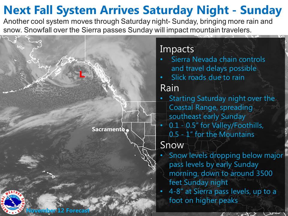
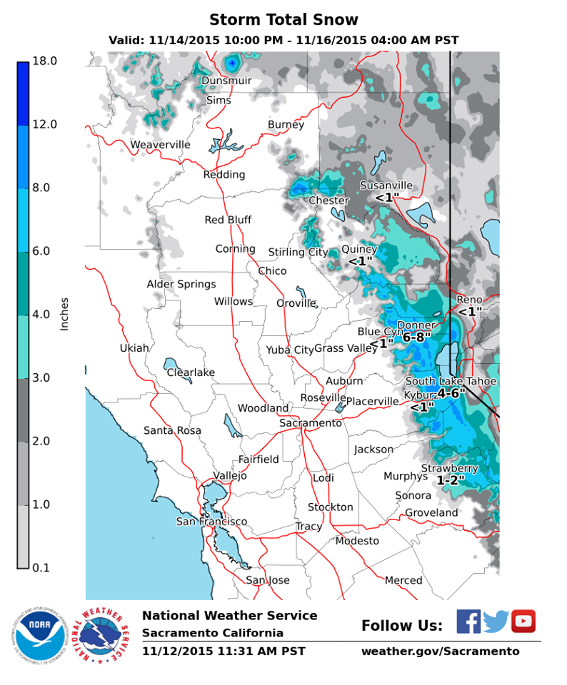
Snow totals for the Tahoe Basin will be around 6″ with up to 12″ of snow on the Sierra crest and west slope of the Sierra.
MOST OF THE PROJECTED SNOW AMOUNTS FOR THE SIERRA AND NORTHEAST
CALIFORNIA ARE STILL ON TRACK, WITH UP TO 6 INCHES POSSIBLE AROUND
THE TAHOE BASIN AND NORTHWARD ACROSS SIERRA, PLUMAS AND WESTERN
LASSEN COUNTIES. HIGHER SNOW AMOUNTS OF 6-12 INCHES ARE POSSIBLE
FOR AREAS NEAR THE SIERRA CREST WEST OF TAHOE, AND FOR HIGHER
PASSES IN NORTHEAST CA SUCH AS YUBA PASS AND FREDONYER SUMMIT.
- NOAA Reno, NV today
Mammoth is now forecast to see big snow out of this system as well with up to 12″ of snow on the Sierra crest.
THE MOISTURE FEED APPEARS TO BE HOLDING TOGETHER A LITTLE BETTER AS IT
MOVES INTO MONO COUNTY [Mammoth], SO WE INCREASED SNOW TOTALS WEST OF
HIGHWAY 395 WITH LOCALLY UP TO 12 INCHES ALSO POSSIBLE ALONG THE
CREST. - NOAA Reno, NV today
Snow levels will be start out high around 7,000-feet before rapidly crashing down to 3,500-feet on Sunday. Most of the precipitation from this storm will fall on Sunday when snow levels are down to valley floors.
Snow levels will drop from 6500-7500 feet Saturday night down to 4500-5500 Sunday and 3500 to 4500 feet Sunday night.” – NOAA Sacramento, CA today

The Lake Tahoe region could experience its first ski resort powder days this week as Tahoe will have 7 ski resorts open this weekend. It’s been a long time since Tahoe has had this many ski resorts open this early in the season.
Mt. Rose and Boreal are currently open in Lake Tahoe and Mammoth is open in central California. Alpine Meadows will opened yesterday and Squaw will open on Saturday. Northstar and Heavenly will open this weekend. Kirkwood will open this weekend with the most terrain open in Lake Tahoe and the only expert terrain Tahoe.
**Special Note: Please be careful if you head into the backcountry after this snowfall. It’s been a mess out there with literally hundreds of people skiing the same zones with major lack of avalanche etiquette.
A skier was partially buried in an avalanche near Kirkwood on Wednesday after taking a 150-foot ride.
