Halloween is my favorite holiday. This year, it’s everyone in NorCal’s favorite holiday. C’mon, do I even have to explain why?
The Giants just won their 3rd World Series in 5 years & it’s gonna snow 14″ in Tahoe this weekend with snow levels down to 4,500-feet!

It truly doesn’t get much better than this if you’re a NorCal resident. Fired up doesn’t even begin to explain it.
NOAA Sacramento, CA:
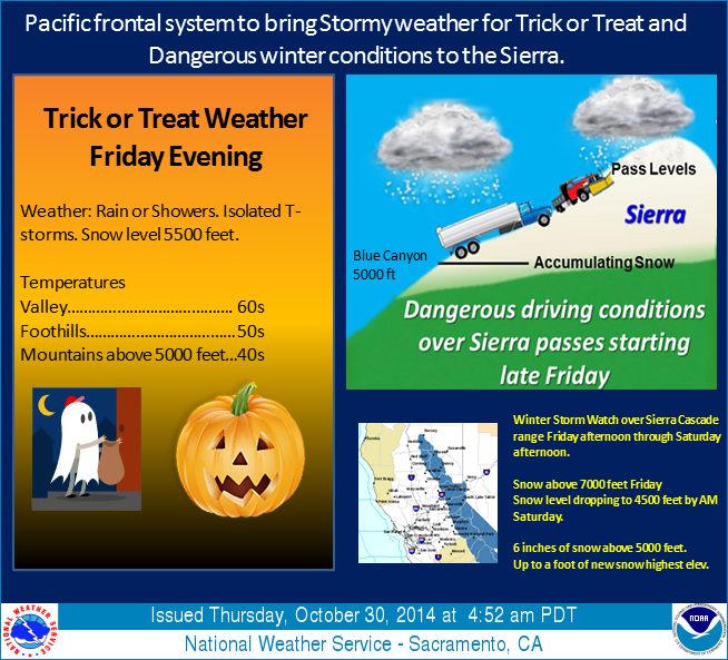
A Pacific Frontal system is forecast to move into northern California on Friday afternoon with the frontal passage through the central valley expected early Friday evening. Therefore trick or treaters could see fairly wet conditions throughout the evening hours Friday. Wet weather in the valley will translate into possibly hazardous conditions over the Sierra as rain turns to snow at the higher elevations. Snow levels Friday evening will be around 7000 feet then drop quickly during the night lowering to around 4500 to 5000 feet by Saturday morning. Several inches of snow are possible.
NOAA Winter Storm Watch:
URGENT - WINTER WEATHER MESSAGE
NATIONAL WEATHER SERVICE RENO NV
317 AM PDT THU OCT 30 2014

...FIRST WINTER STORM OF THE SEASON FOR HALLOWEEN...

.AN EARLY SEASON WINTER STORM WILL BRING A PERIOD OF MODERATE TO
HEAVY SNOW WITH GUSTY WINDS TO THE SIERRA FRIDAY EVENING INTO
SATURDAY MORNING. DRIVERS SHOULD EXPECT CHAIN CONTROLS AROUND THE
LAKE TAHOE BASIN AND WINTER CLOSERS FOR THE SIERRA PASSES IN
ALPINE AND MONO COUNTIES.

A WINTER STORM WATCH REMAINS IN EFFECT FROM FRIDAY AFTERNOON
THROUGH SATURDAY MORNING.

* TIMING: AN EARLY SEASON WINTER STORM WILL MOVE INTO THE LAKE
  TAHOE BASIN AND ALPINE COUNTY FRIDAY AFTERNOON. A PERIOD OF
  MODERATE TO HEAVY SNOW IS LIKELY FRIDAY NIGHT.

* SNOW ACCUMULATIONS: 8 TO 14 INCHES ABOVE 7000 FEET. UP TO 6
  INCHES BELOW 7000 FEET...EXCEPT 5 TO 10 INCHES ARE POSSIBLE
  ALONG AND WEST OF HIGHWAY 89.

* WINDS: SOUTHWEST 15 TO 25 MPH WITH GUSTS UP TO 35 MPH. GUSTS
  NEAR 60 MPH ARE POSSIBLE OVER RIDGES AND THROUGH MOUNTAIN
  PASSES.

* SNOW LEVELS: 7500 TO 8000 FEET ON FRIDAY MORNING...LOWERING TO
  6500 TO 7000 FEET FRIDAY EVENING...THEN FALLING TO NEAR 5000
  FEET SATURDAY MORNING.

* IMPACTS: SLICK AND SNOW COVERED ROADS AROUND THE TAHOE BASIN
  AND ALPINE COUNTY. THIS INCLUDES INTERSTATE 80 AND HIGHWAYS
  50...88... 89...267 AND THE MOUNT ROSE HIGHWAY. SNOW MAY LEAD TO
  THE WINTER CLOSURE OF EBBETTS AND MONITOR PASSES IN ALPINE
  COUNTY.