
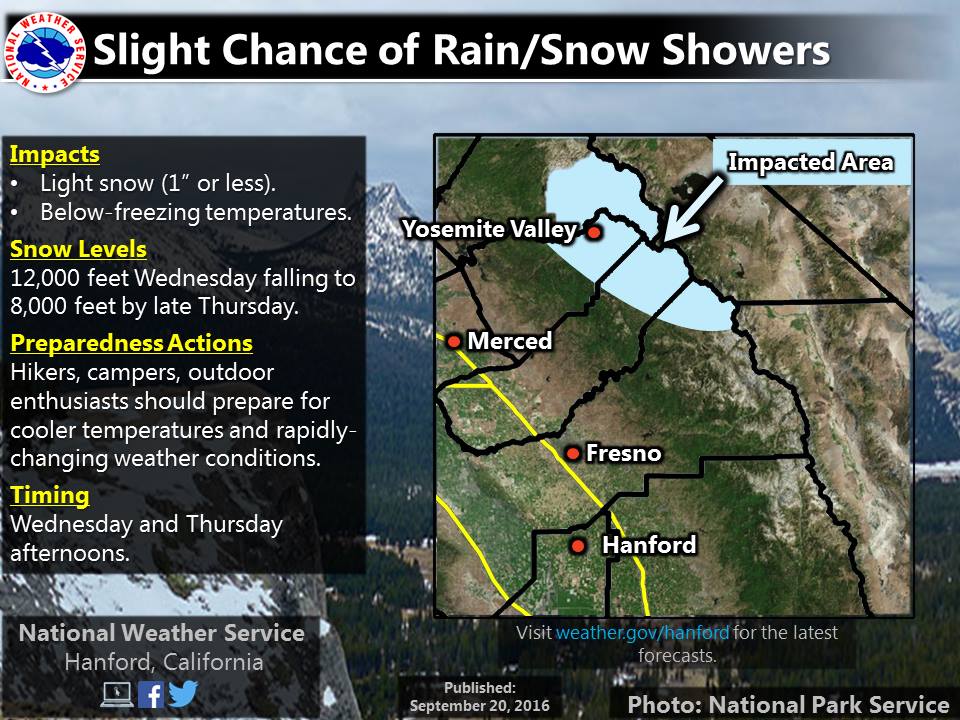
NOAA has issued a Special Weather Statement that outlines “drastically cooler temperatures” and snowfall in California on Wednesday-Thursday this week. They’re calling for light snow in California with snow levels as low as 6,500-feet.
LOW PRESSURE FROM NEAR VANCOUVER ISLAND WILL DROP
SOUTHWARD AND SETTLE OVER NORTHERN CALIFORNIA BY THE MIDDLE OF
THE WEEK. THIS WEATHER SYSTEM WILL BRING DRASTICALLY COOLER
TEMPERATURES BY MIDWEEK, ALONG WITH BREEZY SOUTHWEST WINDS AND A
CHANCE OF MOUNTAIN SHOWERS AND THUNDERSTORMS. A DUSTING OF SNOW IS
ALSO POSSIBLE OVER THE HIGHER MOUNTAIN ELEVATIONS.

CHANCE OF MOUNTAIN SNOW SHOWERS ABOVE 6500 TO 7500 FEET.

- NOAA Reno, NV today

The jet stream is forecast to dip into northern California bringing unseasonably cold temps and the chance for snow in the Sierra Nevada and Cascade mountains. Snow levels could dip as low as 7,000-feet in Lake Tahoe.
Right now, it looks like Tahoe, Yosemite, and Mammoth may get a few flakes. We’re hoping for a few inches. Fingers crossed.
NOAA Snow Forecast:
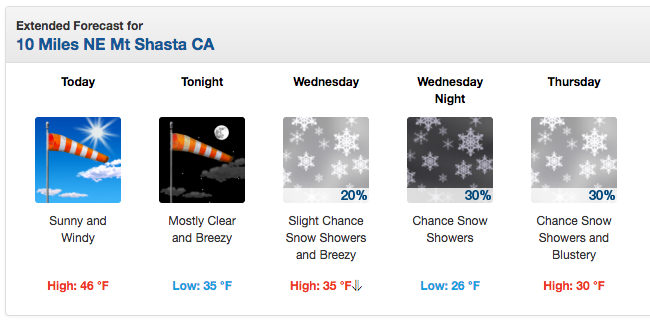
- Mt. Shasta, CA: 30% Chance of Snow on Wednesday & Thursday
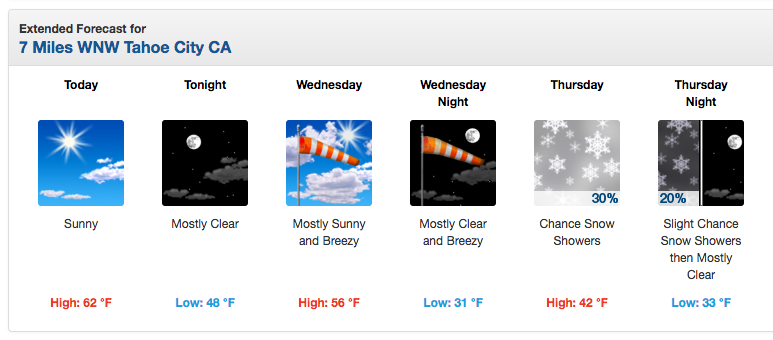
- Squaw Valley, CA: 30% Chance of Snow on Thursday
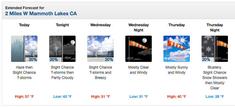
- Mammoth Mountain, CA: 20% Chance of Snow on Thursday
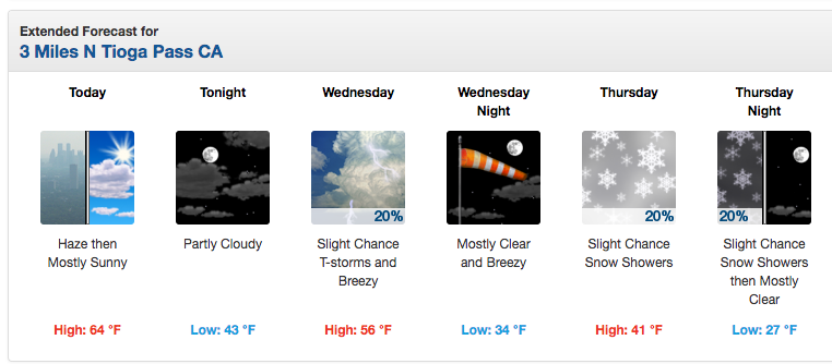
- Tioga Pass, CA (Yosemite): 20% Chance of Snow on Thursday
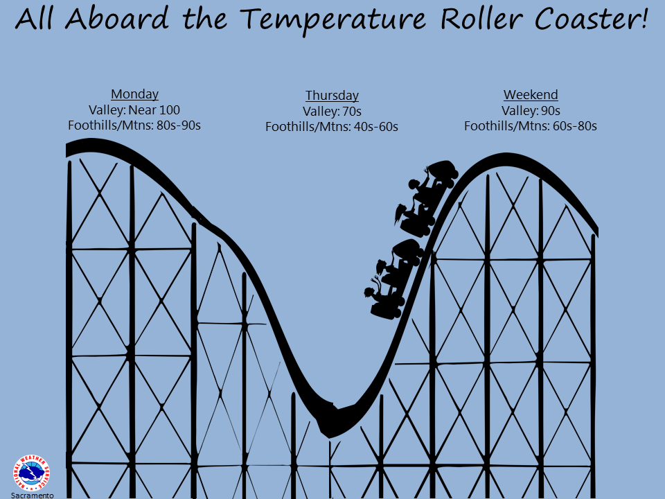
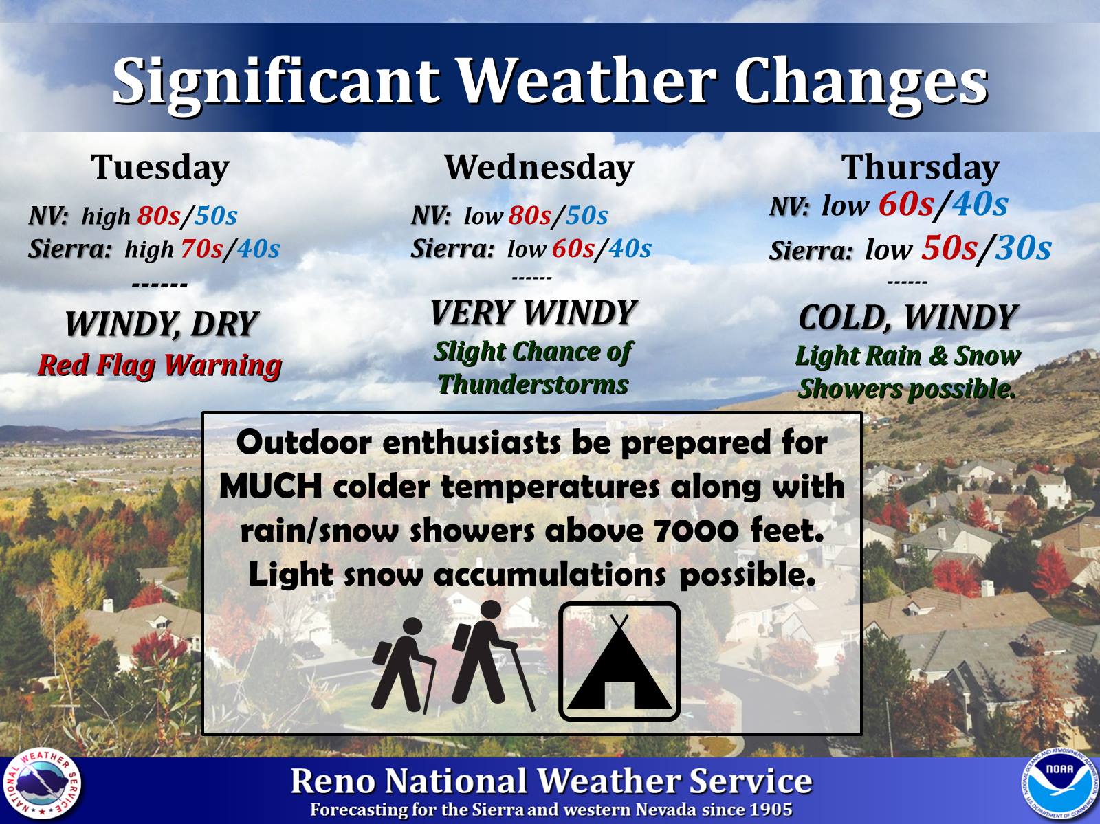
“(There is a) significant pattern change is on tap for Wednesday and Thursday as a cold front and an upper level low push through the area. Main concerns will be for much colder temperatures across the Sierra and Western Nevada. Reno hit a high of 93 (degrees) on Sunday, and we will be around 30 degrees colder by Thursday. There is also potential for frost in some locations in the Sierra and western Nevada. This is your heads up to prepare for much colder, and more windy conditions later this week. If you are camping or hiking, be prepared for light rain and snow showers above 8000 feet, although little to no accumulation of snow is anticipated.” – NOAA, yesterday
LAKE TAHOE SNOW FORECAST:
“Highs at lake level will go from the low 70’s to near 50 Thursday, and highs in the mountains above 8000 feet may not break 40 degrees. Not expecting much in the way of precip. Maybe a shower or two. Snow levels will be lower than with the last system last week, with snow levels possibly dipping to 7000 feet. So you may see a few flakes this time.” – Bryan Allegretto/OpenSnow.com, today
MAMMOTH SNOW FORECAST:
“The screaming message here is that if you are going into the back country over the next few days, you need to be prepared for the possibility of winter conditions Wednesday night and Thursday above 8,000 to 9,000 feet. The combination of subtropical moistures and a very dynamic cold trof can drop a lot of snowfall in a short period of time. Daytime highs in Mammoth on Thursday will be in the 40s with 20s Thursday night into Friday morning.” – Howard Sheckter/MammothWeather.com, yesterday
SPECIAL WEATHER STATEMENT for CALIFORNIA:
SPECIAL WEATHER STATEMENT
NATIONAL WEATHER SERVICE SACRAMENTO CA
331 PM PDT MON SEP 19 2016

SHASTA LAKE AREA / NORTHERN SHASTA COUNTY-
BURNEY BASIN / EASTERN SHASTA COUNTY-NORTHERN SACRAMENTO VALLEY-
CENTRAL SACRAMENTO VALLEY-SOUTHERN SACRAMENTO VALLEY-
CARQUINEZ STRAIT AND DELTA-NORTHERN SAN JOAQUIN VALLEY-
MOUNTAINS SOUTHWESTERN SHASTA COUNTY TO NORTHERN LAKE COUNTY-
CLEAR LAKE/SOUTHERN LAKE COUNTY-
NORTHEAST FOOTHILLS/SACRAMENTO VALLEY-MOTHERLODE-
WESTERN PLUMAS COUNTY/LASSEN PARK-
WEST SLOPE NORTHERN SIERRA NEVADA-
INCLUDING THE CITIES OF...SHASTA DAM ...BURNEY...REDDING...
RED BLUFF...CHICO...OROVILLE...MARYSVILLE/YUBA CITY ...
SACRAMENTO ...FAIRFIELD/SUISUN ...STOCKTON...MODESTO...
ALDER SPRINGS...LAKEPORT...PARADISE...GRASS VALLEY...JACKSON...
CHESTER...QUINCY...BLUE CANYON

...TURNING COOLER AND BREEZY WITH A CHANCE OF MOUNTAINS SHOWERS
AND THUNDERSTORMS BY MIDWEEK...

IMPACTS: HIGH TEMPERATURES 20 TO 30 DEGREES COOLER ON THURSDAY THAN
 TODAY.
 BREEZY SOUTHWEST WINDS.
 CHANCE OF MOUNTAIN SHOWERS AND THUNDERSTORMS WEDNESDAY AND
 THURSDAY.
 CHANCE OF MOUNTAIN SNOW SHOWERS ABOVE 6500 TO 7500 FEET.

WEATHER SUMMARY: LOW PRESSURE FROM NEAR VANCOUVER ISLAND WILL DROP
SOUTHWARD AND SETTLE OVER NORTHERN CALIFORNIA BY THE MIDDLE OF
THE WEEK. THIS WEATHER SYSTEM WILL BRING DRASTICALLY COOLER
TEMPERATURES BY MIDWEEK, ALONG WITH BREEZY SOUTHWEST WINDS AND A
CHANCE OF MOUNTAIN SHOWERS AND THUNDERSTORMS. A DUSTING OF SNOW IS
ALSO POSSIBLE OVER THE HIGHER MOUNTAIN ELEVATIONS.
JIM—MORE FIRE WOOD!!!!