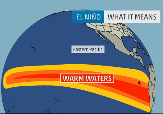
NOAA has just released an “El Niño Watch.” They’re saying that there’s a 50% chance of El Niño developing this summer or fall of 2014.
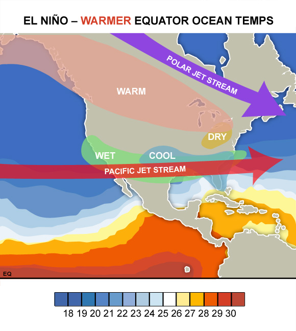
El Niño is typically good for California. If a strong El Niño actually develops, Tahoe might actually see its first good winter since 2010/11. C’mon El Niño!

El Niño also likely means less Hurricanes, which is nice.
“This could be a substantial event and I think we’re due. And I think it could have major consequences.” – Kevin Trenberth, a senior scientist at the National Center for Atmospheric Research
| EL NIÑO/SOUTHERN OSCILLATION (ENSO) |
| DIAGNOSTIC DISCUSSION |
| issued by CLIMATE PREDICTION CENTER/NCEP and the International Research Institute for Climate and Society |
| 6 March 2014 |
|
ENSO Alert System Status: El Niño Watch
|
|
Synopsis: ENSO-neutral is expected to continue through the Northern Hemisphere spring 2014, with about a 50% chance of El Niño developing during the summer or fall. ENSO-neutral continued during February 2014, with below-average sea surface temperatures (SST) continuing in the eastern equatorial Pacific Ocean and above-average SSTs increasing near the International Date Line (Fig. 1). Overall, the weekly Niño indices were variable during the month, with most indices remaining less than -0.5oC (Fig. 2). A significant downwelling oceanic Kelvin wave increased the oceanic heat content (Fig. 3) and produced large positive subsurface temperature anomalies across the central and east-central Pacific (Fig. 4). In addition, toward the end of the month, strong low-level westerly winds re-appeared over the western equatorial Pacific. Convection was suppressed over western Indonesia and the central equatorial Pacific (Fig. 5). Collectively, these atmospheric and oceanic conditions reflect ENSO-neutral.
The model predictions of ENSO for this summer and beyond are relatively unchanged from last month. Almost all the models indicate that ENSO-neutral (Niño-3.4 index between -0.5oC and 0.5oC) will persist through the rest of the Northern Hemisphere spring 2014 (Fig. 6). While all models predict warming in the tropical Pacific, there is considerable uncertainty as to whether El Niño will develop during the summer or fall. If westerly winds continue to emerge in the western equatorial Pacific, the development of El Niño would become more likely. However, the lower forecast skill during the spring and overall propensity for cooler conditions over the last decade still justify significant probabilities for ENSO-neutral. The consensus forecast is for ENSO-neutral to continue through the Northern Hemisphere spring 2014, with about a 50% chance of El Niño developing during the summer or fall (click CPC/IRI consensus forecast for the chance of each outcome). This discussion is a consolidated effort of the National Oceanic and Atmospheric Administration (NOAA), NOAA’s National Weather Service, and their funded institutions. Oceanic and atmospheric conditions are updated weekly on the Climate Prediction Center web site (El Niño/La Niña Current Conditions and Expert Discussions). Forecasts for the evolution of El Niño/La Niña are updated monthly in the Forecast Forum section of CPC’s Climate Diagnostics Bulletin. The next ENSO Diagnostics Discussion is scheduled for 10 April 2014. To receive an e-mail notification when the monthly ENSO Diagnostic Discussions are released, please send an e-mail message to:ncep.list.enso-update@noaa.gov. |
| Climate Prediction Center National Centers for Environmental Prediction NOAA/National Weather Service College Park, MD 20740 |
