
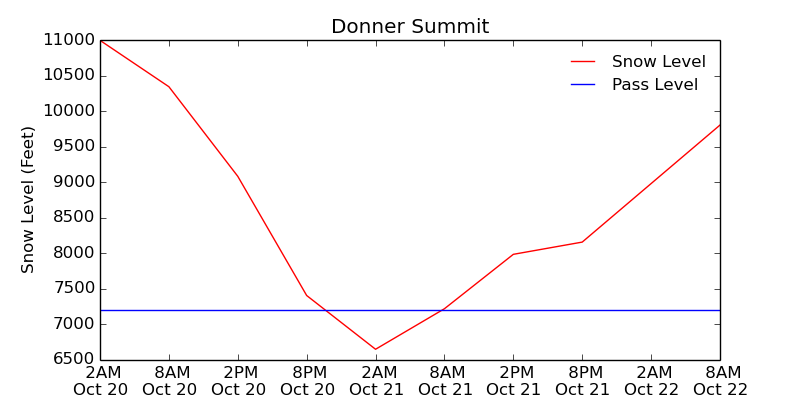
Lake Tahoe, California is expecting it’s 3rd snowstorm of the 2014/15 winter season today. Snow levels will be as low as 6,000-feet tonight in Tahoe.
The wind will be ripping along the lake today as well. So many people are surfing Tahoe now, that we’re going to start having Lake Tahoe surf forecasts. Count this as our first. If you’re in Tahoe, grab your board and go have a look today. NOAA is calling for 2-4 foot waves today in Lake Tahoe.

Unfortunately, the surf is looking better than the snow from this storm. Snowfall totals will be very light.
NOAA:
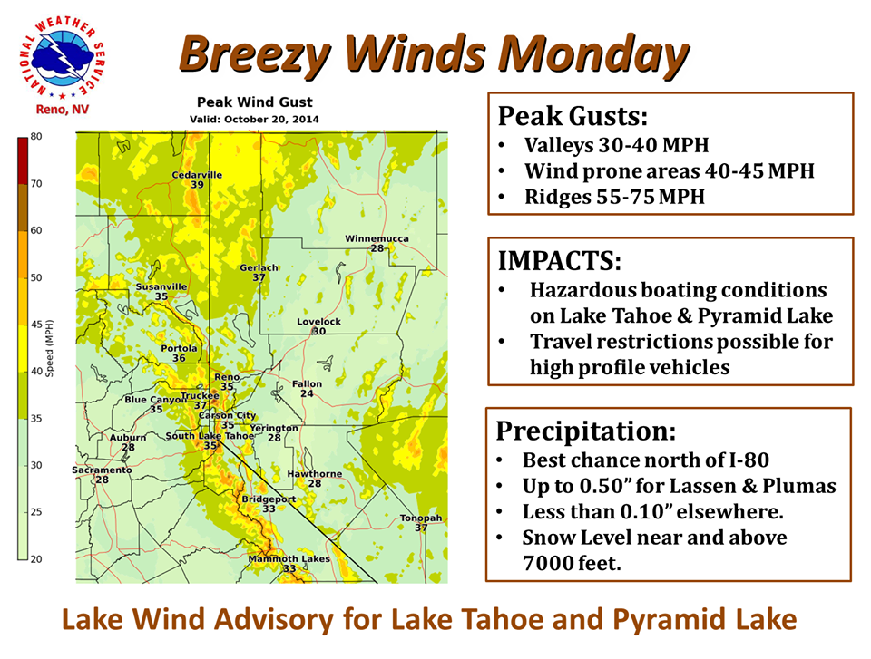
Low pressure will move through northern California and northwest Nevada on Monday. This will produce gusty winds and hazardous boating conditions for Tahoe and Pyramid where a Lake Wind Advisory is in effect.
In addition to the winds, the best chance for rain and high elevation snow is north of Interstate 80 from Monday afternoon to early Tuesday morning. Rainfall amounts up to 0.50 inch are possible in Lassen and Plumas Counties, with less than 0.10 inch elsewhere. Snow levels will remain near and above 7000 feet, but could briefly drop as low as 6000-6500 feet late Monday night and early Tuesday morning. – NOAA

NOAA Lake Wind Advisory for Tahoe:
URGENT - WEATHER MESSAGE
 NATIONAL WEATHER SERVICE RENO NV
 240 AM PDT MON OCT 20 2014

 GREATER LAKE TAHOE AREA-
 INCLUDING THE CITIES OF...SOUTH LAKE TAHOE...INCLINE VILLAGE
 240 AM PDT MON OCT 20 2014

 A LAKE WIND ADVISORY FOR LAKE TAHOE REMAINS IN EFFECT FROM 11 AM
 THIS MORNING TO 11 PM PDT THIS EVENING.

 * WINDS: SOUTHWEST 15 TO 25 MPH WITH GUSTS TO 35 MPH.

 * WAVE HEIGHTS: 2 TO 4 FEET.

 * SMALL BOATS WILL BE PRONE TO CAPSIZING AND SHOULD REMAIN OFF
   LAKE WATERS UNTIL CONDITIONS IMPROVE.