NOAA has issued a Winter Storm Warning for California tomorrow that is calling for 1-2 feet of snow above 7,500′.
This is California’s first Winter Storm Warning of the season!
* SNOW ACCUMULATIONS...6 TO 12 INCHES POSSIBLE ABOVE 6500 FEET
  WITH 1 TO 2 FEET OF SNOW ABOVE 7500 FEET. SNOW ACCUMULATIONS OF
  UP TO 3 INCHES POSSIBLE DOWN TO 5500 FEET SUNDAY EVENING.
  - NOAA Reno, NV today
Snow levels are forecast to drop to pass level (7,200′) at 2am on Sunday morning and will continue to drop to as low as 6,000′ on Sunday.
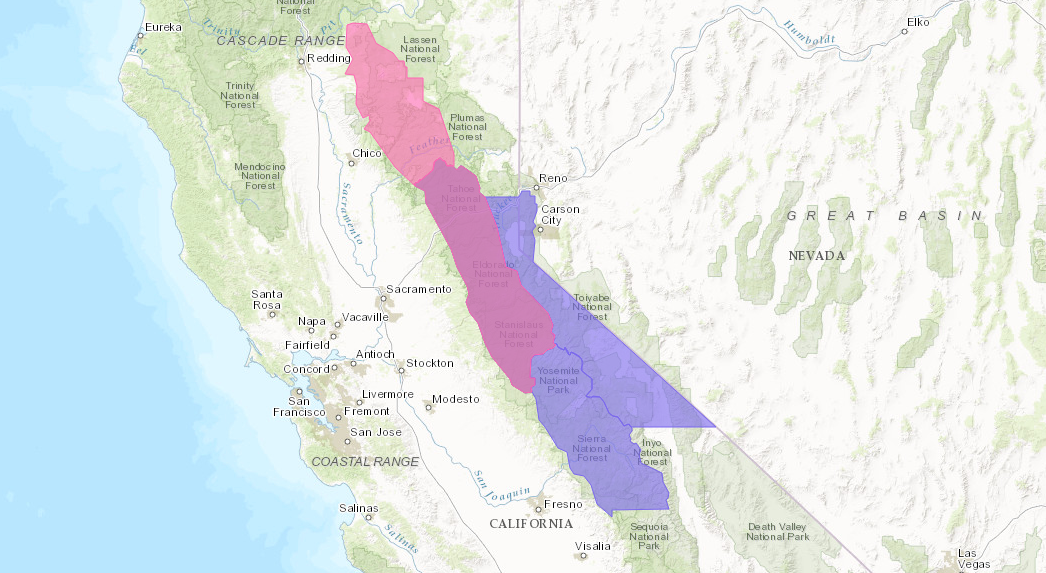
NOAA has also issued Winter Weather Advisories calling for 6-18″ of snow for huge swaths of the Sierra Nevada mountains including Lake Tahoe, Yosemite, Mammoth, Kings Canyon, & more (see map below).
This should help California ski resorts get open this season.
- Mt. Rose Ski Tahoe, NV was planning to open on Monday, but have since canceled those plans.
- Mammoth, CA plans to open on November 10th.
- Squaw Alpine, CA plans to open on November 11th.

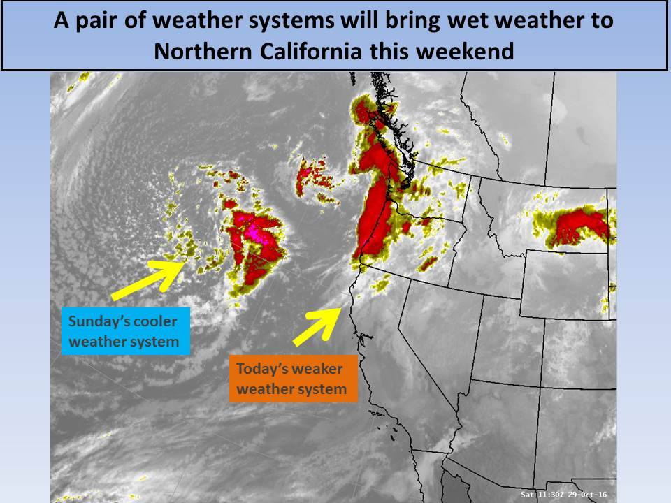
“Scattered showers will be possible across Interior Northern California today with heavier precipitation likely in Shasta county and the Coastal Range. A colder Pacific storm system will move through Sunday into Sunday night bringing more widespread precipitation with heavy amounts in the foothills and mountains. A Winter Storm Warning is in effect for the higher elevations of Western Plumas county and the Northern Sierra Nevada Sunday into Sunday night for heavy snow and strong winds above 6000 to 6500 feet. Breezy to windy conditions also possible in the Central Valley Sunday along with a threat of isolated thunderstorms. Another Pacific storm is expected later Monday into Tuesday but looks to be weaker than the one on Sunday.” – NOAA Sacramento, CA today
WINTER STORM WARNING for CALIFORNIA:
URGENT - WINTER WEATHER MESSAGE...CORRECTED
NATIONAL WEATHER SERVICE SACRAMENTO CA
545 AM PDT SAT OCT 29 2016

...HEAVY MOUNTAIN SNOW AND STRONG GUSTY WIND EXPECTED SUNDAY INTO
SUNDAY NIGHT...

.COLD LOW PRESSURE FROM THE GULF OF ALASKA WILL MOVE THROUGH
SUNDAY INTO SUNDAY NIGHT BRINGING A PERIOD OF HEAVY SNOW AND
STRONG WIND TO THE MOUNTAINS OF EASTERN SHASTA AND WESTERN
PLUMAS, INCLUDING LASSEN PARK, AND THE NORTHERN SIERRA NEVADA.
MOTORISTS TRAVELING THROUGH THESE AREAS SUNDAY SHOULD BE PREPARED
FOR HAZARDOUS WINTER DRIVING CONDITIONS. CARRY CHAINS AND EXPECT
TRAVEL DELAYS. SNOW IS EXPECTED TO DECREASE LATE SUNDAY NIGHT INTO
MONDAY MORNING.

WEST SLOPE NORTHERN SIERRA NEVADA-
INCLUDING THE CITY OF...BLUE CANYON

...WINTER STORM WARNING IN EFFECT FROM 8 AM TO 11 PM PDT SUNDAY
ABOVE 6500 FEET...

THE NATIONAL WEATHER SERVICE IN SACRAMENTO HAS ISSUED A WINTER
STORM WARNING FOR HEAVY SNOW AND STRONG WIND ABOVE 6500
FEET...WHICH IS IN EFFECT FROM 8 AM TO 11 PM PDT SUNDAY. THE
WINTER STORM WATCH IS NO LONGER IN EFFECT.

* MAIN IMPACTS: SLICK ROADS AND REDUCED VISIBILITY DUE TO HEAVY
  SNOW AND STRONG WIND. TRAVEL DELAYS LIKELY AND CHAIN
  RESTRICTIONS PROBABLE.

* OTHER IMPACTS...WINDS GUSTING TO 60 MPH THROUGH PASSED AND OVER
  HIGHER TERRAIN REDUCING VISIBILITY SIGNIFICANTLY AND CAUSING
  DANGEROUS DRIVING CONDITIONS.

* CONFIDENCE...HIGH

* TIMING...SUNDAY INTO SUNDAY NIGHT...HEAVIEST SUNDAY AFTERNOON.

* LOCATIONS...TRANS SIERRA NEVADA PASSES INCLUDING INTERSTATE 80
  AND HIGHWAY 50 ABOVE 6500 FEET.

* SNOW ACCUMULATIONS...6 TO 12 INCHES POSSIBLE ABOVE 6500 FEET
  WITH 1 TO 2 FEET OF SNOW ABOVE 7500 FEET. SNOW ACCUMULATIONS OF
  UP TO 3 INCHES POSSIBLE DOWN TO 5500 FEET SUNDAY EVENING.

PRECAUTIONARY/PREPAREDNESS ACTIONS...