This year’s first winter storm is on track for Lake Tahoe and all of the Sierra Nevada mountains of California this weekend.
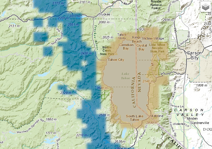
NOAA has extended the Winter Storm Watch for Sunday and Monday that it issued yesterday to include the northern Sierra Nevada mountains including Lake Tahoe.
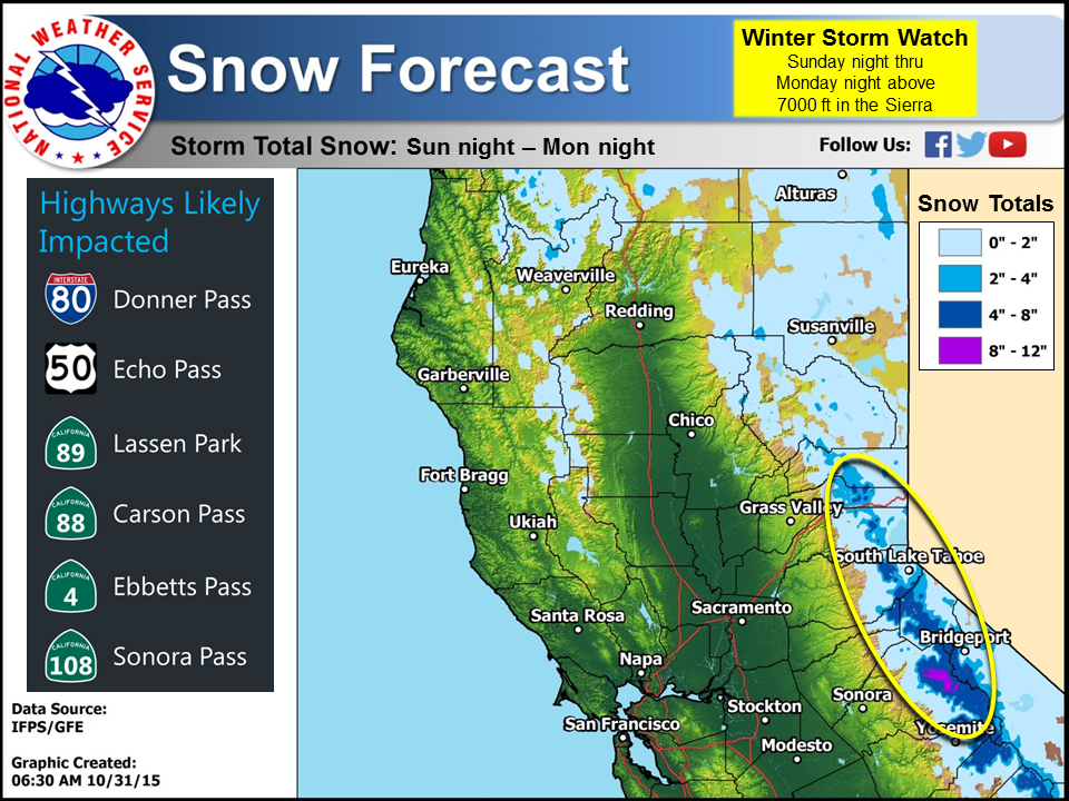
NOAA is forecasting 4-7″ of snowfall with up to a Foot of Snow on the highest peaks of the Sierra Crest. Snow levels will start out around 9,000-feet before dropping down to 5,000-feet by Monday.
* SNOW ACCUMULATIONS: 4 TO 7 INCHES AT PASS LEVELS...UP TO A
  FOOT OVER HIGHER PEAKS. - NOAA Reno, NV
Be careful out there if driving during this storm.
Snow is forecast on Sunday and Monday for:
- Donner Pass (hwy 80)
- Echo Pass (hwy 50)
- Lassen NP (hwy 89)
- Carson Pass (hwy 88)
- Ebbetts Pass (hwy 4)
- Sonora Pass (hwy 108)
- Tioga Pass (hwy 120)

“A powerful cold front will push through the Sierra and western Nevada with gusty winds through Sunday. Choppy conditions are expected on both Lake Tahoe and Pyramid Lake this weekend. Widespread rain and high elevation snow is expected for Sunday night into Monday morning. Anyone planning travel over the Sierra this weekend should prepare for winter travel conditions and pack winter clothing for their trip.” – NOAA Reno, NV
Tioga Pass and Sonora Pass most likely will close during this storm. We gotten word that Tioga Pass will close at 4pm on Sunday, possibly for the season. Up to 16″ of snow is forecast for Tioga Pass.
URGENT - WINTER WEATHER MESSAGE
NATIONAL WEATHER SERVICE HANFORD CA
227 AM PDT SAT OCT 31 2015

-SIERRA NEVADA FROM YOSEMITE TO KINGS CANYON-

...WINTER STORM WATCH NOW IN EFFECT FROM SUNDAY EVENING THROUGH
MONDAY EVENING ABOVE 7000 FEET...

* HAZARD TYPES...HEAVY SNOW.

* ACCUMULATIONS...8 TO 16 INCHES ABOVE 7000 FEET. - NOAA Hanford, CA
NOAA’s WINTER STORM WATCH for NORCAL TODAY:
URGENT - WINTER WEATHER MESSAGE
NATIONAL WEATHER SERVICE SACRAMENTO CA
440 AM PDT SAT OCT 31 2015

...SIGNIFICANT EARLY SEASON SNOW POSSIBLE LATE SUNDAY NIGHT
THROUGH MONDAY EVENING FOR THE NORTHERN SIERRA NEVADA MOUNTAINS...

.A COOL STORM SYSTEM WILL SPREAD PRECIPITATION ACROSS THE AREA BY
LATE SUNDAY WITH POTENTIALLY THE FIRST SIGNIFICANT SNOWFALL OF
THE SEASON. SIERRA NEVADA MOUNTAIN SNOW IS EXPECTED TO BEGIN LATE
SUNDAY NIGHT AND CONTINUE THROUGH MONDAY. THIS STORM IS FORECAST
TO BRING SNOWFALL AMOUNTS AROUND 4 TO 7 INCHES TO THE SIERRA
PASSES AND UP TO A FOOT TO HIGHER TERRAIN SOUTH OF I-80. SNOW
LEVELS WILL INITIALLY BE AROUND 9000 FEET DURING THE DAY SUNDAY...
DROPPING TO PASS LEVELS BY LATE EVENING WITH SNOW ACCUMULATING
AFTER MIDNIGHT. THE HEAVIEST SNOW IS EXPECTED MONDAY MORNING. THE
SNOW WILL BECOME MORE SHOWERY THROUGH MONDAY AFTERNOON AND
EVENING WITH SNOW LEVELS DROPPING TO AROUND 5000 FEET.

-WEST SLOPE NORTHERN SIERRA NEVADA-

...WINTER STORM WATCH REMAINS IN EFFECT FROM SUNDAY EVENING
THROUGH MONDAY EVENING...

* IMPACTS: SIERRA TRAVELERS MAY EXPERIENCE VERY LONG DELAYS.
  CHAIN RESTRICTIONS PROBABLE.

* CONFIDENCE: HIGH CONFIDENCE SNOW WILL OCCUR ABOVE 7000 FEET.
  MEDIUM CONFIDENCE IN TIMING AND AMOUNTS.

* TIMING: SNOW LEVELS STARTING AROUND 9000 FEET SUNDAY
  AFTERNOON...REACHING PASS LEVELS LATE SUNDAY EVENING...5000 FEET
  DURING THE DAY MONDAY. HEAVIEST SNOW MONDAY MORNING.

* LOCATIONS INCLUDE: DONNER PASS ON I80...ECHO SUMMIT ON HIGHWAY
  50...CARSON PASS ON HIGHWAY 88...EBBETTS PASS ON HIGHWAY 4...
  SONORA PASS ON HIGHWAY 108.

* SNOW ACCUMULATIONS: 4 TO 7 INCHES AT PASS LEVELS...UP TO A
  FOOT OVER HIGHER PEAKS.

Is this the science of meteorology, first exaggerate and dramatize the possibility, then back off half a foot per day for a few days, then you’ve got the forecast.