NOAA has release it’s official 2015/16 winter forecast for the USA. They’re sticking to their confidence in the strong El Nino affecting the USA with above average precipitation in the south and above average temperatures in the north. Lets break it down:
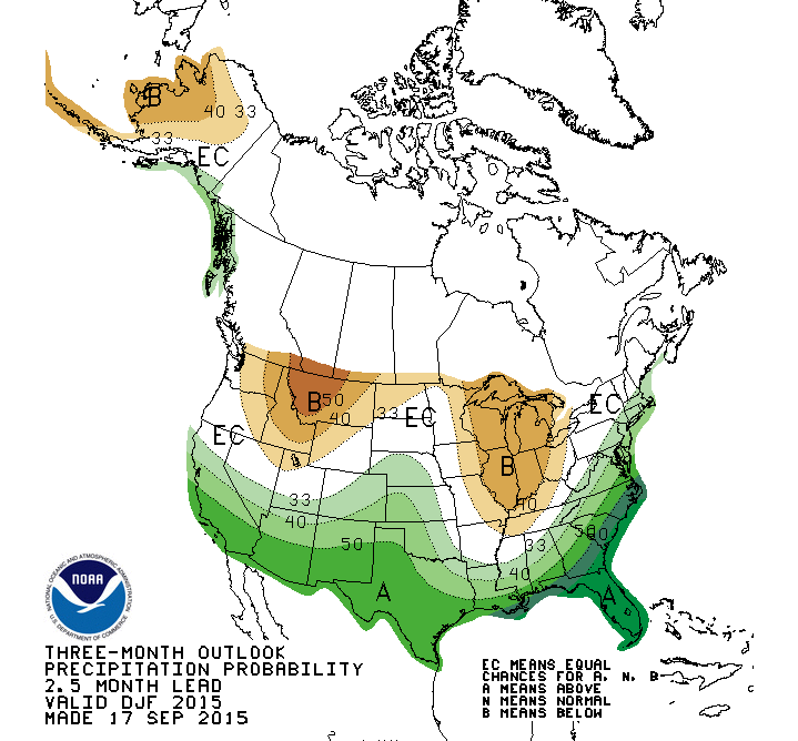
2015/16 WINTER PRECIPITATION:
NOAA’s precipitation outlook for winter 2015/16 is showing above average precipitation for the southern half of the USA including Tahoe, Colorado, Arizona, & New Mexico. Below average precipitation is forecast in the Northern Rocky Mountains and Alaska.
LOOKS GOOD FOR:
Tahoe, Mammoth, SoCal, New Mexico, Flagstaff, and Colorado.
LOOKS BAD FOR:
Washington, Idaho, Montana, and Wyoming.
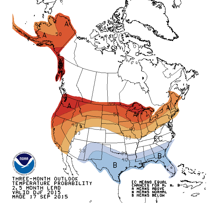
2015/16 WINTER TEMPERATURES:
NOAA’s temperature outlook for winter 2015/16 showing above average temperatures in the northern half of the USA and all of Alaska. Below average temps in the southern half of the USA.
LOOKS GOOD FOR:
New Mexico.
LOOKS BAD FOR:
This looks really bad for the Pacific Northwest, but looks bad on some level for every ski area outside of New Mexico…
OVERALL OUTLOOK FOR 2015/16:
Overall, this outlook favors New Mexico. If this outlook rings true, this is the year to head to Taos, New Mexico as they are forecast to receive above average precipitation and below average temperatures.
This forecast also looks good for southern California, but snow levels will be the issue here as El Nino often brings higher snow levels.
This outlook looks bad for Washington. They are forecast for below average precipitation and above average temperatures.
Interesting to note that that the last two el Nino events here in California were preceded by November precipitation that was well above normal, this November has seen only about one third of normal precip and the rest of the months precip looks to continue well below normal. Yet we are getting all kinds of advice to buy flood insurance etc. The commonly used forecast tool known as GFS has had a very dismal record of accurate forecasts. Even the USAF which had used the GFS has signed a 1 million dollar contract with UK Met service as they feel the GFS is too unreliable! I agree with that!
Here’s last year’s NOAA forecast for the winter, also made in September:
http://snowbrains.com/noaa-201415-winter-outlook-usa-dec-jan-feb/
Doesn’t look too different from the current one, even though El Nino strength now is nearly 3x what it was a year ago.
Most years these forecasts made months in advance are fantasyland. The ones made in fall 2011 for the 2011-12 season were spectacularly bad.
El Nino/La Nina are a rare weather phenomenon that tends to persist from fall through winter, and this has some predictive value. But other factors can still have material impact, and few of those are predictable more than a couple of weeks in advance. As an example, the much abused PNW in these forecasts had almost exact average snowfall during the two biggest El Nino seasons of 1982-83 and 1997-98. When you look at all the strong El Nino months going back into the 1970’s, you get an expectation of about 85% of normal snow in most PNW areas. and 85% of 400+ inches for most of these places is still a respectable number. I would be cautious about rain incidence at the lowest elevations, but be very surprised to the extreme high rain/snow lines of 2014-15.
Conversely Taos’ expectation is about 115% of normal. That’s not enough to change the equation that it takes along time to get its steeps covered with light and dry snow. Yes, I’d say it’s a good bet in February/March. But 15% extra snowfall isn’t going to get the new Kachina lift open by Christmas. You’ll need more like 150% during November/December for that to happen.
The point of this rant is that the long term historical record of a ski resort, when it usually gets enough snow for full operation and how well the snow preserves once it is there, is still what’s most important in planning a ski destination far in advance. These long term forecasts are worth just a tiny bit in a big El Nino or La Nina season and are essentially worthless otherwise.
But the best way of all is NOT to plan far in advance. And that doesn’t just mean powder chasing a few days ahead. If you plan one or two months ahead for February or later trip, yoiu have the advantage of knowing who got the early season snow.
Better start running.. The Tony Crocker weather police is coming for you.