The Colorado Avalanche Information Center has release a Special Avalanche Bulletin for this weekend.
They are highly concerned about a weak snowpack that will exist beneath near 12” of new snow in Colorado this weekend. If you’re thinking of skiing Colorado this weekend or early this week, please read the bulletin below and visit the Colorado Avalanche Information Center for more information.
***
| Avalanche Special in Effect through 11/17/2013 4:00 PM |
| A significant winter storm will impact our mountains this weekend dropping a foot or more of snow onto a weak snowpack. You can expect very touchy conditions and a widespread avalanche cycle on slopes currently harboring Persistent Slabs resting on weak faceted snow. Extra caution is required this weekend. Don’t let the fresh snow blind you to the very real and rapidly increasing avalanche danger. |
| Highlights |
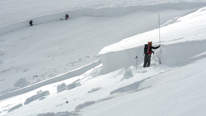
| Some heavy snow is impacting most mountain areas this weekend, and you can expect avalanche danger to rise very quickly. The current snowpack structure won’t be able to support this rapid and significant loading. The snow will come in with lots of wind, so fresh Wind Slabs are a primary concern this afternoon for the rest of the weekend. Persistent slabs area also a problem, and will become more likely with this freash loading. The most problematic slopes are east-facing and above treeline where early season snowfall has drifted into hard slabs that are sitting atop a weak base of faceted snow. Recent activity includes scary remotely triggered slides in the Northern San Juan Mountains. This problem exists statewide, but the largest avalanches are most likely in portions of the state with the deepest snowpack (up to 40 inches): Northern San Juan Mountains, northern front Range, and the Buffalo Pass area near Steamboat. Most avalanches will be on the smalll side, but even a short ride in a shallow avalanches could be rough as it drags you through rocks and trees. We will update the statewide avalanche conditions as necessary. Weather products are updated twice daily. Zone avalanche and snowpack discussions will start around mid-November. |
| Weather Discussion |
| The deepest pool of moisture is currently sweeping over the western mountains of Colorado. Snowfall will begin to intensify later this afternoon, with peak intensity occuring overnight. The heaviest snow will shift further north into the Central and Northern Mountains, which should pick up another 4 to 10 inches. The downside is the very strong westerly winds accompanying this storm, which will make for blizzard-like conditions. But, hard to complain about a bunch of new snow. The system moves rather quickly east with snowfall ending early Sunday morning. Temperatures warm slowly on Sunday afternoon as high pressure makes a return to Colorado for early next week. Weak zonal flow will dominate through Tuesday before the nexy storm system makes it to Colorado from the northwest.CAIC computer model forecasts update four times a day. If you are going into the Colorado high country use our weather stations by zonepage to check current conditions. |
| Snowpack & Avalanche Discussion |
| The significant winter storm impacting our mountains is quickly increase the avalanche danger. Our current snowpack consists of early season snow that has drifted into hard Persistent Slabs resting on top of weak faceted snow. This structure will not be able to support the new load that will arrive over the weekend, and you can expect a good avalanche cycle if the weather forecast verifies.The most problematic slopes are steep north to east-facing slopes near and above treeline. In most areas, the snowpack is not deep nor contiguous enough to produce large avalanches, but even small slides can be deadly. Areas in the Northern San Juan Mountains, the northern Front Range, and the Buffalo Pass area have deeper snowpacks and it’s possible to trigger larger slides in these locations. Any ride in an avalanche right now would be ugly as you get dragged across the rocks and bare ground. Shallowly-buried obstacle are a real concern. There have been avalanche accidents in Colorado every month of the year. Avalanches in the early fall are less frequent than in mid-winter, but they are possible once snow begins to accumulate. In the fall, it is easy to discount the amount of snow on the ground. Grass and brush sticking out of the snow surface is misleading. You should start thinking about avalanches any time you have snow resting on a steep slope. Remember, all you need is a slab resting on a weak layer of snow to create conditions that can produce avalanches. The ground can easily act as a bed surface, even if it is only a few inches below the snow surface. You can look here for observations of snow conditions and reports of avalanches any time of the year. We also want to hear your reports on backcountry conditions and avalanche observations, so please send us your observations.Persistent Slab Avalanches
Early season snowfall facets rapidly on the ground. This leaves thin layers of very weak snow. When newer snow falls on top, it can create a sensitive slab on top of the faceted snow. This is the classic recipe for a Persistent Slab, even if the ingredients are much thinner than what we think of during mid-winter. Wind-drifted snow creates a thinker, stiffer slab and can create dangerous avalanches. Areas with shallow snow may be very close to deep drifted areas. It may be quite easy to move from a very safe area to a very dangerous area without traveling very far. Those drifted areas can offer the best early-season riding, which attract recreators to potentially problematic areas. Here are two reports about early-season persistent slabs created by wind drifting: Jones Pass in 2007 and Berthoud Pass in 2005. Storm Slabs, Wind Slabs, and Loose-Dry Avalanches Most avalanches happen during or right after a snow storm. Every time new snow falls and the wind moves it through the terrain, these avalanches are possible. New snow layers often have a hard time sticking to hard, icy surfaces, so a snow storm can produce lots of small avalanches if it falls onto an old snowfield. Even small avalanches are dangerous if they can push you off a cliff, or into rocks, trees, or a gulley. The best way to manage these avalanches in the fall is to have a current weather forecast, recognize when there is enough new snow to produce storm avalanches, and select terrain that minimizes your exposure to the risk (avoid areas where there were old snowfield, wind pillows along ridgelines, cross-loaded features like rock outcrops and subridges). As an example, a new-snow avalanche produced afatal accident in 2011. |
One thought on “***Special Avalanche Hazard Warning in Colorado This Weekend***”