 Weather


A wet winter can bury a summit and rain out its base—a contrast at the heart of the SnowBrains 2026-27 ski season forecast. A warm winter can still deliver weeks of powder. Those distinctions will matter in 2026–27, as a powerful El Niño reshapes the odds across North American ski country.
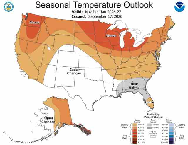
Our strongest positive lean is for California’s high Sierra, followed by the mountains of southern Utah and southern Colorado. Interior western Canada and the northern U.S. Rockies face a less favorable combination of warmth and reduced moisture. Coastal British Columbia and the Cascades are more complicated: enough moisture could overcome some of the warmth, especially higher up. The Northeast’s problem is getting storms and cold air to arrive together.
The setup: strong signal, imperfect road map
This is no longer just a model predicting warm Pacific water. NOAA’s October observations show the ocean and atmosphere acting together: weakened trade winds, eastward-shifted tropical thunderstorms, and substantial warmth beneath the surface, with sea surface temperatures running more than 4°C (7°F) above normal in parts of the eastern equatorial Pacific. El Niño is underway, and still strengthening. NOAA’s latest strength forecast gives an 83% chance it will become the strongest El Niño on record during October through December, surpassing every event since 1950, and expects a strong-to-very strong El Niño to persist through January–March 2027.
What a Very Strong El Niño Means for the 2026-27 Ski Season Forecast
That tropical heating tends to extend the Pacific jet toward California and the southern United States. September’s North American multi-model guidance supports a wetter southern storm corridor, with a drier signal farther inland to the north. But precipitation is only the first ingredient. How much falls as snow and how much survives between storms depends a ton on temperature, elevation, and timing.
There is also an important mismatch with past giants. NOAA’s September 17 discussion notes a negative Pacific Decadal Oscillation, a different arrangement of North Pacific ocean temperatures than the positive PDO pattern that accompanied 1982–83, 1997–98, and 2015–16. The main patch of unusually warm North Pacific water is also displaced fairly westward, which could soften some familiar West Coast effects. It gives us reason to leave room for Northwest surprises, but not to predict a cold winter. The interesting ENSO-PDO combination here makes predictability this far out quite difficult.
Climate Change and the Rain-Snow Line in the 2026-27 Ski Season Forecast
We also cannot replay an old winter in today’s climate. Background warming from climate change puts a lot more pressure on terrain where storms already hover near freezing. Higher mountains can still turn extra moisture into snow. That is why we’re more confident in a wet pattern than in widespread powder. As we head into this season, remember: more storms don’t necessarily mean more snow. We learned that the hard way last season, when most regions saw plenty of moisture, but frustrating temperatures brought a lot of rain.

How to Read Our 2026-27 Ski Season Forecast by Region
How to read the following regional calls: These are qualitative leans for mountain snowfall, not precise resort totals. Confidence describes the snowfall call, not certainty that El Niño will occur. “Near normal” means no compelling directional edge; certainly not a promise of an ordinary winter.
Alaska: Southcentral and Southeast tell different stories
Snowfall lean: near to below normal in Southcentral; mixed in Southeast. Confidence: low.
The warmer outlook and mainland drying tendency make us cautious about Alyeska and the Chugach. Upper elevations can still capture major Gulf of Alaska storms, while lower mountains get more rain. Southeast has a wetter lean in NOAA’s official guidance, but also pronounced warmth: Eaglecrest needs the freezing level to cooperate. The distinction is between moisture reaching the mountains and usable snow reaching the bottom of the lifts.
British Columbia: better prospects up high than down low
Snowfall lean: near normal on the upper coast; slightly below inland. Confidence: low.
Whistler’s alpine has a plausible path to a respectable season, even if lower runs struggle with rain and thaws. Its published record lists 1,257 centimeters in the very strong 2015–16 El Niño, above its stated 1,040-centimeter average. That is a counterexample, but it doesn’t guarantee an average or above-average season. For Revelstoke, Whitewater, and Big White, we lean toward reduced snowfall replenishment. Colder upper terrain offers some protection from rain, but not from storms tracking elsewhere.
Canadian Rockies: cold enough, but potentially short on storms
Snowfall lean: slightly below normal. Confidence: moderate.
Canadian climate guidance and September’s North American models support a warmer, drier tendency here. Lake Louise, Sunshine, and Marmot Basin should nevertheless retain an important advantage: a mild midwinter day by local standards can still be well below freezing. Our concern is reduced accumulation, not persistent rain across the terrain. Compared with coastal destinations, the Rockies offer better protection against warm storms; compared with their own normal winter, the snowfall outlook is less encouraging.
Washington: caution, not a canceled winter
Snowfall lean: near to slightly below normal, with larger risks down low. Confidence: low.
Our check of Mt. Baker’s records found 657, 648, and 622 inches in the three historical giant El Niños – all within 5% of its calculated 1991–2020 winter average. That small sample argues against an automatic Northwest wipeout. The more convincing concern is snow level and retention, especially around Snoqualmie Pass. Upper terrain at Crystal and Stevens has more temperature margin. As 2015–16 demonstrated, a wet winter can compensate for warmth, then lose snow quickly in spring. We anticipate the biggest issue for the PNW will be high snow levels and frustratingly warm, wet storms when they do arrive.
Oregon: do not simply copy Washington’s forecast
Snowfall lean: near normal overall, with some higher-elevation upside. Confidence: low.
NOAA explicitly extends its later-winter wet signal into central Oregon, potentially farther north. That gives Mt. Bachelor a more encouraging moisture setup than the northern interior Rockies. We lean near to slightly above normal on its higher terrain, while keeping the broader state call closer to neutral. Mount Hood can also benefit when Pacific storms reach far enough north. Lower slopes remain vulnerable to warm storms; a wet map alone doesn’t mean Oregon’s ski season will be good.
California: the clearest upside is in the high Sierra
Snowfall lean: above normal at higher Sierra elevations. Confidence: moderate.
Mammoth and higher Tahoe terrain has the best overlap of enhanced moisture and cold enough temperatures to use it. The winter model signal supports optimism, especially for building a substantial midwinter base. But expect elevation contrasts: deep upper-mountain snow can accompany rain lower down. Southern California’s mountains also have moisture upside, but snow levels are less certain.
There is no sound basis for promising a record. In the three giant El Niños, Mammoth’s Main Lodge totals ranged from 362 to 546 inches. Favorable circulation raises the opportunity; individual storms still determine the outcome.
Idaho: a modest northern disadvantage
Snowfall lean: slightly below normal, particularly north. Confidence: moderate.
The combination of northern-interior drying and warmth makes Schweitzer and nearby northern Idaho mountains less favored than the southern storm corridor. Brundage and Tamarack also warrant a cautious lean. Sun Valley sits closer to the transition zone, where the precipitation signal weakens. The signal supports a modest deficit, not a prediction of catastrophic shortage. Higher, sheltered terrain should fare better between refreshes than lower, sunny slopes.
Wyoming: the Tetons sit near the boundary
Snowfall lean: near to slightly below normal in the Tetons. Confidence: low.
Jackson Hole and Grand Targhee lie near the southern edge of the less favorable northern pattern. The signal is weaker here than farther north, so a confident dry forecast would overreach. Their upper mountains should remain cold enough for snow through much of midwinter; the bigger concern is how much moisture reaches the range. Southern Wyoming, including the Snowy Range, sits closer to neutral. This is a historically transitional region, where small shifts in storm tracks can outweigh the seasonal tendency.
Utah: a southern edge, not a statewide jackpot
Snowfall lean: near normal in the Wasatch; above-normal lean south. Confidence: low to moderate.
Alta, Snowbird, and the central Wasatch occupy a transition zone rather than the heart of El Niño’s wettest corridor. We do not see enough evidence to promise an unusually snowy winter there. High elevation still helps protect snow quality and coverage during warmer periods. Farther south, Brian Head and Eagle Point align better with the favored moisture pattern. Their positive lean is stronger than the Wasatch’s, though long dry breaks remain possible.
Colorado: favor the south, resist the statewide headline
Snowfall lean: above normal in parts of the southern mountains; near normal central and north. Confidence: low to moderate.
Wolf Creek and the San Juans have Colorado’s most encouraging setup, with a modest advantage to southern storm tracks. The case is weaker for the I-70 corridor and northern mountains; Steamboat carries a slight downside risk. Importantly, a wet forecast east of the Continental Divide does not automatically translate into deep snow at western resorts. Storm direction matters. Colorado’s altitude offers useful protection from rain, but it can’t create moisture when the favored flow misses a mountain range.
Northeast: storms need a supply of cold air
Snowfall lean: near to below normal, with elevated thaw risk. Confidence: low.
The southern jet can feed East Coast storms, and current guidance favors increased moisture near the Atlantic coast. That doesn’t automatically mean snow for the Adirondacks, Green Mountains, or northern New England. Tracks too far inland bring rain; tracks too far offshore miss the mountains. Higher northern terrain retains the better temperature cushion. North Atlantic blocking can improve the cold-air setup, but its timing remains a major uncertainty. Expect excellent stretches, but don’t assume durable natural coverage everywhere.
How the 2026-27 snowfall forecast is likely to unfold
November–December: Opening conditions remain especially uncertain. Warmth creates more risk at rain-prone bases and during marginal snowmaking windows; early southern storms could still build substantial high-elevation bases.
January–March: This is the main window for the southern moisture advantage to pay off. We don’t predict every month will be wet, or that the north cannot win a several-week stretch. Research shows El Niño’s western influence varies within winter; one reason a precise month-by-month powder calendar would be false precision.
Spring: The High Sierra and southern Rockies snowpack is better set up to carry a strong season forward. Warmer spring guidance raises retention concerns farther north and at lower elevations. This outlook does not predict closing dates.
Moving clusters of tropical thunderstorms (MJO) and changes in the polar vortex can rearrange winter weather for weeks. They matter for updates, but do not supply a reliable October calendar of January powder days.
The Bottom Line on the 2026-27 Ski Season Forecast
Favor the high southern mountains, stay flexible in the Northwest, and treat the Northeast as a storm-by-storm proposition. These are departures from each region’s own climate, not a ranking of absolute snowfall: a below-average winter at a very snowy mountain can still deliver more snow than an above-average winter elsewhere. Remember that predictability this far out is extremely difficult. Our 2026-27 ski season forecast offers directional “best guesses” based on available information but should not be treated as guarantees. Stay tuned for consistent regional SnowBrains forecasts throughout the season for more detailed, storm-specific information.


“the PDO is not–in itself– a primary global climate driver. It is, instead, a broadly useful statistical construct–an index, based on spatial statistics of North Pacific sea surface temperatures (SST) that helps to characterize decadal-scale variations in North Pacific ocean and climate conditions.” Dr Swain in current Weather West post:
https://weatherwest.com/