The “Pineapple Express” Atmospheric River we’ve been waiting for will be impacting California today. 1-3 feet of snow is forecast above 8,000-feeet, 6-12″ above 7,000-feet, 3-6″ below 7,000-feet.
* SNOW ACCUMULATIONS: 1 TO 3 FEET ABOVE 8000 FEET...INCLUDING
  CARSON PASS AND THE MOUNT ROSE HIGHWAY SUMMIT. 6 TO 12 INCHES
  BETWEEN 7000 AND 8000 FEET...INCLUDING DONNER PASS AND ECHO
  SUMMIT. 3 TO 6 INCHES BELOW 7000 FEET. - NOAA Reno, NV today
Snow levels will start out above 8,000-feet tonight before dropping as low as 4,000-feet by Sunday. Winds will be howling up to 100mph during the storm.
The question is: how much of this precipitation will fall as rain before changing to all snow?
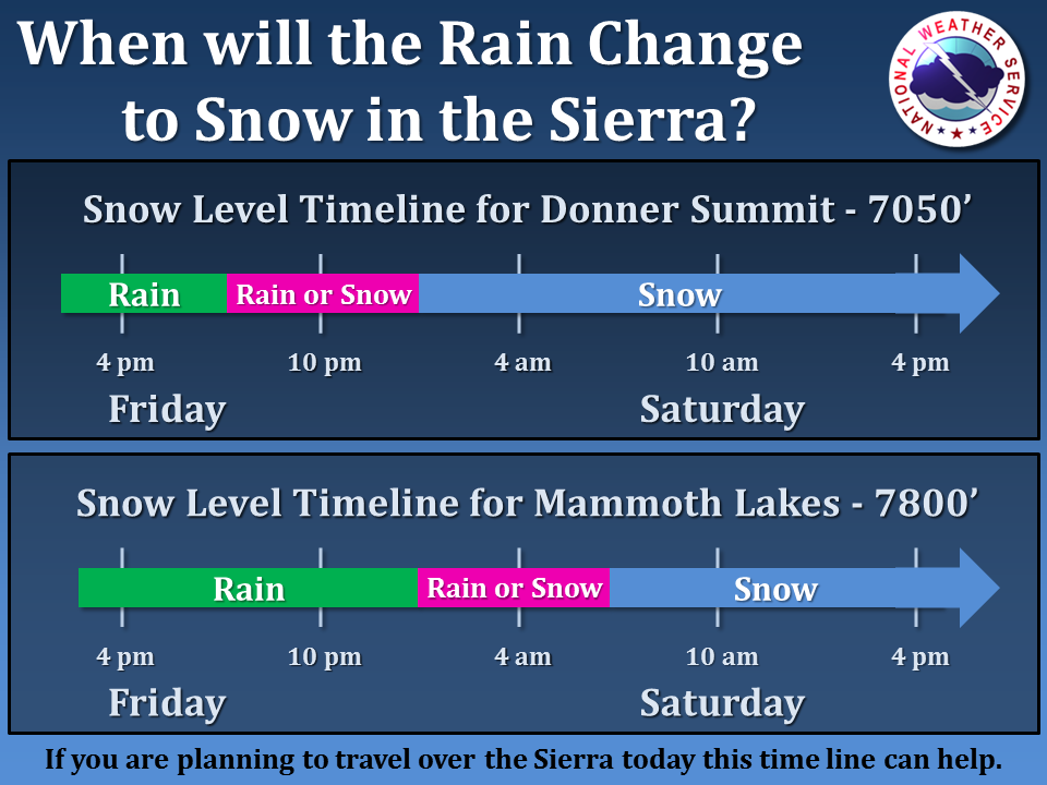

- Snow level model for Tahoe. image: noaa, today
NOAA still isn’t sure but here is what their snow level model (above) is saying for Tahoe:
- 8,000-foot snow levels for Friday morning with heavy rain below that
- 5,500-foot snow levels Friday at midnight with moderate snowfall
- 4,500-foot snow levels on Saturday with light snowfall
- 3,500-foot snow levels on Sunday with light snowfall
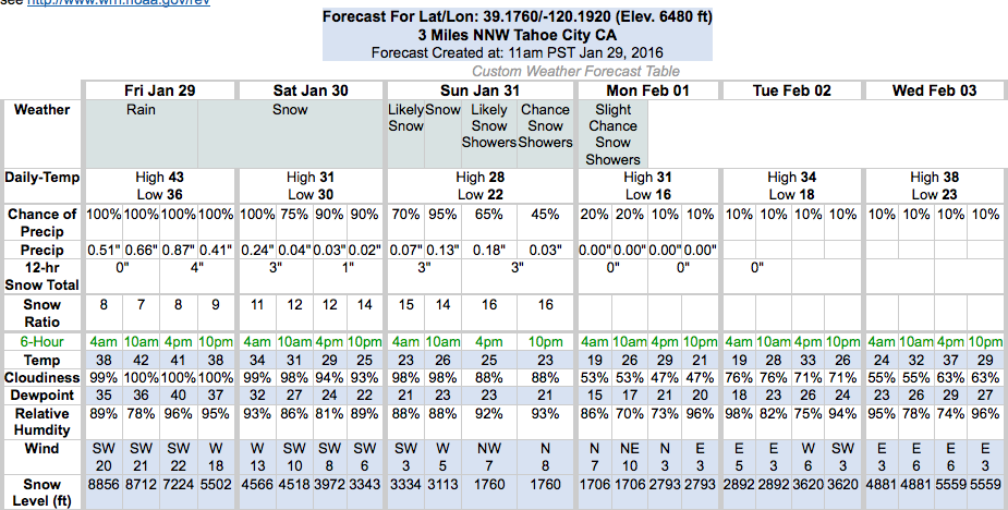
Right now, it looks like today will be warm, windy (80mph on ridge at Squaw right now), and soggy with upper mountains closed in Tahoe. Tomorrow morning will likely be windy up top with upper mountains closed and really soggy down low with a few wet inches of snow on top. Tomorrow afternoon things might open up up top at ski resorts, but maybe not due to forecast high avalanche danger. Sunday, though, might be amazing up top. Sunday could be the day.
What’s really crazy is that some forecasters are saying that we might not see any more storms in CA for about 2 weeks…
“There are no more storms on the horizon for at least the first 10 days of February.” – Bryan Allegretto/opensnow.com, today
More NOAA details on today’s storm:
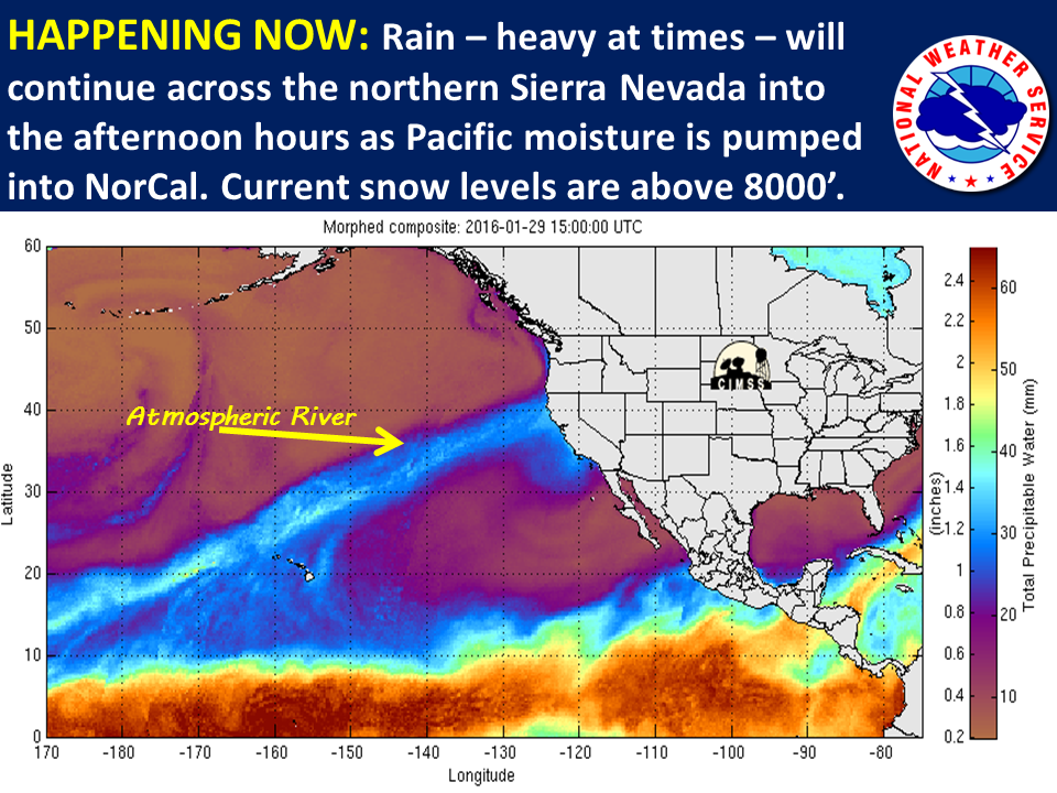
+ STORM TODAY AND SATURDAY...
LIGHT PRECIPITATION AHEAD OF THE MAIN PLUME REACHED THE NORTHERN
SIERRA AROUND 11 PM YESTERDAY EVENING. CURRENT SNOW LEVELS ARE
RUNNING AT 8000-9000 FEET IN THE TAHOE BASIN AND 7000-8000 FEET IN
LASSEN COUNTY. SOME OF THIS PRECIPITATION WILL CROSS INTO WESTERN
NEVADA THIS MORNING, BUT ONLY EXPECTING AMOUNTS LESS THAN 0.10 INCH.
THE MODELS CONTINUE TO SHOW A RAIN SHADOW DEVELOPING ACROSS MUCH OF
WESTERN NEVADA AND THE EASTERN SIERRA BY NOON, AS THE JET NOSES INTO
NORTHERN CALIFORNIA AND PRECIPITATION INTENSIFIES ALONG THE NORTHERN
SIERRA CREST. MOST LOCATIONS WILL GUST AT 45-60 MPH WITH WIND PRONE
AREAS AND FOOTHILLS GUSTING AT 60-80 MPH. WINDS AND WARM AIR ALOFT
WILL HELP RAISE AFTERNOON HIGHS INTO THE LOW 60S ACROSS WESTERN
NEVADA, WHICH COULD SET NEW RECORD HIGHS IN A FEW LOCATIONS.

MODELS HAVE CONTINUED TREND HIGHER ON LIQUID AMOUNTS ALONG THE
CREST. TOTALS COULD EXCEED 3 INCHES ALONG THE CREST, PERHAPS AROUND
4 INCHES FOR FAVORED UPSLOPE LOCATIONS AROUND PLUMAS-EUREKA STATE
PARK AND WESTERN LASSEN COUNTY. SNOW TOTALS WILL BE IMPRESSIVE
AS 1 TO 3 FEET OF HEAVY WET SIERRA CEMENT ACCUMULATE ALONG THE
CREST ABOVE 8000 FEET. TOTALS BELOW 8000 FEET WILL BE DECIDED BY
HOW QUICKLY SNOW LEVELS DROP, EITHER BY THE COLD FRONT TRACKING
SOUTH OR DOWNWARD MIXING OF COLD AIR DUE TO HEAVY PRECIPITATION.
- NOAA Reno, NV today
Moisture plume spreading toward Northern California! Heaviest precipitation expected across the Sierra Friday into Saturday morning.
Posted by US National Weather Service Sacramento California on Thursday, January 28, 2016
***
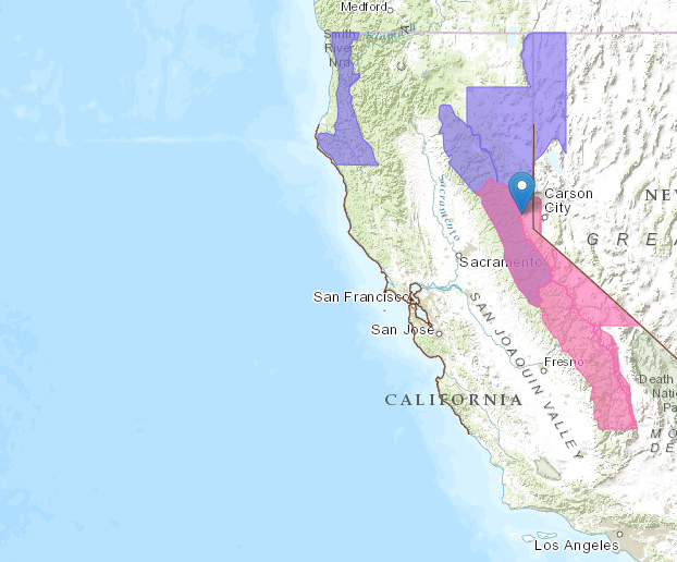
WINTER STORM WARNING for TAHOE:
URGENT - WINTER WEATHER MESSAGE
NATIONAL WEATHER SERVICE RENO NV
241 AM PST FRI JAN 29 2016

GREATER LAKE TAHOE AREA-
INCLUDING THE CITIES OF...SOUTH LAKE TAHOE...TRUCKEE...
INCLINE VILLAGE

...WINTER STORM WARNING REMAINS IN EFFECT FROM 4 PM FRIDAY TO
10 AM PST SATURDAY...

* TIMING: STRONG WINDS...RAIN AND SNOW WILL MOVE INTO THE TAHOE
  BASIN TODAY AND CONTINUE THROUGH SATURDAY MORNING. HEAVY SNOW IS
  LIKELY TONIGHT AND EARLY SATURDAY MORNING.

* SNOW LEVELS: 8000 TO 8500 FEET FRIDAY AFTERNOON...THEN LOWERING
  TO 5000 FEET BY SATURDAY MORNING.

* SNOW ACCUMULATIONS: 1 TO 3 FEET ABOVE 8000 FEET...INCLUDING
  CARSON PASS AND THE MOUNT ROSE HIGHWAY SUMMIT. 6 TO 12 INCHES
  BETWEEN 7000 AND 8000 FEET...INCLUDING DONNER PASS AND ECHO
  SUMMIT. 3 TO 6 INCHES BELOW 7000 FEET.

* WINDS: SOUTHWEST 20 TO 30 MPH WITH GUSTS TO 50 MPH IN THE
  LOWER ELEVATIONS WITH SIERRA RIDGE GUSTS NEAR 100 MPH.

* IMPACTS: DANGEROUS CONDITIONS FOR RECREATIONAL ACTIVITIES AND
  TRAVEL OVER MOUNTAIN PASSES. STRONG WINDS MAY DAMAGE DROUGHT
  STRESSED TREES WITH POWER OUTAGES POSSIBLE.
One thought on “Atmospheric River to Impact California Today | 6-36″ of Snow Forecast…”