A backcountry snowboarder was killed in a large avalanche on Mount Trelease, CO on February 14th, 2021. Below is the full report from the Colorado Avalanche Information Center. Intense reading…
Avalanche Details
- Location: Near Mount Trelease, north of Loveland Pass
- State: Colorado
- Date: 2021/02/14
- Time: 8:45 AM (Estimated)
- Summary Description: 1 backcountry snowboarder caught, partially-buried critical, killed
- Primary Activity: Backcountry Tourer
- Primary Travel Mode: Snowboard
- Location Setting: Backcountry
Number
- Caught: 1
- Partially Buried, Non-Critical: 0
- Partially Buried, Critical: 1
- Fully Buried: 0
- Injured: 0
- Killed: 1
Avalanche
- Type: HS
- Trigger: AR – Snowboarder
- Trigger (subcode): u – An unintentional release
- Size – Relative to Path: R4
- Size – Destructive Force: D3
- Sliding Surface: G – At Ground/Ice/Firm
Site
- Slope Aspect: E
- Site Elevation: 12267 ft
- Slope Angle: 35 °
- Slope Characteristic: Planar Slope
Avalanche Comments
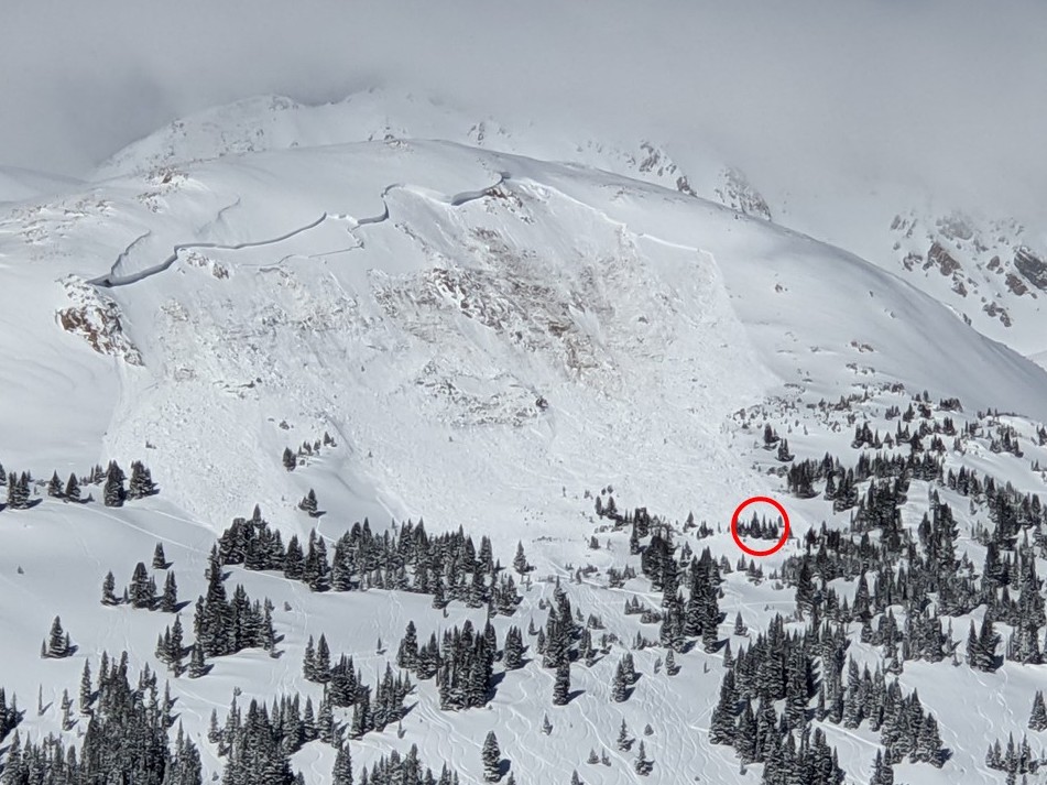
This avalanche occurred on a steep, east-facing, above-treeline slope on Mount Trelease, locally known as Pat’s Knob. The slope angle of the bed surface was generally 35 degrees, but as steep as 42 degrees in places. This was a very large, hard-slab avalanche unintentionally triggered by a snowboarder. The avalanche was large relative to the path and produced enough destructive force to bury and destroy a car or destroy a wood frame house. The crown face of the avalanche was up to 20 feet deep and 850 feet wide. The debris ran 500 vertical feet. The avalanche broke in a layer of faceted snow about 2 feet from the ground before stepping down to the ground taking the entire season’s snowpack with it (HS-ARu-R4-D3-O/G). The avalanche ran into relatively flat terrain covering tracks of riders from previous days. The force of the avalanche snapped numerous small trees up to 5 inches in diameter. The avalanche debris was generally 6 feet deep with some areas over 10 feet deep. The alpha angle of the avalanche was 23 degrees.
Backcountry Avalanche Forecast
The Colorado Avalanche Information Center (CAIC) rated the backcountry avalanche danger in the Front Range zone at Considerable (Level 3) at all elevations on the day of the accident. The forecast listed Persistent Slab avalanches as the primary problem at all elevations on north through east to southeast-facing slopes. The likelihood of triggering was rated Likely and the potential size was Large to Very Large. The summary statement read:
You can trigger large, broad-breaking, far-running avalanches on many slopes, particularly those with signs of recent wind-loading. The most dangerous slopes face north through east to southeast, where recent winds have built fresh slabs up to 3 feet deep. An avalanche that starts in the recent storm snow will most likely break down into layers of old weak snow below. Avoid travel on or below slopes steeper than about 30 degrees.
A Special Avalanche Advisory (SAA) was issued for the Front Range zone on February 12, expiring on the evening of February 15. The Special Avalanche Advisory read:
A Special Avalanche Advisory is in effect for the mountains of Colorado through Monday February 15. Avalanche conditions are unusual. Backcountry travelers can trigger avalanches that may break very wide and run the full length of the avalanche path. Your normal routes and safety habits may not keep you out of a dangerous avalanche. Backcountry travelers need to take extra precautions this weekend. Check current conditions for the area you plan to travel. Adjust your plan for the day to fit the current avalanche conditions.
Weather Summary
Snowfall in November was followed by several weeks of very dry weather. Several small storms increased the snow water equivalent (SWE) at the Loveland Basin Snotel site (located at 11,400 feet, 1.3 miles south of the accident site) by 2.5 inches from December 11, 2020 to January 7, 2021 (a 35% increase of the season to date snowpack). Another dry period began on January 8 and lasted through January 15. Several small storms brought snow to the area near the end of January. The Loveland Basin Snotel site was at 74% of the 30-year median for SWE on January 31, 2021.
The weather pattern changed on February 3, with significant storms impacting the area every few days. From February 3 to February 14 the Loveland Ski Area recorded 39 inches of snow with measurable snowfall 10 out of the 11 days preceding the accident. Throughout this period the CAIC Loveland Pass weather station (located at 11,890 ft, two miles south of the accident site) recorded westerly winds with hourly averages between 10 and 45 mph. The wind shifted to the southwest on the afternoon of February 13.
Two inches of snow fell in the 24 hours preceding the day of the accident. Skies were partly cloudy, and winds were light from the southwest.
Snowpack Summary
Early season snowfall followed by dry weather produced a layer of very weak depth hoar snow. Snowfall from mid December to early January buried this weak snow layer and built a slab of stronger snow on top. Subsequent periods of dry weather allowed weak faceted snow to form on the snow surface, which was then buried by the next snow storm or wind-loading event. This pattern repeated, and by the second week of February the snowpack contained several weak layers of faceted snow between harder, strong slabs of snow. All of these layers were resting on the very weak layer of depth hoar near the ground.
Strong winds are common around Mount Trelease and Loveland Pass. Winds accompanied each storm from mid December through January and they formed thick drifts on east-facing slopes near and above the treeline. The CAIC recorded 201 avalanches in the Front Range forecast zone from December 1 through February 13. Eighty one of these slides released on an east-facing slope that was either near or above treeline. Hence, 40% of the avalanches in this two and a half month period released in terrain similar to where this accident occurred.
Investigators were unable to visit the avalanche crown on the day of the accident due to safety concerns. From observations at the accident site and a snow profile observed near the flank, investigators believe the avalanche failed on a layer of faceted snow crystals two feet off the ground before stepping into the depth hoar layer near the ground.
Events Leading to the Avalanche
Rider 1 parked at the Dry Gulch/Mount Trelease trailhead just after 8:00 AM. He noticed that there was one car already in the parking area. As Rider 1 ascended the skin track he noticed there was one backcountry tourer ahead of him (Rider 2). He felt confident it was just one person from the tracks in the freshly fallen snow. Rider 1 got his first view of the steep face, locally known as Pat’s Knob, at about 9:00 AM and saw a large and recent avalanche. The avalanche debris had run across the low-angle slopes where people often ascend. There was no sign of the person that was ahead of him on the skin track. Rider 1 noticed a skin track higher than normal on the steep slope. Most of it had been destroyed by the avalanche, but there was a small portion left in snow that had not avalanched.
Skier 1 and 2 drove to the Dry Gulch/Mount Trelease trailhead from the east. At around 8:15 AM they looked up towards Mount Trelease from I-70 and did not see an avalanche at the accident site. They intended on skiing slopes below the steep terrain in a popular area known as The Boulevard. They parked their car and noticed two cars were already parked at the trailhead. A fourth car arrived with Skiers 3 and 4, who prepared for their tour as Skiers 1 and 2 were leaving the parking area. Skiers 1 and 2 got their first view of Pat’s Knob and the avalanche just before 9:30 AM.
Accident Summary
Rider 2 was traveling alone and no one witnessed the avalanche.
Rescue Summary
Skier 1 called 911 at 9:30 AM, reported the avalanche, hung up, and raced ahead of Skier 2 to begin searching the avalanche debris. When Skier 1 arrived at the avalanche debris, Rider 1 was already searching with his avalanche rescue transceiver below the remaining skin track on the south side of the avalanche. Skier 2 arrived and the three riders coordinated rescue efforts. The team of three searched a large portion of the debris field and never got a transceiver signal. The team was worried about overhead hazard and without a transceiver signal they decided to discontinue their search.
Skiers 3 and 4 arrived at the toe of the debris. They made contact with the team of three searching the debris. Collectively they decided to send Skiers 3 and 4 back to the trailhead to talk to the organized rescue team (Clear Creek County Sheriff’s Office and the Alpine Rescue Team). Skiers 1, 2 and Rider 1 would remain near the avalanche. Skier 1 took calls from the 911 dispatch center, Loveland Ski Patrol, and an Alpine Rescue Team coordinator. At this point it was still unclear if anyone was buried in the avalanche.
The Clear Creek County Sheriff identified all of the people in the area by talking with Skiers 1, 3, and 4 and matching vehicle registrations of the cars in the parking area. They identified one missing person, Rider 2, and tried reaching him on his cell phone. After repeated calls to Rider 2’s cell phone went unanswered, the Clear Creek County Sheriff’s Office obtained the location of the phone by using Rider 2’s cell phone signal. At 11:43 AM the Alpine Rescue Team coordinator called Skier 1 and gave him the coordinates of Rider 2’s cell phone.
Skier 2 put the coordinates into a Google Map on his phone. The group went to the spot on their map and saw part of an avalanche airbag sticking out of the snow. Rider 2 was buried with his head under the snow (partially buried-critical) on the downhill side of a few trees. Skier 1 dug out the victim’s head, cleared his airway and monitored the victim for breathing and a pulse but found neither. Skier 1 relayed the information to the Alpine Rescue Team at 11:55 AM. The three tourers waited at the scene until organized rescue arrived.
Alpine Rescue Team members and CAIC forecasters arrived on scene at about 12:35 PM. They determined that they could not provide additional care to Rider 2. They searched the avalanche debris with transceivers, by spot probing, and with a RECCO detector, but did not find additional people in the avalanche. Alpine Rescue Team personnel transported Rider 2 to the trailhead.
Comments
All of the fatal avalanche accidents we investigate are tragic events. We do our best to describe each one to help the people involved and the community as a whole better understand factors that may have contributed to the outcome. We offer these comments in the hope that it will help people avoid future avalanche accidents.
Traveling alone in avalanche terrain increases the consequences if you are caught in an avalanche. Although this was a very large avalanche, Rider 2’s head was buried only a foot beneath the snow surface. A partner that was not in the avalanche may have quickly rescued Rider 2. Rider 2 did have traumatic injuries, so we don’t know if a speedy recovery would have produced a different outcome.
The avalanche ran over a well-used skin track. During certain conditions it might be reasonable to put a skin track in this location. On the day of the accident the avalanche danger was Considerable (Level 3), and there had been reports of remotely triggered and wide-breaking avalanches for over two months. During unusual snowpack conditions, “normal” routes and what are considered safe spots must be re-evaluated.
The victim was wearing an avalanche airbag but no avalanche rescue transceiver. Although we do not know the exact time the avalanche released, it is safe to assume Rider 1 would have recovered Rider 2 much faster if he was wearing a transceiver. We recommend you always wear a transceiver when you are traveling in avalanche terrain, even if you are traveling by yourself. There is always a chance another group could rescue you if you are in an area with other people. It will also help search and rescue groups find you and return your remains to your family if you are killed in the mountains. Traveling in the mountains alone is a personal choice, but if you get into an accident people will come looking for you. If you are in an avalanche and not wearing a transceiver it could take them a long time to find you. An extended search and rescue effort will put members of your social circle and search and rescue volunteers in harm’s way in the days and weeks after the accident. Extended searches put volunteers at much greater risk and use resources needed to help other people. Your family members may have to wait until the snow melts to find you, and this will exacerbate an already devastating situation.
Rider 2 deployed his avalanche airbag. The deployed bag may have kept him from being buried deeper, but it did not keep his head from being buried under the snow. When rescuers found Rider 2, he was wearing the sternum strap on his airbag pack but not the leg loop. The sternum strap was pushed up against his neck. As with any safety device, it is important to follow the manufacturer’s instructions. Most airbags come with a leg loop to prevent the pack’s sternum strap from sliding up and posing a choking hazard. It also keeps your upper body closer to the bag. Problems with not using the leg loop on an avalanche airbag pack have been documented in other accident reports (Leahy 2013).
Other backcountry tourers traveling in the area on this Sunday morning made a valiant effort to help search and rescue efforts and any potential victims. Skiers 1 and 2 and Rider 1 alerted 911 immediately and also coordinated their own rescue effort before organized rescue arrived. Without the efforts of these three tourers, it would be hard for authorities to know how many people were buried. The actions of the three tourers led to the relatively quick recovery of the transceiver-less victim and an efficient clearing of the accident site.
Media
Video
- On February 14, 2021, a backcountry snowboarder traveling alone was caught and killed in an avalanche near Mount Trelease, north of Loveland Pass.
Images


Snowpits
