The Colorado Avalanche Information Center (CAIC) has issued a Special Avalanche Advisory for the Northern, Central, and Southern Mountains through Sunday, May 3.
Warm daytime temperature and little to no overnight freeze will create dangerous avalanche conditions this weekend. Destructively large natural and triggered avalanches will become likely through the day.
- Related: Local Man Killed in Crested Butte, CO Avalanche Identified as Former Councilman and Mountain Guide
Plan your day to be off and out from underneath steep slopes before you begin to break through the snowpack. In the mornings, any temporarily supportive crusts near the surface will break down rapidly.
Backcountry travel this weekend will require conservative decision making, cautious route-finding, and careful snowpack and terrain evaluation.
The full summary below:
Highlights
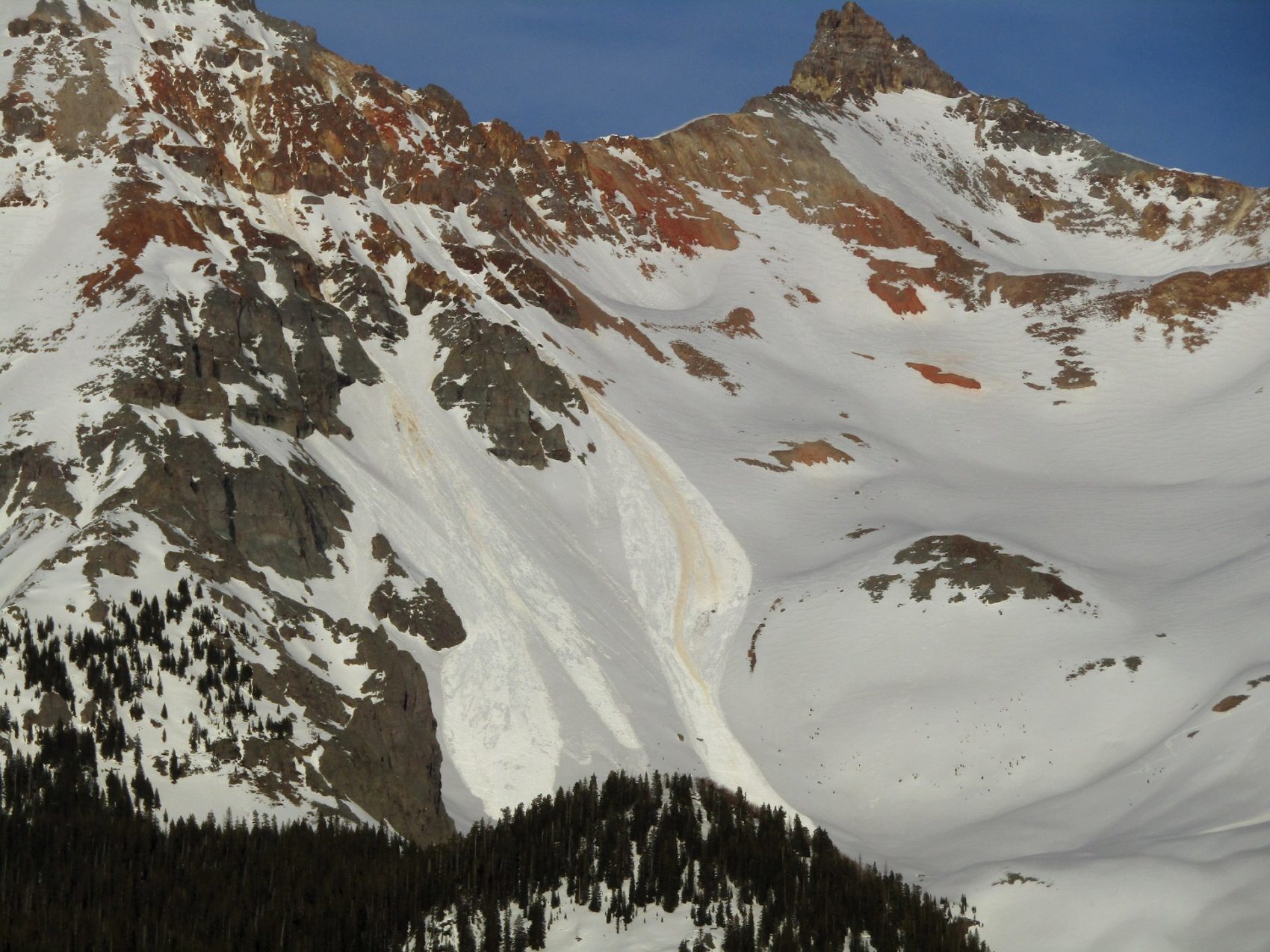
Wet avalanches are making dangerous avalanche conditions. Warm overnight and hot daytime temperatures mean many slopes will be ripe for both Loose Wet and Wet Slab avalanches. Avalanches that start near the top of the snowpack can gouge deeply into the snowpack and entrain a lot of heavy, wet debris. Slides could quickly become large and destructive. Plan to start and end your day early, and expect any supportable crusts to break down quickly. Choose your terrain to avoid traveling across or below any steep terrain with wet, cohesionless snow. Signs that the conditions are deteriorating include a slushy snow surface, a punchy snowpack that no longer supports your weight, pinwheels and rollerballs, and wet avalanches running from steep rocky terrain.
Weather Discussion
Broken clouds will continue moving overhead through the middle of the night. Overnight low temperatures will probably not drop below freezing, and look to stay in the upper 30s near treeline. Gusty winds will continue through at least midnight, then speeds will ease. Gusty ridgetop winds will pick back up mid-day Friday. Skies will be partly cloudy on Friday, but more blue sky than we saw on Thursday. Temperatures remain warm, though should be a few degrees below Thursday’s peak. Friday night temperatures drop closer to freezing, but it will not be a solid or deep freeze. Weekend temperatures remain warm, but not as hot as we saw on Thursday.
You can check current conditions on the Weather Stations page.
Snowpack and Avalanche Discussion
Weak overnight freezes, hot daytime temperatures, spring sunshine, and high clouds means wet avalanche activity will continue. Avalanches are getting larger and running farther with each day of warmth. Melt water is percolating from the surface deeper into the snowpack. Crusts in the upper snowpack are eroding away.
Wet Slab avalanche can be very unpredictable and behave very differently than winter-time slides. They occur when meltwater percolates to weaker layers, or when meltwater pools along crusts. It can take hours or days for water to move to deeper layers, so Wet Slab avalanches do not follow a predictable daytime cycle like loose avalanches do. Buried weak layers on high-elevation, north facing slopes are starting to see water percolating. Weak layers often become active when they see water for the first time, so extra caution is warranted on these steep colder slopes as they transition. Give yourself a wide safety buffer around steep terrain to handle the uncertainty.
Loose Wet avalanches are possible once the upper snowpack loses cohesion. The snowpack may start the day with a supportable crust capping wet snow, but that can break down quickly with sunshine or warm air temperatures. As the whole snowpack gets soggy and cohesionless, the loose avalanches can gouge deeply, entrain lots of snow, and become dangerously destructive. They are running far. You do not want to get tangled up in these slurries.
Safer travel strategies include getting out very early before slopes get too warm and dangerous, and sticking to lower-angle slopes well clear of steeper terrain above. The window of safer travel may be very narrow, and conditions could deteriorate rapidly. There are clear indications that wet avalanche activity is imminent. The first indicator slopes will be Loose Wet avalanches spitting out of steep, rocky terrain that face east and south. The second indication is snowpack strength. When you start punching through the snowpack, or the snow surface is slushy more than about 6 inches deep, it’s time to exit steeper terrain. Avoid traveling across or below steep, sunlit slopes above terrain traps, cliffs areas, or sustained steep pitches.
—
If you are recreating, please do so responsibly. This includes following social distancing requirements, not taking actions that risk pulling emergency service workers away from the important work they’re doing, or compromising their ability to continue that work. Learn more about the CAIC’s work during the pandemic here.
Governor Polis issued a Statewide Safer-at-Home order on April 27, 2020. – Learn more here
Many of Colorado’s counties have issued public health orders that affect travel and recreation. You can start your search for local information for specific counties here.