Written by Dr. Doug Gillham for The Weather Network
The wild and historic winter-like weather that’s impacted parts of Canada this fall looks to provide us with hints of what the upcoming winter has in store. Millions are set for a ‘classic Canadian’ winter season ahead.
Snow and cold have arrived early across much of Canada this fall, including several rounds of historic winter-like weather from the Rockies to the St. Lawrence Valley. Is this a preview of what is to come?
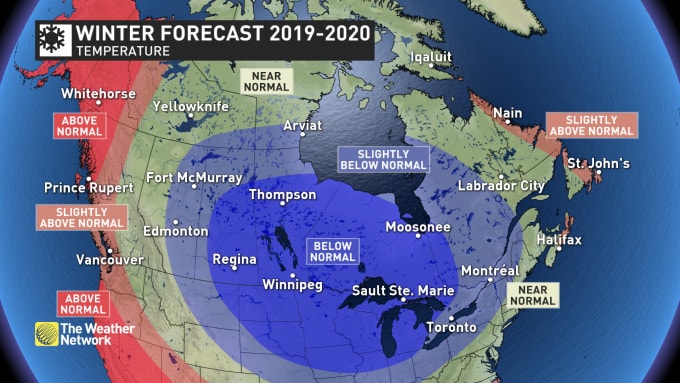
While cold weather hasn’t locked in yet, much of Canada is in for a harsh winter. Near normal or colder-than-normal temperatures are expected for most of the country. The only regions where temperatures are expected to tip to the mild side of normal are near the Atlantic and Pacific coastlines.
The map above shows our temperature forecast for the months of December, January and February. Keep in mind that every region will go through periods that will be a sharp contrast to the dominant pattern for the season.
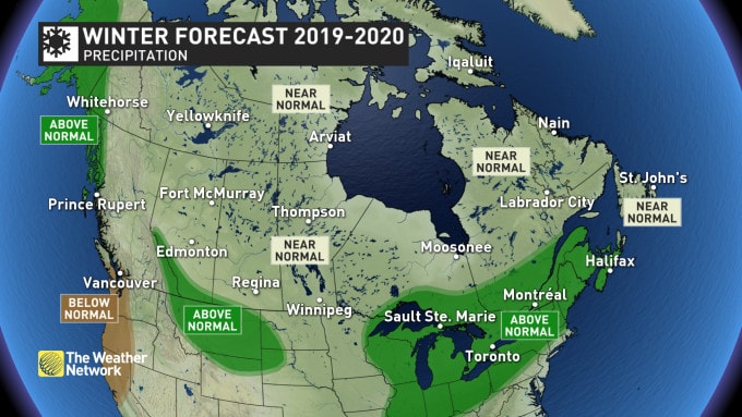
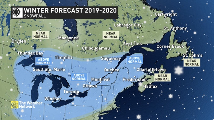
Near normal to above-normal precipitation and snowfall are expected this winter across most of Canada. The most active storm track appears to target the Great Lakes and Atlantic Canada while the driest weather compared to normal is expected to include the south coast of B.C. However, this region, including ski areas, should still receive close to normal snowfall.
BRITISH COLUMBIA
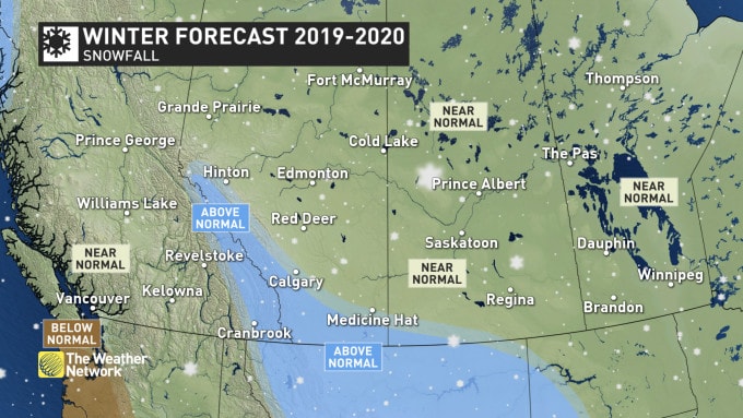
A mild winter is expected along the B.C. coast and across much of northern B.C., while near-normal temperatures are expected from northeastern B.C. to the southern interior. The north coast region is expected to see above-average rainfall and alpine snow. For southern coastal areas, we expect fewer than normal rainy days. However, the dry pattern will break down at times with the potential to see several weeks’ worth of precipitation in just 5 to 10 days. This should help the final precipitation totals approach seasonal.
While a mild and dry forecast is not what skiers want to hear, there are reasons to remain optimistic about the ski season. The periods of active weather should coincide with the periods of cooler weather, allowing ski areas to pick-up substantial snowfall at times. Also, we do not expect the “Pineapple Express” to be a regular feature of the winter, which will help to limit the threat of excessive rain in the alpine regions.
Meanwhile, near normal to above normal snowfall and near-normal temperatures are expected for the central and southern Rockies.
THE PRAIRIES
A long and frigid winter is expected, with the most consistent cold weather across Saskatchewan and Manitoba. Alberta will be more changeable with periods of mild weather at times, which could come close to offsetting the bouts of severe cold.
Near normal snowfall is expected across most of the region, but the foothills of the southern and central Rockies and parts of southern Alberta should end up on the snowy side of normal.
ONTARIO AND QUEBEC
Early November has provided a preview of what is to come, as we expect a long, cold and snowy winter forecast. The cold weather will be most consistent during mid and late winter with extended periods of severe cold — including for major cities such as Toronto, Ottawa, London, and Thunder Bay. An active storm track will likely bring above-normal snow totals to much of the region, along with a risk for freezing rain at times, especially across southern Ontario and into southern Quebec. An abundance of lake-effect snow is likely until above normal ice coverage on the Great Lakes becomes a limiting factor during February.
Looking ahead to spring and beyond, water levels on the Great Lakes could be a major concern. Current water levels on the lakes are well above normal (even near-record levels for this time of year). If we do see a cold and snowy winter across this region, then flooding along the shorelines of the Great Lakes will be a serious issue later in the spring and into the summer.
ATLANTIC CANADA
An inconsistent start to winter is expected, but this region will still see an abundance of winter weather, especially during the middle and end of the season with near to above normal snowfall totals and a heightened risk for ice.
However, southern and eastern coastal areas of Nova Scotia and Newfoundland, including Halifax and St. John’s, will experience periods of milder weather at times with a higher potential for rain. This should keep snowfall totals to near normal across the southern Maritimes despite above-normal precipitation totals.
NORTHERN CANADA
A typical winter is expected across most of the region, including Yellowknife and Iqaluit with near-normal temperatures and snowfall. However, above-normal temperatures are expected to dominate across western areas, including Whitehorse.
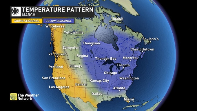
LOOKING AHEAD TO EARLY SPRING
Looking ahead to March, it looks like winter will hold on with a rather sluggish start to the spring season from the central Prairies to Atlantic Canada. Residents of British Columbia are typically the first to see the arrival of spring conditions and this year should bring an especially strong start to the season during March.