
It looks like 2013 for San Francisco, CA is going to be the driest calendar year since records began in 1849. Only 5.59″ of precipitation has fallen shattering the record of 9″ in 1917.
California during 2013 in general had a dry water year (Oct. 1 – Sept. 30) but not the driest water year on record by a long shot. 15 other water years were lower than 2013.


According to the chart above, the Sierra Nevada in January is predicted to receive a 200% increase from last January. Squaw only received 16″ last January, that would amount to a meager 32″. The chart shows 4′-5′ for the Sierra, which may be on the extreme high side the way things are looking in the current models.

The Arctic Oscillation AO is a measure of sea pressure variations north of 20 degrees latitude with the opposite anomalies centered between 37-45 degrees north. We sit at 39N. When the AO is positive surface pressure is low in the polar region. This drives a zonal jet stream from west to east which keeps the arctic air trapped in the higher latitudes. When the AO is in its negative phase it tends to drive the jet stream and subsequent troughs south and allows arctic air to filter into the mid latitudes.

The AO has been in its positive phase most of the season so far.
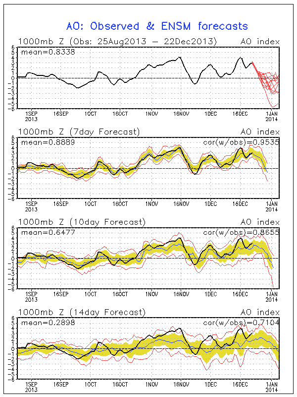
It appears it is getting ready to spike negative. Unfortunately there is no direct linear correlation to the AO and California, however when the AO spikes negative it tends to allow the jet stream to come underneath (undercutting), which at times can create an atmospheric river event (AR) for California.

Here is an animated composite of an AR event. http://climate.nasa.gov/news/997. An AR event is a long narrow deep plume pumping moisture from the tropics into the mid latitudes, sometimes referred to as the “Pineapple Express”. They can cause devastating floods and extreme amounts of high elevation snow for California. It would be nice to see this set up at some point this year! As I tried to illustrate in my previous post, the models have been performing horribly this season. At points it was hinting at the EPO pinching off to the north with the possibility of some early to mid month storms. If that sounds like forever, it looks even uglier now. The CFS doesn’t show a storm until JANUARY 26th!!! We can only hope the models aren’t finally getting their act together…
remember, 200% of last winter is, well, not that much. if i remember correctly, we got 1 foot of snow in tahoe last january?
What gives here?
The most recent 3 reports had us getting little or no snow in January.
(see Is Tahoe Broken) Now we get 200% more than last year.
Sure hope this happens!
Maybe you’re forgetting that we only got a few inches last January?