 Weather


[El Niño 2026-27 ski forecast UPDATED: September 17, 2026]
Note: This is a long-range seasonal outlook based on NOAA climate models, not a short-range snow forecast.
NOAA’s September update places the 2026-27 El Niño outlook alongside the three most powerful warm events since 1950 and introduces the first significant complicating factor of this forecast cycle.
NOAA’s Climate Prediction Center confirmed September 17 that the Niño 3.4 index has risen to plus 2.0 degrees Celsius, up from plus 1.8 degrees Celsius in August. The probability of a historically unprecedented event, one that would exceed every El Niño since 1950, has climbed from 69% to 75%. The odds of at least a very strong event remain greater than 90%.
For the first time in this forecast cycle, forecasters are explicitly consulting the “Big Three” El Niños (the warm events of 1982-83, 1997-98, and 2015-16) as historical analogs. Each of those events reshaped precipitation patterns across the western United States. But this month’s update comes with a complication that was not part of the August discussion.
The Pacific Decadal Oscillation, a longer-term pattern of North Pacific sea surface temperature variability, is currently in a negative phase. All three of the “Big Three” El Niños occurred during a positive PDO, which created constructive interference and amplified their impacts. This time, the negative PDO may dampen typical El Niño influences in certain areas, particularly along the West Coast. In addition, the region of warmer-than-normal sea surface temperatures that typically sits in the Gulf of Alaska during strong El Niños has shifted westward, which may allow slightly cooler water to affect portions of the U.S. West Coast. Forecasters have accounted for both factors in this month’s outlooks.
TL;DR
- El Niño continues to strengthen; Niño 3.4 now at plus 2.0 degrees Celsius.
- Historic event probability rises from 69% to 75%; very strong event odds remain greater than 90%.
- NOAA consults the “Big Three” analogs (1982-83, 1997-98, 2015-16) for the first time — but flags a negative PDO as a moderating factor.
- The PNW coastal temperature signal has eased slightly; the dry zone continues retreating inland.
- California’s wet signal holds; NOAA signals a potential further upgrade in October.
- Colorado and the Four Corners region get an early-season precipitation upgrade.
- The north-dry, south-wet split remains the dominant pattern through core winter.
What’s Changed Since Last Month
Last month’s update raised the odds of a very strong El Niño to greater than 90%. That figure is unchanged in September. What has moved is the probability of a historically unprecedented event — one that would exceed every El Niño since 1950 — which has climbed from 69% in August to 75% in September
The underlying ocean data supports that move. Subsurface temperature anomalies remain significant, reaching plus 10.0 degrees Celsius at depth. The coupled ocean-atmosphere system continues to reflect a strengthening El Niño, with suppressed convection over Indonesia and enhanced convection and rainfall from the central to eastern Pacific.
- Related: El Niño 2026-27 Is Accelerating. NOAA’s July Ski Forecast Has New Winners and Clearer Losers
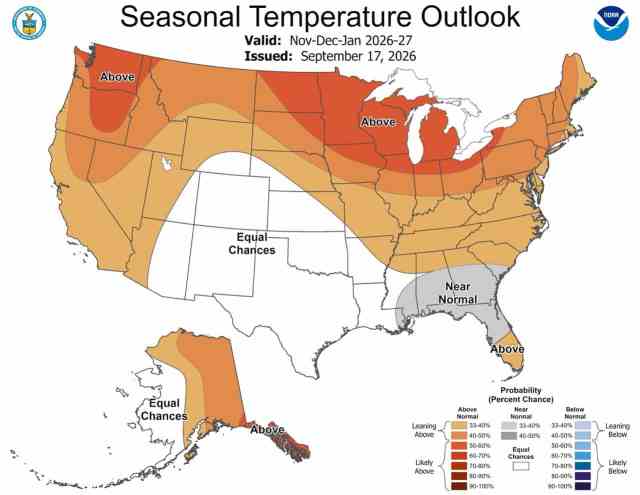
The more significant development in September is not the raw numbers, it is the PDO caveat. NOAA’s forecasters have explicitly flagged that the negative PDO may dampen El Niño’s typical West Coast impacts compared to the historical analogs. That factor directly influenced the OND temperature outlook for the Pacific Northwest, where probabilities favoring above-normal warmth were moderated compared to August. It also contributes to a further retreat of the dry precipitation signal away from the coast and toward the interior.
On the positive side, Colorado and the Four Corners region receive a meaningful early-season precipitation upgrade in this update. The OND precipitation map now shows above-normal precipitation extending from the Four Corners eastward across the southern Plains and along the East Coast. That signal was not as well-established in August’s maps. NOAA also notes that California’s wet signal may be increased further in the next set of outlooks, due in mid-to-late October.
- Related: The Top 9 Snowiest Cities in the USA
The Big Picture
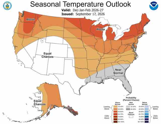
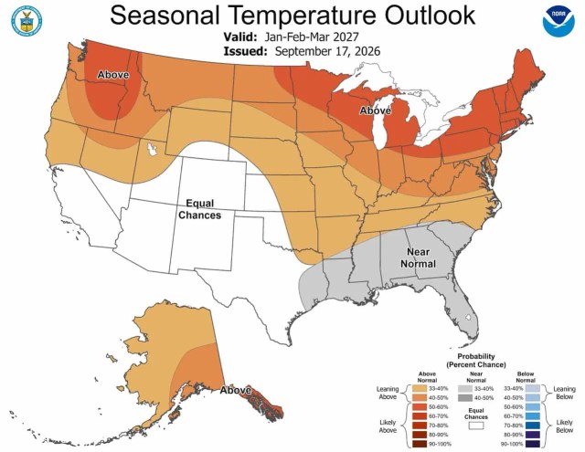
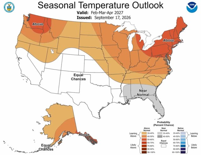
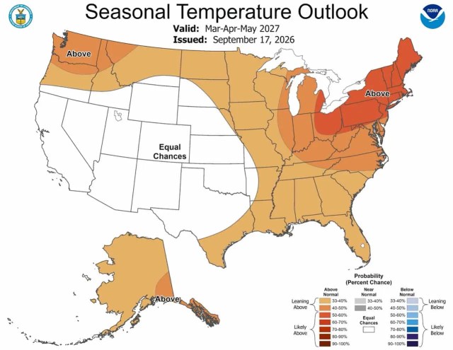
The north-south split that has defined every map in this forecast cycle remains intact. Above-normal temperatures are favored across the northern tier from the Pacific Northwest through the Northern Rockies, the Great Lakes, and northern New England. Near-normal temperatures now appear from the Gulf Coast through the Southeast through the core winter months. Nearly everywhere in the central CONUS sits in equal-chances territory on precipitation.
The main storylines for ski country are unchanged in direction, but refined in detail. California is the favored wet region. The interior Northern Rockies remain the driest zone. Colorado and the Southwest look increasingly favorable for the early season. The negative PDO introduces a degree of uncertainty on the West Coast that was not present in prior months, but NOAA’s forecasters have baked it into the outlooks rather than treated it as a reason to withhold a signal.

El Niño 2026-27 Ski Forecast for Washington, Oregon, Montana, and Idaho
The September update brings the first meaningful improvement for the Pacific Northwest in this forecast cycle.
Forecasters moderated the above-normal temperature probabilities for the PNW coastal region in response to the negative PDO. The August maps showed 60% to 70%-plus probability of above-normal warmth along the coast. The September maps pull that signal back slightly, introducing more uncertainty in the coastal areas. That does not mean a cold winter for Washington and Oregon — above-normal temperatures are still favored — but the signal is no longer as extreme as it appeared a month ago.
On precipitation, the retreat of the dry signal from the coast continues. The below-normal precipitation zone is now concentrated in the interior, covering eastern Washington, northern Idaho, and most of Montana, rather than sitting broadly over the coastline. NOAA notes that the closest analogs to the current El Niño were “wet well north along the West Coast, even encroaching much of the southern half of the Pacific Northwest.” As a result, forecasters have left the typical El Niño dry signal off the coast entirely, restricting it to inland areas. For resorts at elevation in the Cascades, this is the most favorable precipitation signal they have seen in this forecast cycle. Temperatures, however, remain the primary obstacle.
The interior is a different picture. Montana and Idaho continue to sit inside the driest zone on the map through November-December-January and December-January-February. Big Sky, Whitefish, and Sun Valley face suppressed precipitation through the core winter months alongside above-normal temperatures. That combination is unchanged from previous months.
Wyoming sits on the southern fringe of the dry zone. The Tetons occupy a transition area between the below-normal precipitation signal to the north and equal chances farther south. The outlook for Jackson Hole is more favorable than for Montana and Idaho, though it does not represent a strong positive signal.
California, Utah, Colorado and the Southwest: Early Season Improves
California remains the dominant positive story in the El Niño 2026-27 ski forecast.
The DJF and JFM precipitation maps continue to show above-normal probabilities of 50% to 60% for coastal California. NOAA explicitly states those probabilities may be increased further in the October outlooks. Forecasters also note that the favored area of above-normal precipitation “is expected to reach as far north as central Oregon, and possibly farther north given the intensity of this current El Niño event.” For Mammoth Mountain, the Lake Tahoe ski areas, and the broader Sierra Nevada, this is an increasingly strong and increasingly well-supported seasonal signal.
Colorado and the Four Corners region receive the biggest upgrade in September’s maps relative to August. The OND precipitation outlook now shows above-normal probabilities extending from the Four Corners eastward across the southern Plains. That represents a meaningful early-season improvement for Colorado ski areas. Maximum probabilities for above-normal precipitation reach 60% to 70% over parts of the Southeast in OND, with the signal extending northward along the eastern Plains. For Colorado, the direction is clearly positive for opening season.
The core winter picture for Colorado and Utah remains in equal-chances territory through DJF. There is no favored dry signal and no strong wet signal for the central Rockies during the heart of winter. Equal chances means the outcome is open — the models carry no directional lean. High-elevation terrain is best positioned if storms deliver.
New Mexico and Arizona continue to benefit. Near-normal temperature signals and above-normal precipitation probabilities remain in place across the Southwest through the core winter months. Taos, Ski Santa Fe, and Arizona Snowbowl have now carried consistently positive signals across five consecutive monthly updates.
El Niño 2026-27 Ski Forecast for the East: Warm, Variable, Elevation-Dependent
The Northeast precipitation picture remains in equal-chances territory. No suppressed storm track is forecast for New England. No enhanced one is either.
Temperatures continue to favor above-normal conditions throughout the winter, with 50% to 60%-plus probability for New England and the Mid-Atlantic through the core winter months. That signal is consistent with August and has not moderated.
The Great Lakes continue to carry below-normal precipitation leans through DJF and JFM, which reduces lake-effect snowfall potential for western New York ski areas. Vermont and New Hampshire’s higher terrain, above 4,000 feet, is best positioned to hold snow between events. Snowmaking remains the critical variable for eastern ski areas this season.
How Much Should You Trust the El Niño 2026-27 Ski Forecast This Early?
The September update adds both confidence and nuance in equal measure.
The confidence comes from the continued strengthening of El Niño itself. The Niño 3.4 index has now risen every month since May. At plus 2.0 degrees Celsius and climbing, the event is tracking toward or past the historic threshold. NOAA’s models are in strong agreement on both the existence and the continued intensification of this event through the core ski season.
The nuance comes from the negative PDO. All three of the “Big Three” historical El Niños, the closest analogs to the current event, occurred when the PDO was positive. This one is not. Forecasters cannot say precisely how much the PDO will dampen El Niño’s typical impacts, only that it is a factor they have incorporated into the outlooks. On the West Coast in particular, that means somewhat less certainty about the magnitude of the warm and wet signals than the raw El Niño numbers would otherwise suggest.
What the September forecast tells you is that the directional signals are well-established and strengthening, but the PDO introduces a layer of complexity that was not present in the August analysis. For California, the favored outcome is still a wet late winter. For the interior Northern Rockies, a dry winter remains the favored outcome. For the PNW coast, the picture is slightly better than it looked in August, and may improve further in October. For Colorado and the Southwest, the early season has gotten meaningfully more encouraging.
The October outlooks will be available in mid-to-late October. At that point, El Niño will be approaching its peak strength, and the forecast confidence will reach its seasonal high.
Frequently Asked Questions: El Niño and the 2026-27 Ski Season
Does El Niño mean more snow?
Not everywhere. El Niño brings above-normal precipitation to the southern tier — the Southwest, southern Rockies, and Southeast — while suppressing precipitation across the Pacific Northwest and Northern Rockies. Whether it means more snow at a specific mountain depends entirely on location.
Is El Niño good for skiing?
It depends on the region. El Niño winters benefit ski areas in Colorado, New Mexico, and the southern Rockies, which sit under a wetter southern storm track. They generally hurt the Pacific Northwest and Northern Rockies, which run warmer and drier. For the Northeast, El Niño brings above-normal temperatures and a variable precipitation signal — manageable at elevation, difficult at lower-elevation ski areas.
Is El Niño good for California skiing?
California remains the biggest winner in the El Niño 2026-27 ski forecast. NOAA puts greater than 50% probability of above-normal precipitation for coastal California in DJF and JFM, with forecasters signalling a potential further upgrade in October. The wet signal may reach as far north as central Oregon. For Mammoth, the Tahoe ski areas, and the broader Sierra Nevada, this is an increasingly well-supported seasonal signal.
What does El Niño mean for Utah skiing?
Utah sits in equal-chances territory on precipitation through the core winter months. No favored dry outcome exists — storms can still deliver. Above-normal temperatures remain the primary risk, raising snow levels and reducing quality at lower elevations. High-elevation Wasatch resorts are best positioned.
What does El Niño mean for Colorado skiing?
Colorado receives a meaningful early-season upgrade in September’s maps. Above-normal precipitation now extends into the Four Corners and southern Rockies during October-November-December. Core winter precipitation through NDJ and DJF remains in equal-chances territory; no favored dry signal, no favored wet signal. Above-normal temperatures apply pressure on terrain below 9,000 feet. High-elevation resorts are best positioned if storms deliver.
What does El Niño mean for the Pacific Northwest?
The Pacific Northwest carries the strongest above-normal temperature signal on the map — 60% to 70%-plus probability of warmth from October through February. Combined with below-normal precipitation in coastal areas transitioning to confirmed dry conditions in the Northern Rockies interior, the region faces the most difficult outlook in ski country. Bachelor and the lower Cascade ski areas are most exposed.
What does El Niño mean for Montana and Idaho skiing?
Montana and Idaho now carry the driest signal on the map through the core winter months, combined with above-normal temperatures. Big Sky, Whitefish, and Sun Valley face a slow start to the season and suppressed snowpack development. Wyoming sees a modest relative improvement — the dry zone’s southern edge runs through the northern part of the state — but the Tetons remain inside the warm temperature signal.
Is El Niño good or bad for ski areas overall?
It is a north-south story. Southern and central mountain ski areas — Colorado, Utah, New Mexico, Arizona, and especially California — have a reasonable to strong outlook. Northern ski areas — the Pacific Northwest, Montana, and Idaho — face a difficult season. The Northeast is warm but not suppressed in precipitation. No region is a certain winner, and no region is a complete write-off. Elevation is the deciding factor in every case.
What is a super El Niño?
“Super El Niño” is an informal term used by media and some forecasters to describe a very strong El Niño event — one where Niño 3.4 sea surface temperature anomalies exceed +2.0 degrees Celsius. NOAA does not use the term officially, but the 2026-27 event is currently projected to reach that threshold, with NOAA now placing a 75% probability on an event that would surpass all El Niños on record since 1950, and greater than 90% odds of at least a very strong event.
El Niño 2026-27 ski forecast: Full NOAA Discussion
Prognostic Discussion for Long-Lead Seasonal Outlooks NWS Climate Prediction Center College Park MD 830 AM EDT Thu Sep 17 2026 SUMMARY OF THE OUTLOOK FOR NON-TECHNICAL USERS El Niño conditions are present, as represented in current oceanic and atmospheric observations. El Niño is strengthening, with a greater than 90 percent chance of a very strong event this fall and winter. The October-November-December (OND) 2026 Temperature Outlook favors above normal temperatures for much of Alaska as well as most areas west of the Rockies, nearly all areas east of the Mississippi River, and the northcentral states in-between. The highest probabilities (greater than 50 percent) of above normal temperatures are forecast across Southeast Alaska, the Northern Great Basin, and the vicinity of North Dakota and northwestern Minnesota. The OND 2026 Precipitation Outlook depicts enhanced probabilities of above normal precipitation amounts from the southern half of California east-northeastward across most of the Four Corners region and Great Plains, much of the Mississippi and Tennessee Valleys, the Southeast, and the Mid-Atlantic. The greatest chances (higher than 60 percent) for above normal precipitation are indicated for parts of the eastern Gulf Coast region and Southeast coast. A modest tilt in the odds towards above normal precipitation is depicted from portions of southcentral Alaska eastward through much of Southeast Alaska. Modest tilts towards below normal precipitation amounts are favored over the Aleutians, interior portions of Mainland Alaska, interior portions of the northwestern CONUS, and parts of the Great Lakes region. Equal chances (EC) are forecast for areas where probabilities for each category of seasonal mean temperatures and seasonal accumulated precipitation amounts are expected to be similar to climatological probabilities. BASIS AND SUMMARY OF THE CURRENT LONG-LEAD OUTLOOKS Note: For Graphical Displays of the Forecast Tools Discussed Below See: http://www.cpc.ncep.noaa.gov/products/predictions/90day/tools/briefing CURRENT ATMOSPHERIC AND OCEANIC CONDITIONS El Niño strengthened over the past month, with sea surface temperature (SST) anomalies exceeding +3.0°C in the eastern equatorial Pacific. The latest weekly Niño index value for Niño-3.4 was +2.0°C, and for Niño-3 the index value was +2.8°C. The equatorial subsurface temperature index (average from 180°-100°W) remained steady during August, reflecting a deeper-than-average thermocline. Subsurface temperature anomalies were significant, reaching +10.0°C at depth. Low-level westerly wind anomalies and upper-level easterly wind anomalies extended from the western to east-central equatorial Pacific. Convection and rainfall were enhanced from the central to eastern Pacific and were suppressed over Indonesia. The traditional and equatorial Southern Oscillation indices were significantly negative. Collectively, the coupled ocean-atmosphere system reflected a strengthening El Niño. PROGNOSTIC DISCUSSION OF SST FORECASTS The CPC Official El Niño Southern Oscillation (ENSO) Outlook, which synthesizes multiple models from North America and abroad, indicates El Niño will continue to strengthen through the end of the year. During the October-November-December (OND) 2026 season, there is a 75% chance of a historic event that would exceed the strength of previous El Niño events dating back to 1950 (+2.5°C or more for a 3-month RONI value). With an event of this magnitude, the chances of experiencing impacts consistent with El Niño are larger, but they are not guaranteed. In summary, El Niño is strengthening, with a greater than 90% chance of a very strong event during the Northern Hemisphere fall and winter 2026-27. PROGNOSTIC TOOLS USED FOR U.S. TEMPERATURE AND PRECIPITATION OUTLOOKS Newer RONI ENSO composites derived from the current and forecast state of ENSO were strongly utilized due to the magnitude of this El Niño event. Analogs of the "Big Three" El Niño's were also considered in making the temperature outlooks throughout the fall and winter. Dynamical model forecasts from the North American Multi-Model Ensemble (NMME), the Climate Forecast System version 2 (CFSv2), and the Copernicus (C3S) multi-model ensemble system were also used for the first six leads when they are available, as was the objective, historical skill-weighted consolidation and Calibration, Bridging, and Merging (CBaM) guidance, that combines both dynamical and statistical forecast information. Analysis of antecedent conditions such as extratropical SST anomalies and sea ice extent were considered where appropriate. At later leads, decadal trends in temperature and precipitation were increasingly relied upon in creating the seasonal outlooks. PROGNOSTIC DISCUSSION OF OUTLOOKS - OND 2026 TO OND 2027 TEMPERATURE The seasonal temperature outlooks for this fall and winter rely heavily on the high likelihood of a very strong El Niño. In most cas es, the presence of a very strong El Niño would overwhelm contributions from climatic modes of mid to high-latitude variability, such as the Arctic Oscillation (AO) or North Atlantic Oscillation (NAO). There are two factors that make the current situation unique. The first factor is the presence of a fairly strong, negatively phased Pacific Decadal Oscillation (PDO), with the August PDO index value of -1.11 . The "Big Three" historical El Niño's since 1950 include the warm events of 1982-83, 1997-98, and 2015-16, all of which occurred when the PDO phase was positive, leading to constructive interference. This time, however, the PDO phase is negative and may dampen the typical impacts of a strong El Niño in certain areas. The second factor involves the large region of warmer-than-normal SSTs that is typically present in the Gulf of Alaska during strong El Niños. The current situation shows a significant westward shift in these warmer SSTs, which may allow for slightly cooler water to influence portions of the U.S. West coast. In addition, even with the possibility of one or more cold air outbreaks across the northwestern quarter of the Lower 48 states, it is unlikely that this will have much of an impact on the average temperature for a 90-day season. With the above considerations in mind, the October-November-December (OND) 2026 temperature outlook favors above normal mean temperatures over most of the western, northern, and eastern Contiguous U.S. (CONUS). This is based on much of the dynamical and statistical temperature guidance, including the hybrid CBaM output. Adjustments rendered to the OND outlook made last month include an expansion of modest probabilities of above normal temperatures across most of the Southeast, which is reasonable given the typical El Niño cool signal doesn't usually show up in this region until December. Over the Northern CONUS, the 40-50 percent probabilities favoring relative warmth were extended eastward across the Great Lakes and Northeast, with October and November warmth also supported by longer-term trends . Over the Pacific Northwest coastal region, probabilities favoring warmer-than-normal temperatures were tempered a bit in response to potential influences from a negative PDO. In Alaska, most of the models and tools support above normal temperatures over much of the central and eastern Mainland, the North Slope, and Southeast Alaska, with the highest probabilities (50-60 percent) favored over Southeast Alaska. A broad area of Equal Chances (EC) of above, near, and below normal temperatures is depicted from the southern Rockies eastward across the southern Plains and into the Lower Mississippi Valley, based on weak and/or conflicting signals . From late fall to early spring (November-December-January (NDJ 2026-27) to February-March-April (FMA 2027), the outlooks showcase a classic El Niño signature featuring increased chances of above normal temperatures over many areas west of the Rockies, and over northern and central portions of the country east of the Rockies. The highest chances (50-60 percent) for above normal temperatures are indicated over interior portions of the Northwest and along much of the northern tier of states. Over the Southwest, the modest tilt towards relative warmth gradually gives way to EC. For much of the Southeast, a region of near normal temperatures is introduced during NDJ and continues through the FMA season. This reflects competing influences between the cooler El Niño signal during winter and milder historical trends . By March-April-May (MAM 2027), the current El Niño is forecast to weaken significantly, possibly becoming ENSO-neutral later in the spring. Anomalous warmth is expected to return to the Southeast by this time, with much of the East favoring above normal temperatures with the highest chances of 50-60 percent depicted from the Lower Great Lakes eastward to the Northeast coast. Relative warmth is also favored to extend westward across the Dakotas, Northern Rockies, and Pacific Northwest. From April-May-June (AMJ 2027) through the remaining leads, the temperature outlooks are based primarily on long-term historical trends and feature widespread above normal temperatures. For Alaska temperatures, widespread above normal temperatures are favored over the central and eastern Mainland, Southeast Alaska, and the North Slope for the first three leads, OND 2026 through DJF 2026-27. This is supported by most of the dynamical and statistical guidance, the hybrid CBaM output, and trends . The greatest probabilities are indicated over Southeast Alaska, and range from 50-60 percent. Relatively warm mean temperatures are favored over the state for the remaining leads, with the exception of EC over western portions of Alaska during MJJ, JJA, and JAS 2027, in part due to the effects of sea ice and cooler SSTs. PRECIPITATION El Niño composites highlight a robust wet signal across the southern and central CONUS in OND, primarily from the Four Corners region eastward across the southern Plains to the Southeast coast. Modest extensions of this wet signal extend westward across the southern half of California, northward over the Great Plains into portions of South Dakota, and northward along the Eastern Seaboard to include the Upper Mid-Atlantic region. Maximum probabilities for above normal precipitation range from 60-70 percent over parts of the Southeast, which is well supported by a large number of models and tools, and is reasonable given the current and predicted strength of El Niño. Two relatively modest signals for below normal precipitation are depicted over the interior northwestern CONUS and the Great Lakes region, consistent with historical El Niño events and many of the objective tools. From NDJ 2026-27 through FMA 2027, the precipitation outlooks are heavily based on ENSO composites, with adjustments rendered according to dynamical and statistical model guidance. The wet signal across the southern and central CONUS, and extending northward along the Atlantic coast into New England, is the dominant precipitation signal this fall and winter, and is associated in large part with the mean position of the subtropical jet stream and the mean storm track. Probabilities favoring wetter-than-normal conditions increase across California, reaching a maximum of 50-60 percent near the coast during DJF, JFM, and FMA. These probabilities may be increased further in the next set of seasonal outlooks, to be released in mid-late October, pending reassessment of the latest model forecasts. The favored area of above normal precipitation is expected to reach as far north as central Oregon, and possibly farther north given the intensity of this current El Niño event. Over the southern Plains, probabilities for above normal precipitation reach a maximum of 40-50 percent, increasing across much of the Gulf and Southeast coasts to a maximum of 70-80 percent over southern Georgia and northern Florida. The two areas of modestly favored below normal precipitation over the interior Northwest and Great Lakes region are expected to persist but remain rather weak through FMA 2027. During March-April-May (MAM) 2027, the El Nino signal is expected to weaken considerably with the dominant and contiguous wet signal over the southern and central CONUS forecast to split into three separate, and less widespread, regions: one over California and the Southwest, another over the Upper Midwest/eastern Dakotas, and the third encompassing much of the Gulf and Atlantic coasts. The token dry signal favored over the Great Lakes during the fall and winter disappears, and the below normal precipitation region over the interior Northwest begins to expand in spatial extent from MAM to JJA 2027, heavily influenced by decadal trends . In addition, the precipitation anomalies typically associated with El Niño are forecast to gradually wane during the spring. For the summer and early fall of 2027, long-term precipitation trends play a large role in the outlooks. In Alaska, newer ENSO composites were used for the fall and winter, followed by dynamical model output; for subsequent seasons decadal precipitation trends formed the basis of the outlooks. In OND 2026, small areas of slightly favored below normal precipitation are depicted over portions of the Central Interior and the Aleutians, while above normal precipitation is slightly favored from the southeastern Alaska Mainland to the northern Panhandle region. In NDJ, the two dry signals consolidate into one larger one that extends from the southwestern Mainland to the Central Interior, and above normal precipitation continues over Southeast Alaska, the latter being a common occurrence during warm events. By DJF, composites show a widespread dry signal over most of the Mainland, which continues through FMA but weakens significantly by MAM 2027. The Southeast Alaska wet signal remains throughout these seasons, though waxes and wanes in coverage. The precipitation outlooks from AMJ 2027 onward are based on longer-term precipitation trends , with the primary and most durable signal being above normal precipitation favored over much of the southern coast of Alaska. FORECASTER: Anthony Artusa





Content looks AI generated. Please don’t do that.
100% agree. Gross
A quick note from a Portlander who has lived and skied Mt. Hood & Mt. Bachelor for 50+ years. Thank-You for the reliable & scientifically supported NOAA forecast for Winter 26-2027. So appreciated. From 2025-2026 ski/riding season we do empathize with mountain resorts and towns dependent on the winter business. I will not purchase a ski pass for 2026-27 season and ski as the snow & my schedule permits. Very loyal to Mt. Hood however last years one ski day for my season past cost of $700 was steep. Thanks NOAA & SnowBrains for the forecast, it is appreciated! We will pray for snow to help the agriculture, farmers & just general water needs of the PNW & hope for a controlled fire season-2026.