Forecast created by SnowBrains forecaster Clay Malott at 5pm PST
California is about to see a historically huge storm cycle, which will drop rain, snow, and everything in between on the Sierra Nevada mountains between Monday and the first week of January. The first storm will be from tonight through Wednesday morning (12/28) and the second system will begin on Thursday morning (12/29) and last through the morning of January 1st. This forecast will focus on the first wave, stay tuned for a forecast for the second save in the next few days.
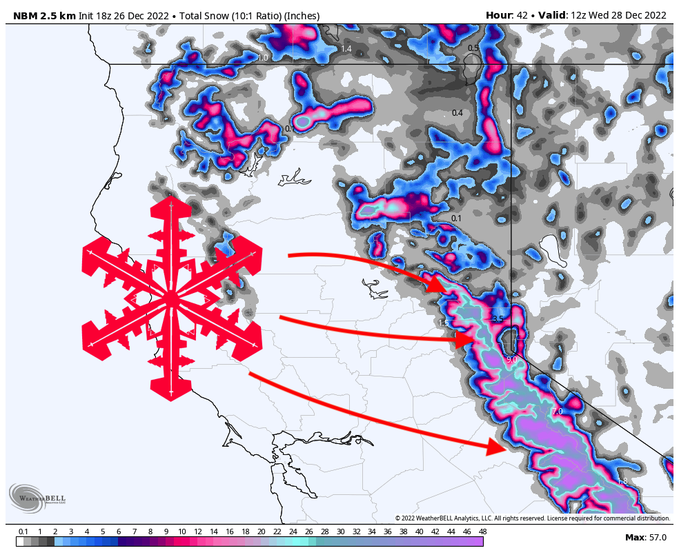
As of the writing of this forecast, rain is just beginning to creep into coastal California. The first precipitation will hit the mountains in Tahoe at around 9 pm and continue throughout the night. Temperatures will be bordering on rain and snow overnight for much of the region, especially on the West Shore. Small errors in the current temperature forecasts could mean the difference between all rain and 12″ of fresh snow. By Tuesday morning, most resorts will not see much snow at mid-mountain and below. However, resorts higher up like Mt. Rose and Kirkwood could see significant snow totals, albeit fairly dense, wet snow. 4-8″ at Mt. Rose and 8-12″ at Kirkwood by tomorrow morning make them the best powder chasing targets Tuesday. Keep in mind that the lower elevations of all mountains will be fairly miserable tomorrow with warm temperatures and rain.

By the time lifts start spinning on Tuesday, temperatures will have dropped enough to allow snow at most resort mid-mountains. Snow levels will continue to drop throughout the day, leading to better quality snow at the resorts and may even permit snowfall down to the lake on Tuesday evening. Here are what I see as reasonable totals over the course of the ski day on Tuesday:
- Palisades Tahoe: 8-12″
- Sugar Bowl: 8-12″
- Kirkwood: 8-15″
- Mt. Rose: 8-15″
- Heavenly: 8-12″
Keep in mind that this snow will still be heavy and wet and probably not amazing skiing. But it’s better than rain!
Mammoth will start seeing snow on Monday night, as well. Higher elevations will allow it to pick up as much as 9-13″ by the time lifts start spinning on Tuesday and an additional 12-20″ throughout the day on Tuesday.
Precipitation will diminish overnight on Tuesday and will be basically done by Wednesday morning. Most resorts will only pick up a few more inches.

The next wave of precipitation begins on Thursday morning. The specifics remain pretty uncertain, so I don’t want to forecast exact totals quite yet. However, the next wave of moisture from Thursday-Sunday is looking colder and more promising for good skiing quality. Potential totals at resorts are looking to be anywhere from 2-4 FEET! There is still quite a bit of uncertainty with this system, but it’s looking promising… stay tuned for a forecast for the second wave in the coming days.