A backcountry skier was killed in an avalanche on Saturday, March 19 in the Buffalo Pass area northeast of Steamboat Springs, CO.
Two skiers were involved in the avalanche at approximately 12:20 pm, according to the CAIC. The accident occurred in the North Fork of Fish Creek drainage, northeast of Steamboat Springs. The two men had snowmobiled into the area before skiing through the backcountry. Skier 1 was caught in the avalanche and came to rest against a tree. He was not breathing when his companion reached him. Skier 2 performed CPR for close to an hour as the Routt County Sheriff’s Office, Routt County Search and Rescue, and Classic Air responded to the scene. CPR was not successful. Classic Air evacuated Skier 2 via helicopter.
“He was doing CPR while he was on the phone with dispatch.”
– Undersheriff Doug Scherar told KCNC-TV
The man was still performing CPR an hour later when crews reached him. The skier who died has been identified as Andrew Hyde, 49, of Steamboat Springs. The full CAIC describing the accident in detail has been released and is attached below.
There have been 15 avalanche-related fatalities in the US this winter.
CAIC REPORT
Avalanche Comments
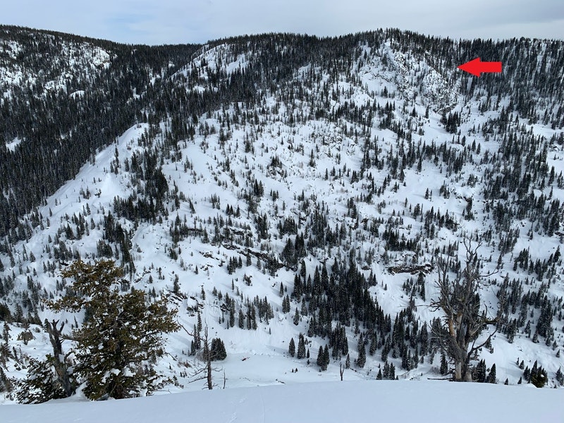
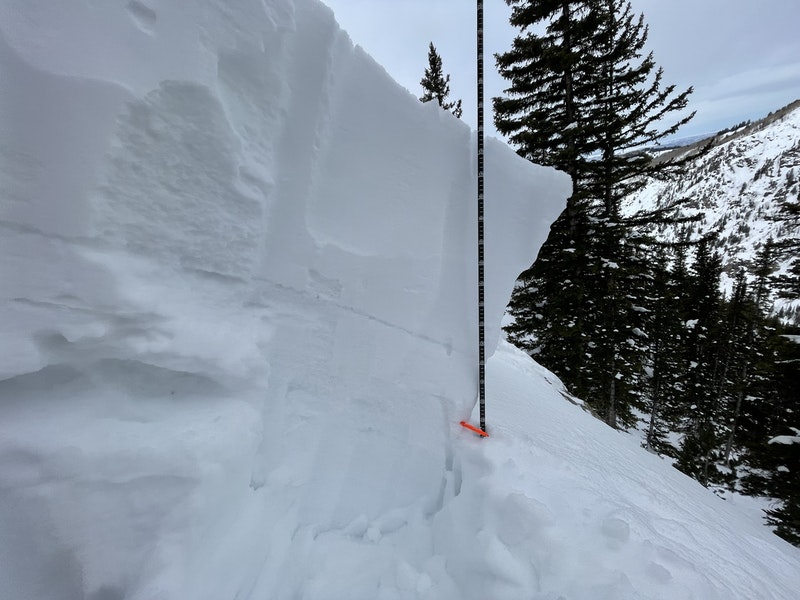
This was a soft slab avalanche, unintentionally triggered by a backcountry skier, that broke on a persistent weak layer buried 18 to 28 inches deep. It was small in size relative to the path and produced enough destructive force to bury, injure, or kill a person (SS-ASu-R2-D2-O). The avalanche was 100 feet wide, ran 450 vertical feet, and released on a 40 degree, northwest-facing slope.
Backcountry Avalanche Forecast
The Colorado Avalanche Information Center’s (CAIC) forecast for the Steamboat and Flat Tops zone on the day of the avalanche rated the avalanche danger as MODERATE (Level 2) in all three elevation bands. The forecast listed Persistent Slab avalanches as the only problem on northwest, north, northeast, and east-facing slopes in the above, near, and below treeline elevation bands. The likelihood of triggering was Possible, and the potential size was Small to Large (up to D2). The summary statement read:
You can trigger dangerous avalanches on northerly and east-facing slopes at all elevations. In these areas, a weak layer is buried two to three feet deep. It is unlikely you will get warning signs like cracking or collapsing. Traveling on these steep slopes will require you to evaluate the snowpack carefully. Look to see if a buried weak and softer layer exists under a thick and harder slab of snow. If this sounds complicated, simply stick to slopes less than about 35 degrees. Safer conditions exist on southerly slopes, but you will still have to pay attention to the bond of new snow and underlying crusts. If the snow seems to slide easily on the crust, especially as the day warms, stick to low-angle slopes on these aspects too.
On Thursday, a backcountry skier was killed in an avalanche in the North San Juan zone. The avalanche was on a northwest-facing, above-treeline slope. Our deepest condolences go out to the friends and family and everyone involved in this accident. You can find a preliminary report here.
Weather Summary
A large storm impacted the Park Range from January 4 to January 6, 2022. The Steamboat ski resort, located 4 miles southwest of the accident site, reported 29 inches of snow over these three days. Another small storm followed on January 8. An unusually dry stretch of weather set in for the next five weeks. The Steamboat ski resort reported 15 inches of snow from January 10 to February 15. Temperatures during this period were generally cold, near to below freezing at the Tower SNOTEL site, located 3 miles northeast of the accident site at an elevation of 10,607 feet. There were long stretches of clear skies. Beginning on February 16, the weather pattern changed, and several storms affected the area up until the day of the accident. The largest storm during this period impacted the area on March 8 to 9 when the Steamboat ski resort picked up 21 inches of snow.
On the day of the accident, skies were mostly clear, winds were light, and the Tower SNOTEL site recorded a maximum temperature of 34 degrees Fahrenheit at 2 PM.
Snowpack Summary
A weak layer of near-surface faceted crystals formed in the upper snowpack during the very dry period between January 10 and February 15. Observers reported loose avalanches in this cohesionless snow while it was at the snow surface. A storm on February 15 buried this weak layer, and subsequent snowfall built a thick slab of snow on top. Between February 15, when the weak layer was buried, and March 19, the day of the accident, the Steamboat ski resort recorded nearly 69 inches of snowfall. This new snow settled into a strong slab of snow between two and three feet thick.
After February 15, the CAIC recorded 13 human-triggered avalanches in the Steamboat and Flat Tops zone. Seven of these occurred in the ten days preceding the accident. Most of these avalanches were small, but they all broke on the buried layer of near-surface faceted crystals. This is an unusually high number of avalanches in the Steamboat and Flat Tops zone over a relatively short time period. It is nearly 40% of the avalanches recorded in the zone between October 1, 2021, and March 18, 2022. On March 12, a snowmobiler was killed when he triggered an avalanche on this same weak layer in the Sierra Madre Range in Wyoming, approximately 40 miles north of this accident site
Events Leading to the Avalanche
On March 19, two backcountry skiers planned a trip to an area locally known as the Dome in the North Fork of Fish Creek. The area is approximately eight miles east of the town of Steamboat Springs. Skier 1 arrived at the Dry Lake trailhead around 8:30 AM. He was early. He read the CAIC avalanche forecast and took note that it listed a Persistent Slab avalanche problem in all elevation bands on northwest, north, northeast, and east-facing aspects. He made a quick ski run on a low-angle, west-facing slope near the parking lot. He felt the snow was stable in this area.
Skier 2 arrived at the Dry Lake trailhead around 10:30 AM, and the two skiers proceeded to unload their snowmobiles. They rode east up County Road 38 for about 11 miles to Buffalo Pass, where they turned south towards Fish Creek Reservoir. They then rode north toward the Dome and parked their snowmobiles. Skier 2 had skied in the area many times and took the lead. The pair skinned across three small knobs until they got to the spot where Skier 2 planned to descend into the North Fork of Fish Creek. They took off their climbing skins and began their descent.
Skier 2 descended 100 to 200 vertical feet on a treed slope. He waited for Skier 1. They did not see any cracking in the snow or hear any whumpfing. The two traversed eastward until they were above a steeper, sparsely treed part of the slope. On the traverse, Skier 1 pushed with his downhill ski to see if he “could get snow to move.” He saw no indications of unstable snow.
Accident Summary
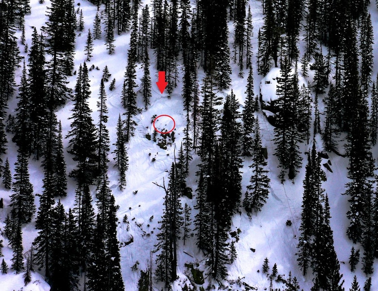
Skier 2 rode down into the steeper, more open area while Skier 1 waited. Skier 2 made one turn, and the whole slope dropped, making a large whumpf. Skier 1 saw cracks shoot out around Skier 2 as the avalanche broke two to three feet above him. Skier 2 yelled “avalanche” and the moving snow knocked him off his feet and swept him down the hill and out of sight.
Rescue Summary
Skier 1 turned his transceiver to receive before the avalanche came to a stop. He could see rocks in the spot where Skier 2 triggered the slide. He picked his way through the rocks and over a rollover in the slope. From there, he could see Skier 2 pinned against a tree with his back facing uphill. Snow had piled up behind him and he was not moving. Skier 1 descended just below Skier 2, took off his skis, and climbed back to Skier 2.
Skier 1 cleared snow out of Skier 2’s mouth and gave him two rescue breaths. He gave two more, but Skier 2 did not respond. Skier 1 called 911 to report the avalanche and ask for help. It was 12:20 PM. The 911 dispatcher instructed Skier 1 to start CPR. Skier 1 cleared the avalanche debris from Skier 2’s back to create a flat spot and began CPR. He continued CPR for about an hour.
The Routt County Sheriff’s Office activated Routt County Search and Rescue (RCSAR) at 12:28 PM and enlisted Classic Air Medical. SAR personnel and the helicopter crew verified the location of the avalanche shortly after 1:15 PM. RCSAR members reached the Dome around 2:30 PM and made radio contact with Skier 1. Skier 1 tried to hike back upslope to the RCSAR members on the ridgeline. He was unable to climb through the deep snow above the avalanche crown and decided it would be safer to ski downhill to the creek. The Classic Air Medical crew landed the helicopter around 4:30 PM and flew Skier 1 out. RCSAR personnel decided it was too dangerous to begin the operation to retrieve Skier 2 that night.
On March 20, Classic Air Medical flew two CAIC forecasters and two RCSAR members to the accident site. The team assessed the avalanche hazard and found a safe route to the accident site. More RCSAR team members arrived on snowmobiles. RCSAR teams set up two raising systems and hauled Skier 2 over 400 vertical feet to the top of the slope. They brought Skier 2 back to the Dry Lake trailhead via snowmobile.
Comments
All of the fatal avalanche accidents we investigate are tragic events. We do our best to describe each one to help the people involved, and the community as a whole better understand them. We offer these comments in the hope that they will help people avoid future avalanche accidents.
The avalanche broke on a layer of near-surface faceted crystals buried in the middle of the snowpack. Snow layers this weak are not common in the Park Range of Colorado. It is especially unusual to see a layer this weak, this deep in the snowpack, and still reactive in mid-March. The danger posed by avalanches breaking on this weak layer was well documented in the avalanche forecasts and reports of avalanche activity in the Steamboat and Flat Tops zone. A description of this layer and its role in a fatal avalanche accident, just 40 miles north in Wyoming, on March 12 was included in the report on that accident. In this accident, Skier 2 had many years of experience in the Park Range. He also skied in and around the Fish Creek drainage with some regularity. We will never know what Skier 2’s decision making process was on the day of the accident. However, we do know that people’s tendency to rely on familiar places and familiar situations to help them make decisions is well documented (Herbert, 2010). When we are accustomed to behaving in a certain way in a certain area, it can be very difficult to recognize unusual conditions and change our approach to familiar terrain.
Modern avalanche safety courses teach a repeatable trip planning process. The process includes using the avalanche forecast to determine the type of terrain you want to avoid, then reviewing your route to ensure it keeps you away from the dangerous areas. On the day of the accident, the two skiers did not discuss the avalanche forecast or the details of their plan before departing the trailhead. Skier 1 read the forecast and knew it warned of Persistent Slab avalanches on northerly-facing slopes. Skier 2 was very familiar with the terrain, but we do not know if he read the avalanche forecast. Although Skier 1 knew the general destination, he did not know the terrain well enough to match it with the information in the avalanche forecast and decide in advance if their route was appropriate for the avalanche conditions on that day.
CAIC investigators found a deep and strong snowpack on the slope above the avalanche. As they descended, the slope angle increased, and the terrain became more complex, with rocky areas and small cliffs. Here the snowpack was thinner, and the weak layer was more pronounced. Backcountry tourers often trigger avalanches on persistent weak layers, like this one, from an area where the snowpack is shallow (see this video from renowned avalanche scientist Bruce Jamieson). It is challenging to evaluate snowpack depth and its relation to weak layer distribution. While it is sometimes possible to identify and avoid potential trigger points, the consequences of being wrong are severe. Persistent Slab avalanches are difficult to predict and are especially dangerous when they do not provide the feedback we expect, like cracking and collapsing in the snow. The best strategy during these periods is to use the avalanche forecast to identify terrain features where this type of avalanche is possible and avoid them.

One thought on “Full CAIC Report: March 19 Avalanche Fatality Near Steamboat Springs, CO”