Gallatin National Forest Avalanche Center 2017-18 Winter Season Summary
By: Eric Knoff
Winter’s first major snowstorm impacted the region in mid-September, coating the mountains around Bozeman with multiple feet of snow. Brackett Creek Snotel site in the Bridger Range received 6.1” of SWE from the 16th to 24th of September. Long time locals called it the best September skiing on record. The mountains around Big Sky, West Yellowstone and Cooke City also picked up significant early season snow. The snowpack at primary SNOTEL sites in our advisory contained the highest amount of snow water equivalent on record for each day from September 20th-26th.
Cold weather and moderate snowfall continued through early October, with close to a foot of snow falling in the first five days of the month. On October 7th, a skier died in an avalanche on Imp Peak in the southern Madison Range, the earliest avalanche fatality since the GNFAC began in 1990. The slide occurred on a heavily wind loaded slope in alpine terrain. It broke 2-3’ deep, 300’ wide and ran approximately 300 vertical feet. The victim was a Bozeman local and long time member of the skiing community. It was a devastating beginning to the season.
The last two weeks of October and most of November were fairly average for temperature and precipitation. The end of November saw above freezing temperatures and mountain rain across the advisory area. This rapid warm up formed a thick ice crust on all aspects and elevations. Known as the Thanksgiving ice crust, it was the main layer of concern for the next 1-2 months.
Winter returned in earnest by the middle of December with increased avalanche activity. The GNFAC issued its first avalanche warning on December 30th for the mountains around West Yellowstone and Cooke City. On January 2nd, the GNFAC saw its second avalanche fatality. A snowmobiler in the southern Madison Range near West Yellowstone remotely triggered a large slide on a layer of facets above the Thanksgiving ice crust and was buried three feet deep under his sled. Members of his party witnessed the slide and had him uncovered in less than 15 minutes, but unfortunately he did not survive.
Continued snow and wind during early January prompted the GNFAC to issue its second avalanche warning for the Lionhead area near West Yellowstone on January 10th. A snowmobiler was killed that day in the Centennial Range just south of West Yellowstone. Although not in the GNFAC forecast zone, the Centennial Range had a similar snowpack structure to the Lionhead area. Consistent snowfall continued through January and the early part of February.
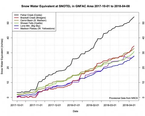
Fisher Creek Snotel site near Cooke City received over 8” of SWE from January 26th to February 10th. The GNFAC put out three separate avalanche warnings for the mountains around Cooke City on February 5th, 8th and 9th. On February 10th, a snowmobiler outside of Cooke City triggered and was buried in a large slide. Fortunately, he was quickly uncovered by his partners and unharmed. Starting February 10th the mountains experienced a four day drought, the longest in two months.
Winter returned for the last half of February and early March. By this time the snowpack had gained strength and avalanche activity was limited to storm snow and cornices. The GNFAC issued a blanket LOW danger on March 7th and 8th, which was short lived as storms continued to impact the area. In early April both Big Sky and Bridger Bowl Ski Resorts reported base depths over 100” and Fisher Creek Snotel site in Cooke City had a settled base depth of more than 140”.
On April 8th, the GNFAC issued its last daily advisory with a considerable danger on wind loaded slopes. The end of daily advisories was not the end of winter. Although temps rose above freezing periodically during the first week of April, the snowpack remained cold and dry. Another significant storm April 11th through the 13th deposited over three feet of snow in the Bridger Range and 12-18” elsewhere. Sadly, on April 14th, a skier was killed in an avalanche on Saddle Peak outside Bridger Bowl Ski Resort. The skier was traveling solo and buried for more than an hour. He was recovered by the Bridger Bowl Ski Patrol.
The GNFAC issued 153 daily advisories, the most ever issued during a single forecast season. Doug, Eric and Alex posted 119 videos on youtube that received 234,000 views and 66 videos on Instagram which received 169,000 views. The GNFAC website saw a 106% increase in visits from the previous year, attributed to a better mobile platform and increased social media presence. Overall it was a safe and successful forecast season for the Gallatin National Forest Avalanche Center.
One thought on “Gallatin National Forest Avalanche Center 2017-18 Winter Season Summary”