
Jackson Hole has already gotten 10″ of snow from the storm that is pounding the Tetons right now.
10” of new snow in Rendezvous Bowl and we’re #JHdreaming of cozying up to a waffle in Corbet’s Cabin. – Jackson Hole at 6pm today
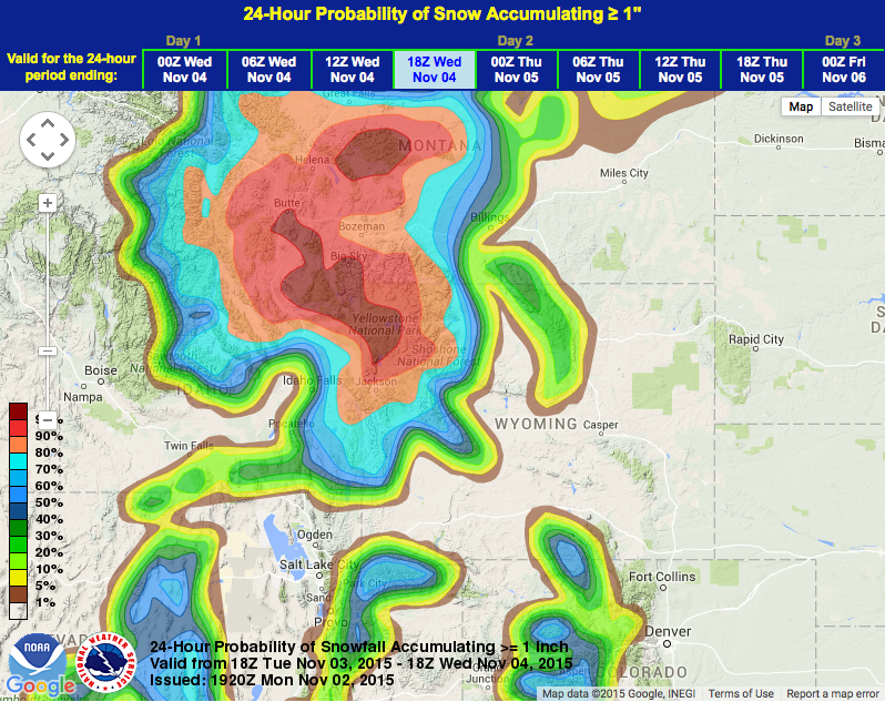
NOAA has a Winter Weather Advisory in effect for Jackson Hole until tomorrow at 5pm that calls for 4-8 more inches of snow to fall.
Jackson Hole is scheduled to open on November 26th.
NOAA’s WINTER WEATHER ADVISORY for JACKSON HOLE:
URGENT - WINTER WEATHER MESSAGE
NATIONAL WEATHER SERVICE RIVERTON WY
153 PM MST MON NOV 2 2015
YELLOWSTONE NATIONAL PARK-TETON AND GROS VENTRE MOUNTAINS-
INCLUDING THE CITIES OF...LAKE...MAMMOTH...OLD FAITHFUL

...WINTER WEATHER ADVISORY REMAINS IN EFFECT UNTIL 5 PM MST
TUESDAY...

* TIMING...GENERALLY LIGHT SNOW OVER THE TETONS AND GROS VENTRE
  RANGES WILL CONTINUE THROUGH THE AFTERNOON AND THEN LIKELY
  DECREASE TO FLURRIES OR EVEN END TONIGHT FOR A WHILE BEFORE
  INCREASING AGAIN ON TUESDAY. LIGHT TO MODERATE SNOW WILL
  CONTINUE OVER YELLOWSTONE NATIONAL PARK INTO THE EVENING HOURS
  BEFORE DECREASING OR RETREATING TO THE FAR WESTERN AND NORTHERN
  SECTIONS OF THE PARK LATER TONIGHT. THE SNOW WILL BECOME MORE
  WIDESPREAD IN THE PARK AGAIN DURING THE DAY TUESDAY.

* SNOWFALL AMOUNTS...EXPECT TOTAL SNOWFALL ACCUMULATIONS THROUGH
  TUESDAY AFTERNOON OF 4 TO 8 INCHES.

* MAIN IMPACT...PERIODS OF SNOW WILL REDUCE VISIBILITIES TO LESS
  THAN A HALF MILE AT TIMES...CAUSE ROADS TO BECOME SLUSHY OR
  SLICK...AND MAY COMBINE WITH SOUTH WINDS TUESDAY AFTERNOON
  GUSTING 25 TO 30 MPH LEADING TO SIGNIFICANT DRIFTING.