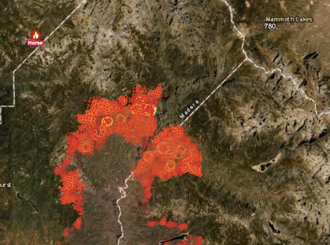
Here is a screenshot from the Mono County #CreekFire information site, and today’s Creek Fire map, that shows the fire as it stands yesterday morning. The fire is still well to the southwest of Mammoth Lakes, and there is NO evacuation warning or order in place today. Air quality remains dangerously bad, and we should all avoid outdoor activity.
US National Weather Service Reno Nevada issued a Red Flag Warning for Mono County starting this afternoon, for high winds and fire danger. As winds pick up over the next two days, Creek Fire incident commanders (IC) expect the fire to move northeast, closer to the Reds Meadow Valley and Mammoth. As we watch and wait, please choose your information sources wisely and don’t pass along rumors. The Creek Fire information page, part of the county’s preparedness portal, has all the right sources at one place: Monocounty.ca.gov/prepared
Here are a few key points for today:
- More Fire Preparation Activity in Mammoth Today: This anticipated change in weather and fire activity will likely mean more visible fire response activity/preparation around Mammoth today: staging equipment, bringing in additional firefighting resources, etc. This is part of the planned fire response. “Planned” is the keyword here. There is a plan for public safety and protection. Working closely together, our local responders (the Inyo National Forest, Mammoth Lakes Fire Dept, Mono County Sheriff, and Town of Mammoth Lakes) and the Creek Fire IC have a plan that ties to forecasted weather and fire activity.
- How Evacuation Notice Works (there is NO EVACUATION WARNING OR ORDER NOW): Mono County Sheriff’s Office is the agency that issues evacuation notices. As Sheriff Braun told us at Tuesday’s Creek Fire update, if a warning or order is issued, residents in the impacted area will receive a notification via CodeRed (which can be phone, text, email) and via cell phone pings to every phone in that area. It’ll also be posted on the town/county websites, on social media, on radio, and via law enforcement patrols.
- Management Action Points (MAPs): Also mentioned in Tuesday night’s community meeting, fire managers set up three Management Action Points (MAPs) that trigger certain preparations and activities as part of their plan. These MAPs are located between the fire’s current location and Reds Meadow/Mammoth Lakes. From today’s Sierra National Forest/Creek Fire IC Update: “Management Action Points (MAPs) have been established as virtual lines on the map in relation to fire location. If the fire crosses any of these MAPs, Emergency Officials will enact appropriate actions to protect life and property.” Last week, the fire crossed the first MAP some 20 miles from Mammoth, and that triggered preparations down at Reds Meadow and Devils Postpile. As of this morning, the fire hadn’t reached the second MAP.
- Fire Maps (actual maps) & Fire Behavior: The daily Creek Fire map doesn’t show Mammoth or Reds Meadow; Mammoth is off the map to the upper right (northeast), about 6 miles from Pumice Butte, a feature that is shown. Here’s some information I’m quoting from Supervisor Fred Stump (a retired fire professional) about reading the daily fire maps, including progression maps. I’ll add that we have to keep in mind that there are some familar place names (Rock Creek, Bald Mountain, etc) on the Sierra National Forest fire maps that refer to locations in Madera and Fresno Counties, and that can cause confusion for Eastside folks. From Supervisor Stump: “I have been asked questions about the fire progression maps which show consistent fire growth to the east and north. Those maps are useful information but do not indicate conditions in the fire’s potential path that will affect its spread. Those conditions include terrain features such as areas of rock outcroppings, fuel type or continuity changes, or old fire scars. This is not new to those familiar with fire behavior. All of these are between this fire’s edge and the trigger points…Having said this, wind can overcome any obstacle.”
- SCE Public Safety Power Shutoff (PSPS): There are no plans/monitoring currently for PSPS in Mono County. Earlier this week, SCE did notify local officials that they were considering putting some circuits in southern Mono and Lee Vining Canyon on “monitoring” status, but they did not. Check PSPS status here (also part of the preparedness portal): https://monocounty.ca.gov/prepared/psps