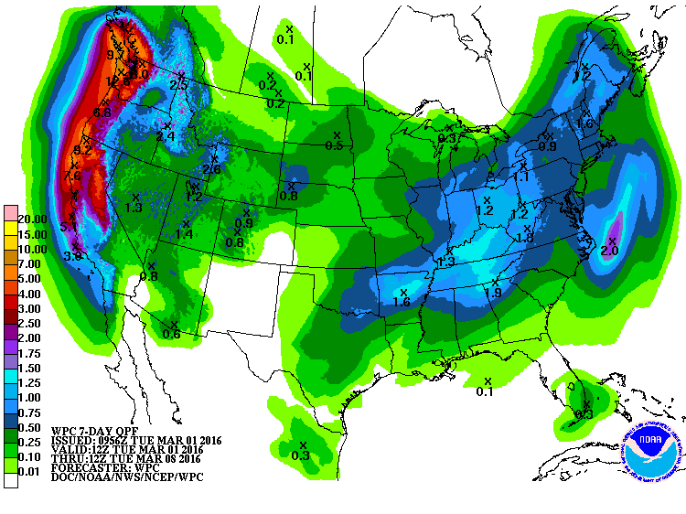
“As has been recently advertised, a more active storm track is becoming more likely and will result in widespread precipitation into this weekend and next week. The image shows the 7-day precipitation forecast across the West.” – NOAA, yesterday
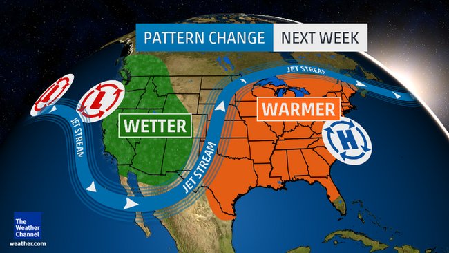
NOAA and more are forecasting a BIG pattern change for the West Coast and the Western USA this week from hot and dry to cold and wet.
Some weather models are showing HUGE snowfall totals for the West Coast in the next 7 days and nearly all models are showing a very stormy month of March in the Western USA.
Miracle March is on its way!
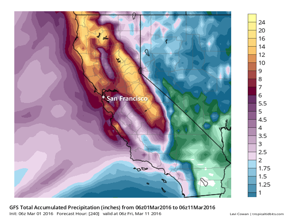
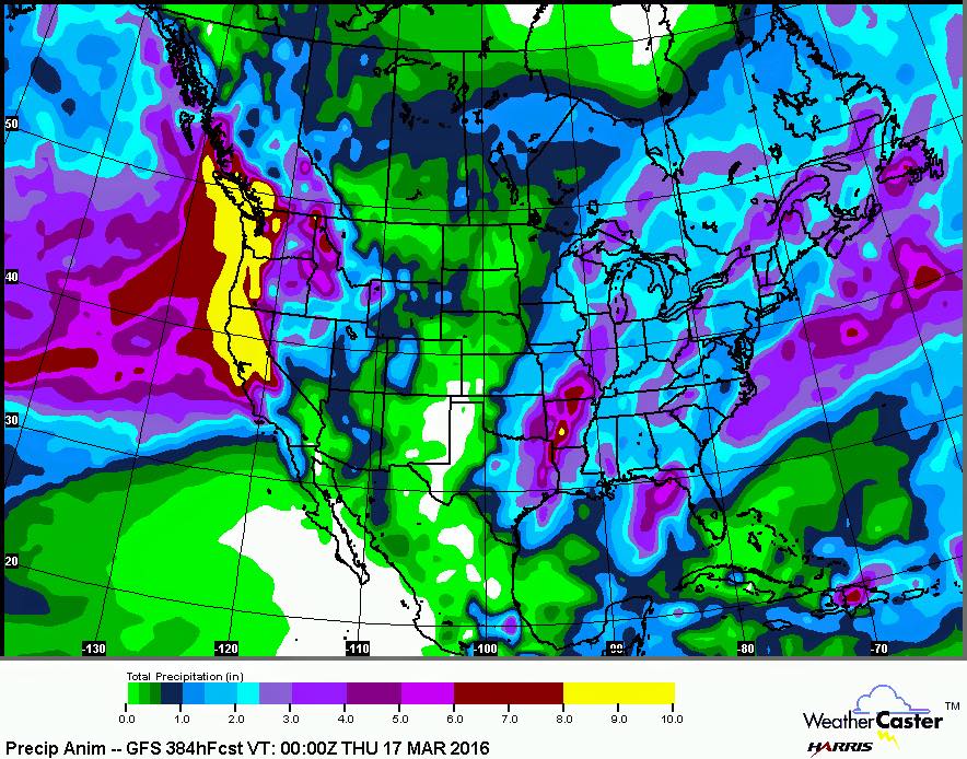
The above model is showing somewhere around 8″ of liquid precipitation for Lake Tahoe, CA between now and March 11th – which, if it all came as snow, would translate to about 8-feet of snow….
California, Oregon, Washington:
Huge precipitation numbers and drowning snowfalls are forecast for the West Coast in the next week. Up to 5-8″ of liquid precipitation is forecast in spots in the next 7-days (which could translate to 5-8 feet of snow…).
Some weather models are forecasting up to 6-Feet of snowfall for Lake Tahoe, CA/NV above 8,000-feet by Monday…
“Can I go out on the limb and forecast 5-10 feet through the latter part of next week.” – Powderchasers.com, forecast for the Sierra Nevada, CA today
Brian Allegretto of Opensnow.com is forecasting 25-42″ of snow above 8,000-feet by Monday.
Mammoth Mountain Weather Guy is forecasting 120-150″ of snowfall for Mammoth in the month of March.
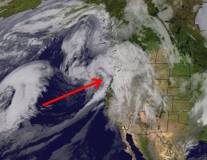
7-day liquid precip totals in CA, OR, WA are looking huge and wild. image: noaa, today
Idaho, Wyoming, Montana:
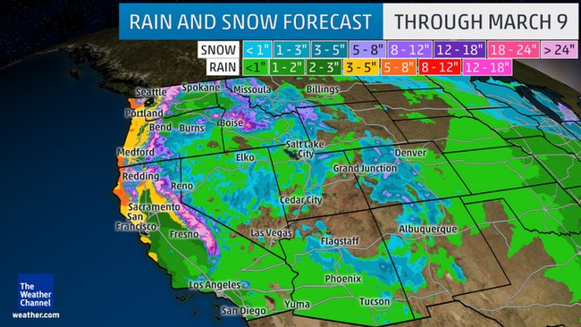
Around 2.5″ of liquid precipitation is forecast in the next 7-days in the northern Rockies, which would translate to around 2.5-feet of snow is the mountains (Jackson Hole, Grand Targhee, Big Sky).
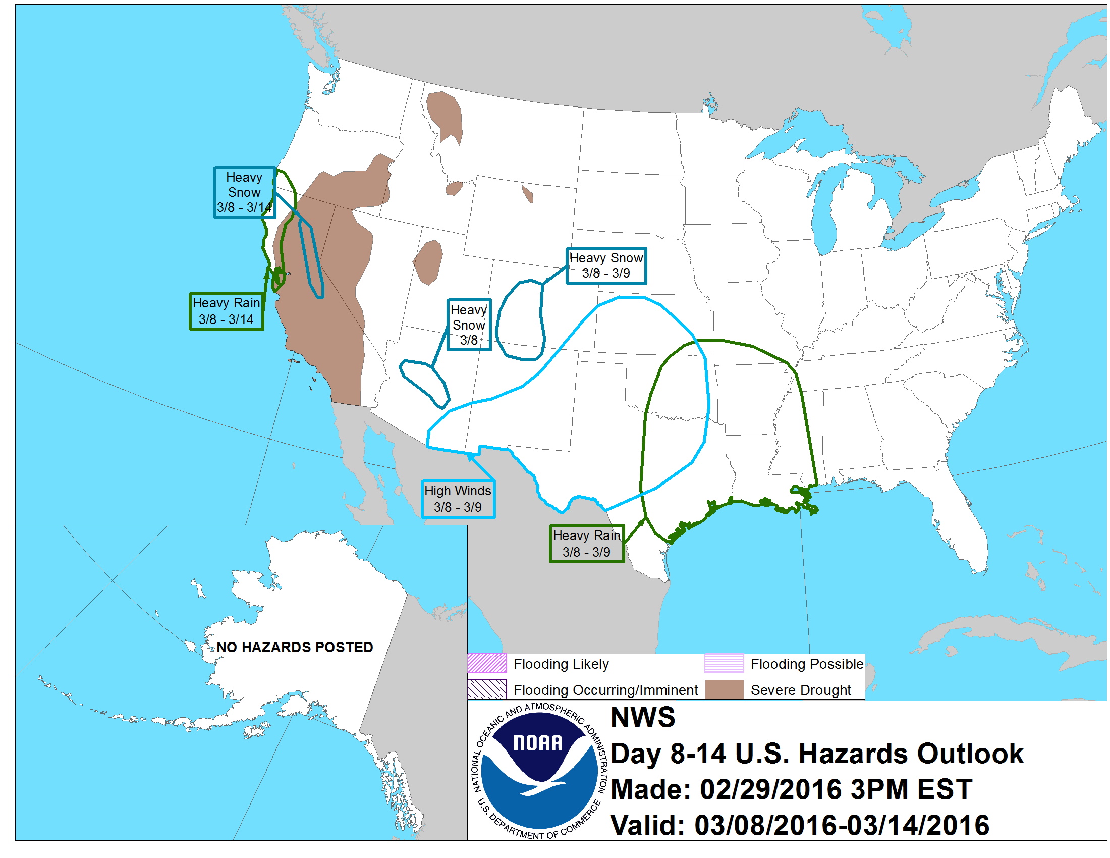
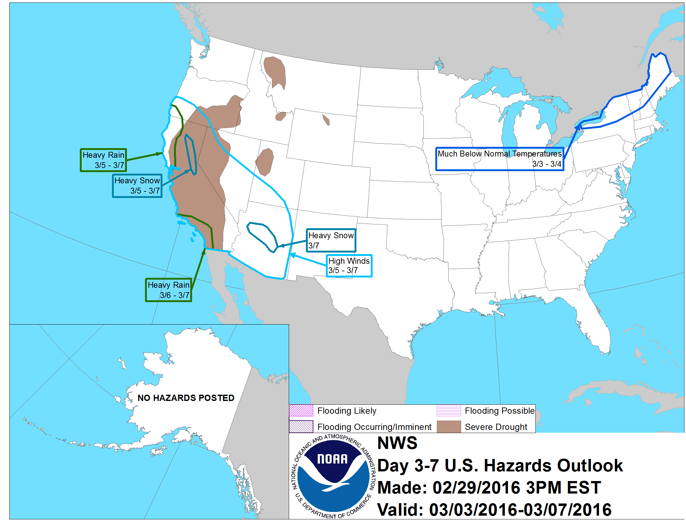
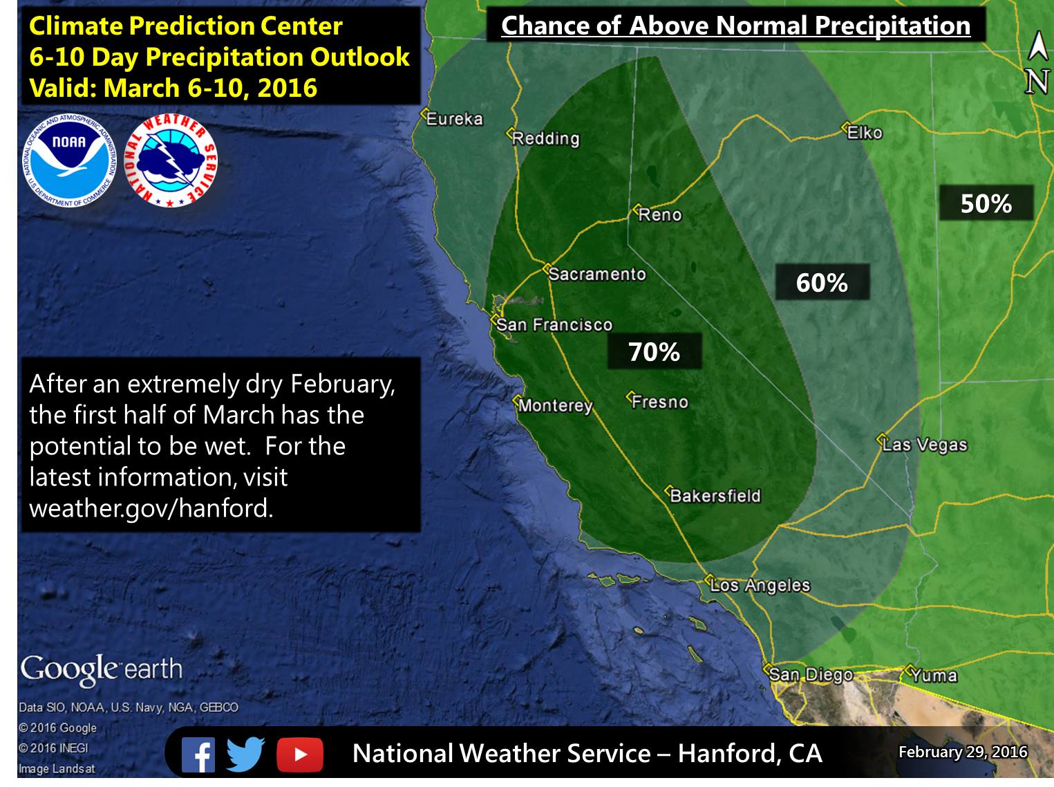
Heavy Snow forecast in CO next week on March 8-9th. Heavy snow forecast in CA from March 8-14th. image: noaa, today
Colorado:
Looking like a snowy week next week with around .8″ of liquid precipitation forecast the next 7-days, which would translate to around a 8″ of snowfall in CO. Local forecasters are calling for even more…
Looking good for snow in the Western USA this week.
Utah:
NOAA is forecasting 1.2″ of liquid forecast for Utah the next 7-days which would translate to around 14″ of snowfall. Powder Mountain & Snowbasin look like they’ll do well in this cycle. Alta, Snowbird, Solitude, and Brighton always seem to get more snow than forecast…
MORE MIRACLE MARCH INFO:
(read the captions under each image for more detail)
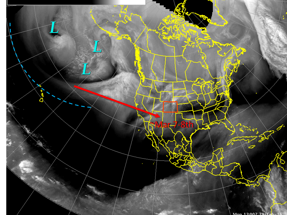
Big pattern change coming to the Western USA this week.Heavy snow forecast in CA on March 5-7th. Heavy snow forecast in AZ on March 7th.
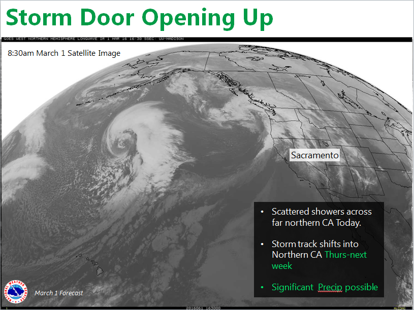
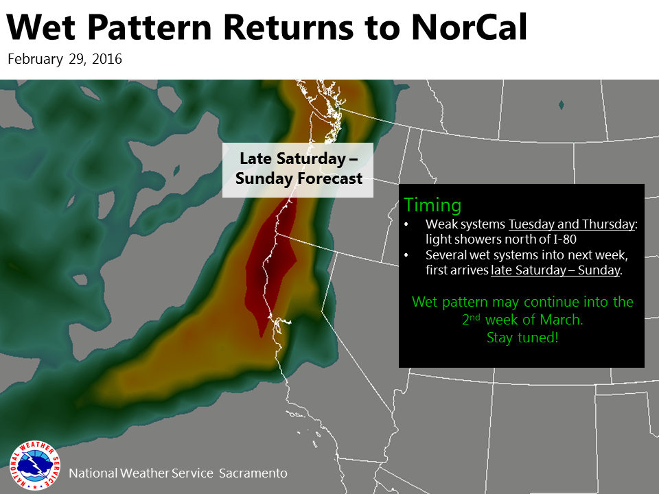
“Major pattern change underway. Significant precipitation possible over NorCal from Thursday into next week.” – NOAA Sacramento, CA today“Wet weather could return to Northern California this weekend and may continue into the 2nd week of March!” – NOAA Sacramento, CA today“Confidence continues to grow for above average precipitation in early March.” – NOAA Hanford, CA today“A lot of storminess in the central and north Pacific right now, seen in the water vapor image from thius morning, will slowly translate eastward until it reaches the Central Rockies sometime early next week. Then, expect a return to cool and unsettled conditons, maybe even some snow for the lowlands” – NOAA, Colorado yesterday“Here comes the moisture!” – NOAA Seattle, WA today“Our sleepy El Niño is back from its slumber to a more typical pattern. This early spring is about to receive a rude awakening! Beginning this weekend a series of storms will barrel in from the Pacific between then, and mid-March. Initially, the snow levels will be relatively high until the trough deepens the snow levels will then drop to perhaps below 2000 feet.” – ABC30 weatherman Kevin Musso, today
Hm…. they’re talking fire danger in the Taos area for now…
But, the pattern change is coming to Taos:
“CHANGES TO THE ATMOSPHERE ARE COMING OVER THE WEEKEND AS THE JET
STREAM TAKES A SOUTHWARD DIP OVER CALIFORNIA…SHIFTING THE STORM
TRACK SOUTH AND ALLOWING FOR MOISTURE ADVECTION ACROSS THE REGION.
EXPECT AN INCREASE IN CLOUDS…COMBINED WITH A BACKDOOR FRONT…TO
PROVIDE SOME COOLING ON SATURDAY. PRECIPITATION CHANCES WILL BEGIN
TO RAMP-UP SUNDAY ACROSS THE WEST AS A LEADING SHORTWAVE TROUGH
PROGRESSES EAST TOWARD THE SOUTHERN ROCKIES. COOLING CONTINUES
INTO EARLY NEXT WEEK WITH PRECIPITATION CHANCES RAMPING UP
FURTHER…FAVORING WESTERN AND SOUTHERN PORTIONS OF NEW MEXICO
WITH THE EVOLUTION OF A POTENT CLOSED UPPER LOW. THE 12Z GFS AND
ECMWF ARE IN GOOD AGREEMENT ON THE PLACEMENT OF THE UPPER LOW
ALONG THE AZ/MEXICO BORDER 12Z TUESDAY. BOTH MODELS DIP THE JET
STREAM FAR SOUTH OVER MEXICO AND LACK A BACKDOOR COLD FRONT TO
GENERATE UPSLOPE AND LOW LEVEL CONVERGENCE OVER OUR AREA…BUT
BOTH DO GENERATE FAIRLY WIDESPREAD QPF. OF NOTE…THE 12Z ECMWF
MEAN PLACES THE 500MB LOW SLIGHTLY FURTHER NORTH THAN THE
OPERATION RUN…AS DOES THE GFS ENSEMBLE MEAN. FURTHERMORE…THE
VARIOUS GFS ENSEMBLE MEMBERS ARE STILL ALL OVER THE PLACE WITH THE
UPPER LOW AT 156HRS…SO THERE IS STILL PLENTY OF UNCERTAINTY ON
THE TRACK. A TRACK THAT IS FURTHER NORTH THAN THE 12Z OPERATIONAL
RUNS WOULD BE MORE PRECIPITATION-FRIENDLY FOR OUR AREA AND WOULD
BE WELCOMED AFTER A RELATIVELY DRY PAST 6 WEEKS ACROSS NORTHERN
AND CENTRAL NEW MEXICO.” – NOAA Albuquerque, NM today
“.LONG TERM…FRIDAY NIGHT THROUGH WEDNESDAY…A PATTERN CHANGE
WILL BRING WET WEATHER…AND CLOSER TO NORMAL TEMPERATURES
STARTING MONDAY…AS A SERIES OF PACIFIC WEATHER SYSTEMS CROSS THE
INTERMOUNTAIN REGION. THE FIRST SYSTEM WILL SPREAD RAIN AND SNOW
SHOWERS ACROSS OUR AREA STARTING LATE FRIDAY NIGHT. MOST OF THE
PRECIPITATION IS EXPECTED TO FALL IN EASTERN OREGON SATURDAY NIGHT
AND SOUTHWEST IDAHO ON SUNDAY…WITH SNOW LEVELS BETWEEN 5000 AND
6000 FEET. A SECOND SYSTEM WILL ARRIVE ON MONDAY. MOST OF ITS
ENERGY WILL MOVE INLAND OVER THE SOUTHWEST STATES AS THE
ASSOCIATED UPPER LEVEL TROUGH DEEPENS OVER THE MEXICAN BORDER
AREA. THIS WILL RESULT IN DECREASING CHANCES OF PRECIPITATION FOR
OUR AREA MONDAY NIGHT AND TUESDAY…BUT SCATTERED SNOW SHOWERS
WILL CONTINUE OVER THE HIGHER TERRAIN ABOVE 4000 FEET…WITH
ISOLATED RAIN SHOWERS IN THE LOWER VALLEYS. MODELS AGREE ON YET
ANOTHER SYSTEM BRINGING WIDESPREAD MOUNTAIN SHOW AND VALLEY RAIN
ON WEDNESDAY. TEMPERATURES WILL BE 10 TO 15 DEGREES ABOVE NORMAL
ON SATURDAY…BUT DAYTIME HIGHS WILL LOWER TO NEAR NORMAL STARTING
MONDAY. OVERNIGHT LOWS WILL STILL BE A FEW DEGREES ABOVE
NORMAL…MAINLY ABOVE FREEZING IN THE TREASURE VALLEY.” – NOAA Boise, ID today
“WEATHER SUMMARY:
A MAJOR PATTERN CHANGE TOWARD MUCH WETTER WEATHER IS ON THE
HORIZON. A FEW WEAK WEATHER SYSTEMS WILL BRING LIGHT
PRECIPITATION TO THE REGION THURSDAY AND FRIDAY. A MUCH STRONG
SYSTEM ARRIVES ON SATURDAY AND SATURDAY NIGHT, LIKELY BRINGING
HEAVY PRECIPITATION, GUSTY WINDS, AND HEAVY MOUNTAIN SNOW. WEATHER
SYSTEMS CONTINUE INTO EARLY NEXT WEEK.” – NOAA Sacramento, CA today
A huge amount of precipitation is heading there way next week. Snow levels will be the concern.
3-8″ of snow above 3,000-feet is forecast tonight for the WA Cascades.
So far, NOAA hasn’t been specific at all yet about next week:
“.LONG TERM…THERE WILL CONTINUE TO BE PERIODS
OF RAIN OR SHOWERS WITH BREAKS BETWEEN SYSTEMS. THE 12Z GFS SHOWED A
RUN OF THE MILL FRONT ARRIVING FRIDAY MORNING…A STRONGER SYSTEM
FRIDAY NIGHT INTO SATURDAY MORNING…AND YET ANOTHER WEATHER SYSTEM
ON SUNDAY. THE SYSTEM ON SUNDAY HAS A 974MB LOW CENTER THAT MOVES
NORTH THROUGH THE COASTAL OR NEAR OFFSHORE WATERS SUNDAY NIGHT.” – NOAA Seattle, WA today

How about the East side of the divide in CO. Dumont Georgetown Idaho Springs
What about Wofford Heights,Ca.93285.
Alaska???? We are the United states….kind of…:-)
Any idea about Taos and northern Nee Mexico?
Hm…. they’re talking fire danger in the Taos area for now…
But, the pattern change is coming to Taos:
“CHANGES TO THE ATMOSPHERE ARE COMING OVER THE WEEKEND AS THE JET
STREAM TAKES A SOUTHWARD DIP OVER CALIFORNIA…SHIFTING THE STORM
TRACK SOUTH AND ALLOWING FOR MOISTURE ADVECTION ACROSS THE REGION.
EXPECT AN INCREASE IN CLOUDS…COMBINED WITH A BACKDOOR FRONT…TO
PROVIDE SOME COOLING ON SATURDAY. PRECIPITATION CHANCES WILL BEGIN
TO RAMP-UP SUNDAY ACROSS THE WEST AS A LEADING SHORTWAVE TROUGH
PROGRESSES EAST TOWARD THE SOUTHERN ROCKIES. COOLING CONTINUES
INTO EARLY NEXT WEEK WITH PRECIPITATION CHANCES RAMPING UP
FURTHER…FAVORING WESTERN AND SOUTHERN PORTIONS OF NEW MEXICO
WITH THE EVOLUTION OF A POTENT CLOSED UPPER LOW. THE 12Z GFS AND
ECMWF ARE IN GOOD AGREEMENT ON THE PLACEMENT OF THE UPPER LOW
ALONG THE AZ/MEXICO BORDER 12Z TUESDAY. BOTH MODELS DIP THE JET
STREAM FAR SOUTH OVER MEXICO AND LACK A BACKDOOR COLD FRONT TO
GENERATE UPSLOPE AND LOW LEVEL CONVERGENCE OVER OUR AREA…BUT
BOTH DO GENERATE FAIRLY WIDESPREAD QPF. OF NOTE…THE 12Z ECMWF
MEAN PLACES THE 500MB LOW SLIGHTLY FURTHER NORTH THAN THE
OPERATION RUN…AS DOES THE GFS ENSEMBLE MEAN. FURTHERMORE…THE
VARIOUS GFS ENSEMBLE MEMBERS ARE STILL ALL OVER THE PLACE WITH THE
UPPER LOW AT 156HRS…SO THERE IS STILL PLENTY OF UNCERTAINTY ON
THE TRACK. A TRACK THAT IS FURTHER NORTH THAN THE 12Z OPERATIONAL
RUNS WOULD BE MORE PRECIPITATION-FRIENDLY FOR OUR AREA AND WOULD
BE WELCOMED AFTER A RELATIVELY DRY PAST 6 WEEKS ACROSS NORTHERN
AND CENTRAL NEW MEXICO.” – NOAA Albuquerque, NM today
Heh what about Brundage in Idaho
Brundage is looking good:
“.LONG TERM…FRIDAY NIGHT THROUGH WEDNESDAY…A PATTERN CHANGE
WILL BRING WET WEATHER…AND CLOSER TO NORMAL TEMPERATURES
STARTING MONDAY…AS A SERIES OF PACIFIC WEATHER SYSTEMS CROSS THE
INTERMOUNTAIN REGION. THE FIRST SYSTEM WILL SPREAD RAIN AND SNOW
SHOWERS ACROSS OUR AREA STARTING LATE FRIDAY NIGHT. MOST OF THE
PRECIPITATION IS EXPECTED TO FALL IN EASTERN OREGON SATURDAY NIGHT
AND SOUTHWEST IDAHO ON SUNDAY…WITH SNOW LEVELS BETWEEN 5000 AND
6000 FEET. A SECOND SYSTEM WILL ARRIVE ON MONDAY. MOST OF ITS
ENERGY WILL MOVE INLAND OVER THE SOUTHWEST STATES AS THE
ASSOCIATED UPPER LEVEL TROUGH DEEPENS OVER THE MEXICAN BORDER
AREA. THIS WILL RESULT IN DECREASING CHANCES OF PRECIPITATION FOR
OUR AREA MONDAY NIGHT AND TUESDAY…BUT SCATTERED SNOW SHOWERS
WILL CONTINUE OVER THE HIGHER TERRAIN ABOVE 4000 FEET…WITH
ISOLATED RAIN SHOWERS IN THE LOWER VALLEYS. MODELS AGREE ON YET
ANOTHER SYSTEM BRINGING WIDESPREAD MOUNTAIN SHOW AND VALLEY RAIN
ON WEDNESDAY. TEMPERATURES WILL BE 10 TO 15 DEGREES ABOVE NORMAL
ON SATURDAY…BUT DAYTIME HIGHS WILL LOWER TO NEAR NORMAL STARTING
MONDAY. OVERNIGHT LOWS WILL STILL BE A FEW DEGREES ABOVE
NORMAL…MAINLY ABOVE FREEZING IN THE TREASURE VALLEY.” – NOAA Boise, ID today
you should check out Tamarack, ID… looks great here
How about south Sacramento? What will we see? It seemed the last few storms missed us, barely.
Special Weather Statement for Sac right now:
“WEATHER SUMMARY:
A MAJOR PATTERN CHANGE TOWARD MUCH WETTER WEATHER IS ON THE
HORIZON. A FEW WEAK WEATHER SYSTEMS WILL BRING LIGHT
PRECIPITATION TO THE REGION THURSDAY AND FRIDAY. A MUCH STRONG
SYSTEM ARRIVES ON SATURDAY AND SATURDAY NIGHT, LIKELY BRINGING
HEAVY PRECIPITATION, GUSTY WINDS, AND HEAVY MOUNTAIN SNOW. WEATHER
SYSTEMS CONTINUE INTO EARLY NEXT WEEK.” – NOAA Sacramento, CA today
Heading to Tahoe the last week in March. Any long range forecasts?
3 to 8 inches ? That’s not so bad. Or did you mean feet ? ” is inches. , AMAZING
What about northern Arizona?
Hey Janeen, there is that one NOAA image in this article showing “heavy snow” for Arizona on March 8th. Fingers crossed. thanks.
You discussed California’s predictions but what about WA.?
Hey Greg,
A huge amount of precipitation is heading there way next week. Snow levels will be the concern.
3-8″ of snow above 3,000-feet is forecast tonight for the WA Cascades.
So far, NOAA hasn’t been specific at all yet about next week:
“.LONG TERM…THERE WILL CONTINUE TO BE PERIODS
OF RAIN OR SHOWERS WITH BREAKS BETWEEN SYSTEMS. THE 12Z GFS SHOWED A
RUN OF THE MILL FRONT ARRIVING FRIDAY MORNING…A STRONGER SYSTEM
FRIDAY NIGHT INTO SATURDAY MORNING…AND YET ANOTHER WEATHER SYSTEM
ON SUNDAY. THE SYSTEM ON SUNDAY HAS A 974MB LOW CENTER THAT MOVES
NORTH THROUGH THE COASTAL OR NEAR OFFSHORE WATERS SUNDAY NIGHT.” – NOAA Seattle, WA today
Why did you skip over Nevada And not forecast for them?
Hey Joe, I’ll get them in there. We often lump the Lake Tahoe, NV ski resorts in with the Lake Tahoe, CA resorts and forget to differentiate. Thanks.