
The San Juan mountain range of Colorado (Telluride, Silverton) is currently under a Blizzard Warning, a Winter Storm Warning, and an Avalanche Warning.
2-4 feet of new snow is expected from the current storm that is expected to finally blow through on Tuesday evening.
Unofficial Amounts through entire storm:
Wolf Creek Pass – 42 inches
Telluride – 31 inches
Silverton – 30 inches
Crested Butte – 29 inches – NOAA Grand Junction

As of March 2nd, Telluride has already gotten 31″ of snow, Silverton has already gotten 30″ of snow, and Wolf Creek has already gotten 42″ of snow out of this storm and 8-12 more inches are expected tonight and tomorrow.
NOAA Grand Junction, CO:
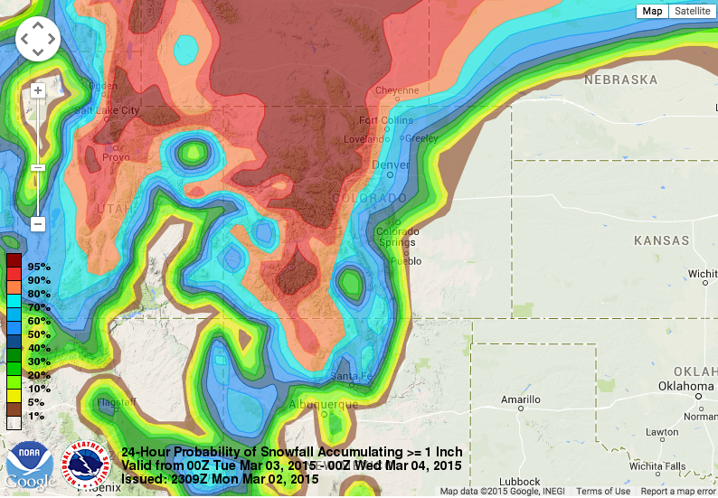
Blizzard Warnings have been issued above 10,000 feet for the San Juans and also a portion of the southern central mountains (the red in the first graphic). The other graphic below shows the jet stream of 170 mph moving right over our forecast area. The strong winds will mix down and continue to increase through the evening hours and with some snow expected, blizzard conditions of 1/4 visibility or less and gusts of 35 mph are anticipated from time to time. Travel will be difficult, if not impossible, over mountain passes at times as whiteout conditions occur. – NOAA Grand Junction
NOAA’s Blizzard Warning:
URGENT - WINTER WEATHER MESSAGE
NATIONAL WEATHER SERVICE GRAND JUNCTION CO
726 PM MST MON MAR 2 2015

...BLIZZARD WARNING REMAINS IN EFFECT UNTIL 6 AM MST TUESDAY
ABOVE 10000 FEET...
...WINTER STORM WARNING REMAINS IN EFFECT UNTIL 5 PM MST
TUESDAY...

* LOCATIONS INCLUDE THE CITIES OF...OURAY...TELLURIDE...LAKE
  CITY...SILVERTON...RICO...HESPERUS.

* TIMING...HEAVY SNOW AND BLOWING SNOW ARE EXPECTED TONIGHT.
  THUNDERSNOW WILL BE POSSIBLE DURING THE EVENING. SNOW
  CONTINUES THROUGH TUESDAY AFTERNOON.

* SNOW ACCUMULATION...8 TO 12 INCHES OF ADDITIONAL SNOWFALL...
  WITH 2 TO 4 FEET STORM TOTAL SNOWFALL. DRIFTS IN EXCESS OF 6
  FT WILL BE POSSIBLE. THE HEAVIEST SNOWFALL SHIFTS FROM THE
  SOUTHWEST SLOPES EARLY THIS EVENING TO THE NORTHWEST SLOPES BY
  TUESDAY.

* WINDS...SOUTHWEST 20 TO 30 MPH WITH GUSTS UP TO 50 MPH TONIGHT
  WITH THE STRONGEST WINDS FROM MID EVENING UNTIL MIDNIGHT.

* VISIBILITY...ABOVE 10000 FEET TONIGHT...BELOW ONE QUARTER MILE
  AT TIMES IN WHITEOUT CONDITIONS. OTHERWISE REDUCED VISIBILITY
  AT TIMES IN SNOW AND BLOWING SNOW.