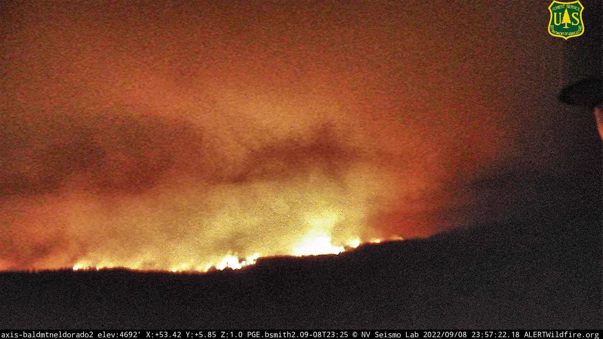
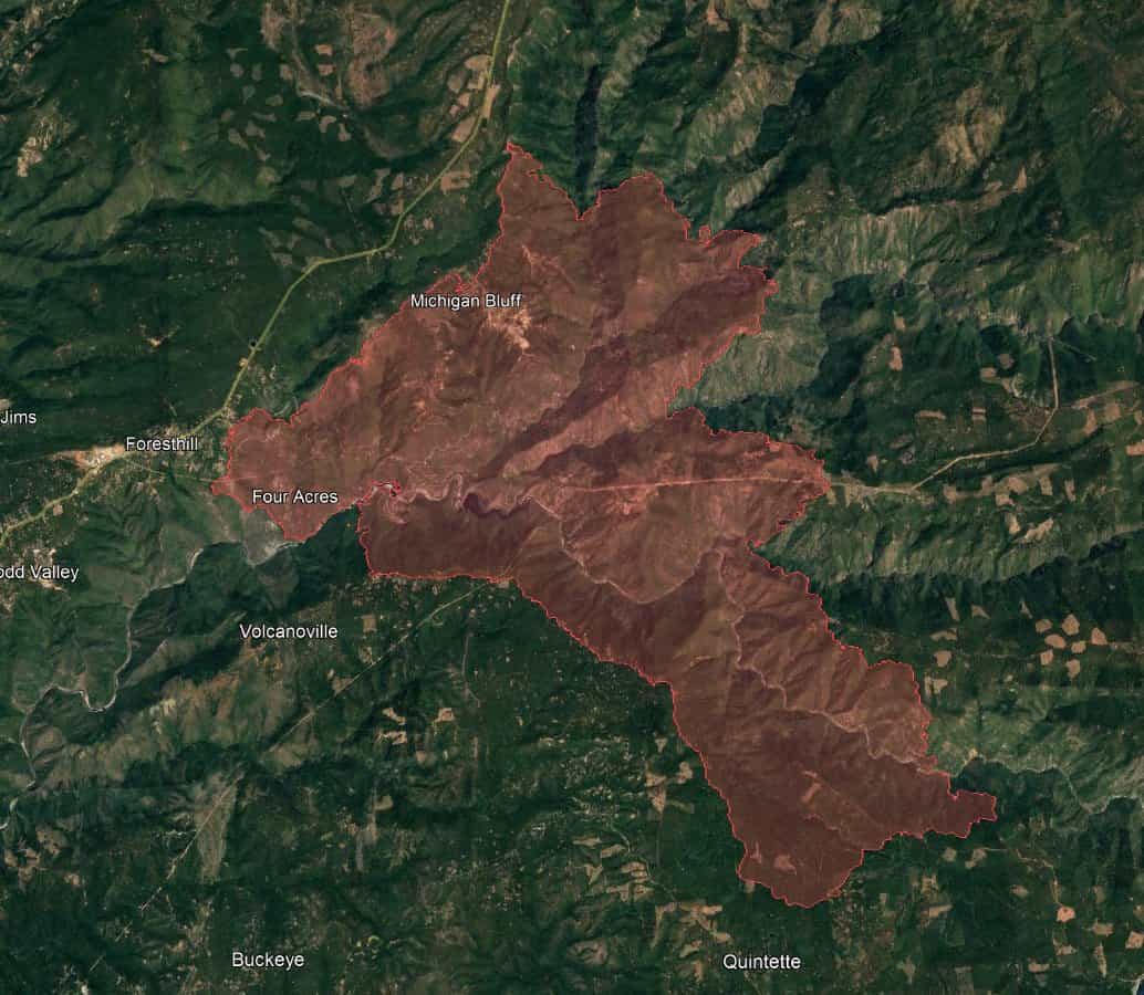
The Mosquito Fire burning in Placer County, CA, exploded to 25,108 acres yesterday and crossed into El Dorado County, according to fire authorities. It is currently 0% contained. Bloomberg is reporting that the fire was started by a fault in a PG&E Corp. power line in the Sierra Nevada foothills.
#MosquitoFire (#Foresthill, Placer Co/El Dorado Co) – The fire was mapped at 25,108 acres as of approx 11:10pm tonight. Most of that growth has come on the south eastern side. Map link: https://t.co/tmP4qp8yEY pic.twitter.com/4Jhcd0BdZ8
— CA Fire Scanner (@CAFireScanner) September 9, 2022
The fire, which started on Tuesday, September 6th, 2022 at 6:30 pm, is burning actively near Oxbow Reservoir, three miles east of Foresthill, in brush and timber in very steep and rugged terrain.
“The fire is burning in extremely difficult terrain including steep canyons where directly attacking the fire can be difficult.”
– Cal Fire

Smoke from the fire is affecting air quality in the Sacramento Valley and Lake Tahoe areas. Sacramento Metropolitan Air Quality Management District issued a smoke advisory last night.
Snowing ash and apocalypse views in North Lake Tahoe right now. #mosquitofire pic.twitter.com/H6OUoF9qIx
— Cody Townsend (@codytownsend) September 9, 2022
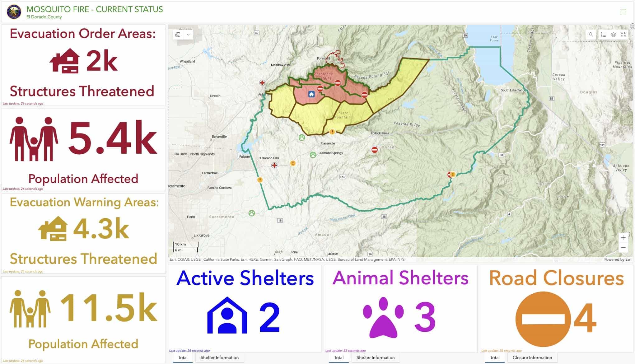
Placer County has proclaimed a local emergency due to the ongoing threat from the Mosquito Fire. Foresthill and nearby communities in both Placer and El Dorado counties remain under evacuation orders and warnings.
Like a volcano exploding.
A massive pyrocumulus plume has developed on the #MosquitoFire in NorCal as it spreads rapidly in the hot and unstable airmass of the ongoing heatwave. #CAwx #CAfire pic.twitter.com/55jHvLCGFK
— Colin McCarthy (@US_Stormwatch) September 7, 2022
A local emergency proclamation asserts continuing risk to life and property and that the response is beyond the capabilities of local resources. Placer’s proclamation requests state and federal assistance, but neither a state nor a federal disaster has yet been declared that would authorize individual disaster assistance for residents and businesses.
Additionally, updated evacuation warnings from the @ElDoradoSheriff have been announced. pic.twitter.com/c0zlff1XB5
— CAL FIRE Nevada-Yuba-Placer Unit (@CALFIRENEU) September 9, 2022
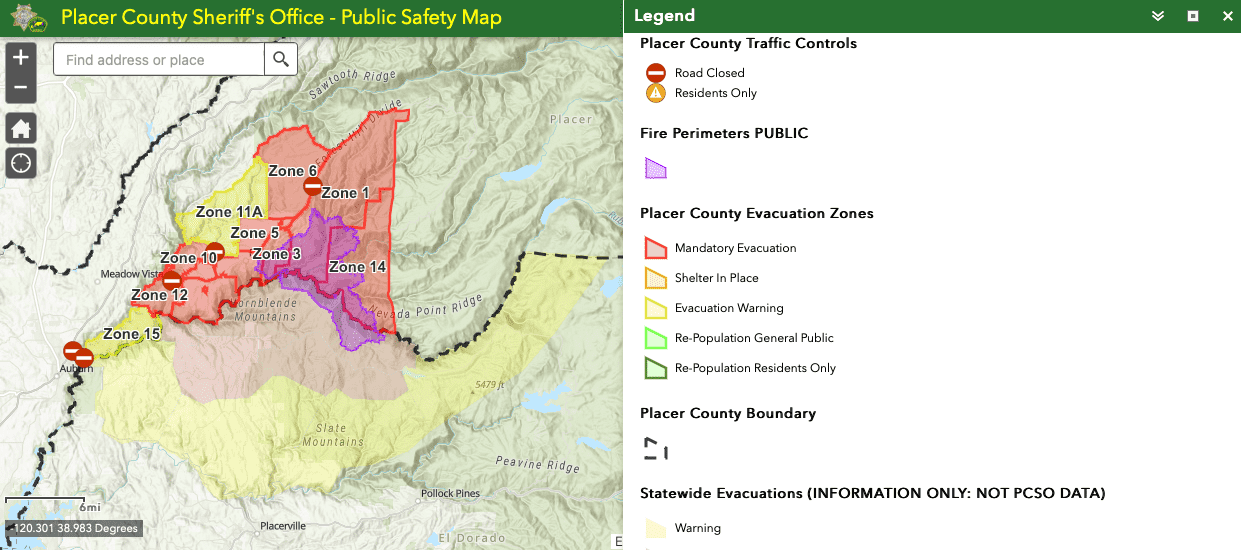
Evacuation Orders
Placer County Evacuation Orders
Zone 1 – Michigan Bluff
- Michigan Bluff Rd
- Gorman Ranch Rd
- Chicken Hawk Rd
- Ridge View Rd
- Deadwood Rd
Zone 2 – Baker Ranch
- Mobile Home Park
Zone 3 – Crystal View Rd and Bath Rd
Zone 4 – Foresthill
- Foresthill Rd from Idlewild Rd to Bath Rd
- Powerline Rd
- Timberland Rd
- Sluce Box Ln
Zone 5
- Black Oak Ridge Rd
- Blackhawk Ln
- Ebbert Ranch Rd
- Old Ebberts Ranch Rd
Zone 6
- Finning Mill Rd to Sugar Pine Rd to Elliot Ranch Rd to Forestill Rd
- Big Reservoir Rd
- Giant Gap Rd
- Hollow Log Rd
- Prospect Rd, NF-10
Zone 7 – Todd Valley
- South of Foresthill Road
- North of the middle fork of the American River
- West of Jarvis to include Patent
- East of McKeon Ponderosa to the American River
El Dorado County Evacuation Orders
For a map of current evacuation orders and warnings in El Dorado County, please visit: https://www.facebook.com/eldoradosheriff
EVACUATION ORDERS are in effect for the following communities:
Volcanoville: Residents who live north of Wentworth Springs, east of Otter Creek, South of the Placer County Line, and west of Tunnel Hill Road are under mandatory evacuation orders. Please evacuate the area immediately.
Evacuation Warnings
Placer County Evacuation Warnings
For a map of current evacuation orders and warnings in Placer County, please visit: https://experience.arcgis.com/experience/07930e6e8f034ae4bba71e8bfedb2779/page/Sheriff-Evacuations-PCSO/
An EVACUATION WARNING is in effect for the following community:
Zone 8 – Sky View (21200 Todd Valley Road)
- Sky View Mobile Home Park
Zone 9 – North Side of Foresthill Road
- North of Foresthill Road
- South of Yankee Jims Road through Spring Garden to include Owl Creek and Pine Mountain
- Everything west of Power Line and Hard Rock
Zone 10 – Spring Garden / Whitehawk Ridge
- North of Spring Garden Rd. and east of Ponderosa Rd. to the North Fork of the American River
- South of the North Fork of the American River
- South of Yankee Jims Road to Spring Garden
Zone 11 – Yankee Jims and Shirttail Canyon
- North of Yankee Jims Road to include Shirttail Canyon
- South of Big Dipper through Kings Hill and through Black Bear and Grills Hill
- West of Finning Mill Road
El Dorado County Evacuation Warnings
For a map of current evacuation warnings and orders in El Dorado County, please visit: https://www.facebook.com/eldoradosheriff
An EVACUATION WARNING is in effect for the following community:
- Quintette: Residents who live north of Wentworth Springs, east of Lofty Peak Lane, South of the Placer County Line, and west of Blackeye Pea Road need to prepare to evacuate if this warning becomes a mandatory evacuation. Please use this time to gather belongings and prepare. There will be deputies in the area going door to door to notify residents. Be prepared to evacuate if this warning becomes mandatory.
Evacuation Centers
Placer County – Bell Road Baptist Church: 77 Bell Road, Auburn, CA 95603
El Dorado County (Temporary Evacuation Point) – Cool Community Church at 863 Cave Valley Rd, Cool, CA 95614

When will that criminal enterprise know as PG&E be dissolved and remade as a consumer corporation. We pay for there profit’s with our tax money. We should own water, power and sewer production. Power to the people!!!