Forecast By SnowBrains Meteorologist – Eric McNamee
4:20 PM MST
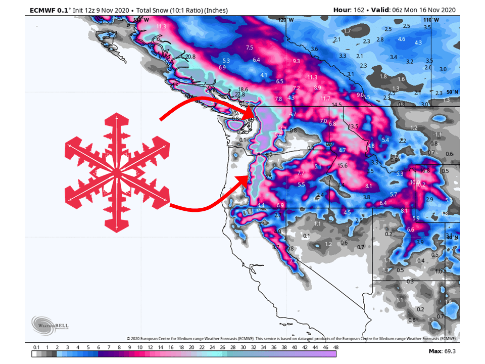
Forecast Summary:
Over the next week, additional FEET of snow is expected across the western US as an active weather pattern continues.
The highest amounts will be found in the Pacific NW and Northern Rockies.
Snowfall will come in waves as shortwave troughs make their way through the west.
Active weather looks to continue through the extended forecast.
Short-Term Forecast:
Monday-Wednesday:
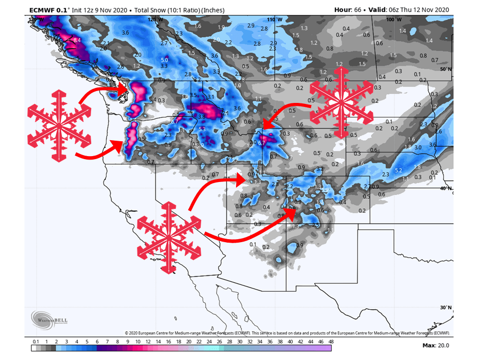
12-16″ of snow is expected in the Cascades through Wednesday as the first of a series of shortwave troughs moves through the western US.
Around a foot of snow is expected in eastern Idaho and Western Wyoming from prolonged moist flow from the west, favoring the Tetons.
An additional 2-6″ of snow is expected in portions of Colorado and Utah from the current trough over the area.
Long-Term Forecast:
Thursday-Sunday:
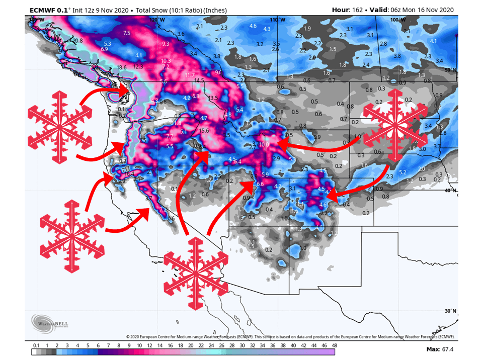
An additional 1-3 FEET of snow is likely from the second and third systems in a series of shortwave troughs looking to move through the west heading into the weekend.
The bulk of this looks to be in the west’s northern portions, favoring the Cascades and the Northern Rockies, seeing 1-3 FEET of snow.
During this time, the Sierra will get in on the action, possibly seeing 8-12″ of snow.
The Wasatch Mountains of Utah and mountains of Colorado look to see the possibility of an additional 8-12″ of snow as well.
These numbers in the long-term are subject to change as we get closer to the time of storm passages.
Extended Forecast:
Sunday and Beyond:
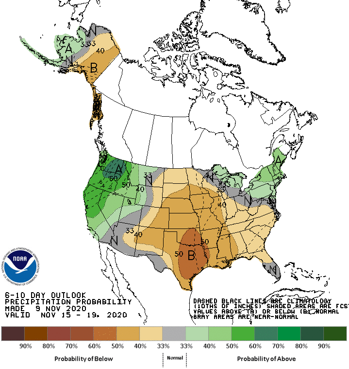
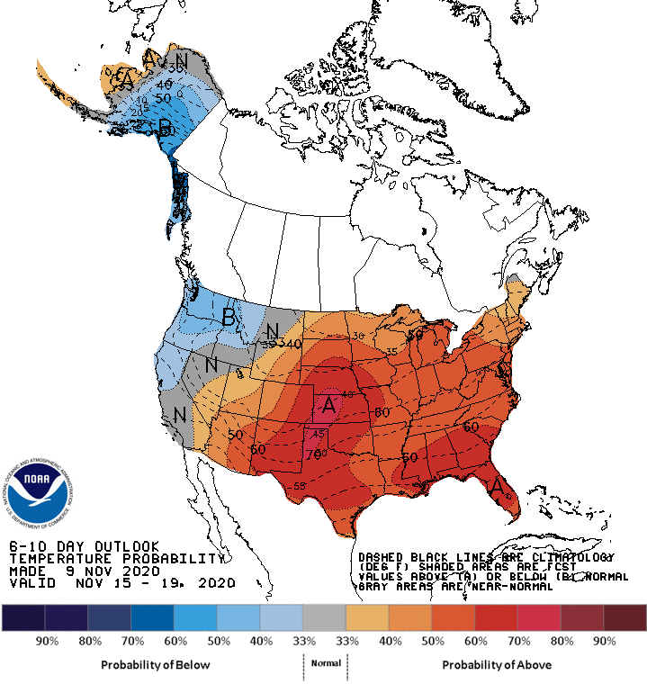
Since last week, global ensembles have been indicating active weather to continue over the western US.
This morning’s model runs continue to show this solution, meaning more snow is likely past this week in the west.
Depending on how far north or south the storm track is will determine where the snow will fall and that is still uncertain at this time
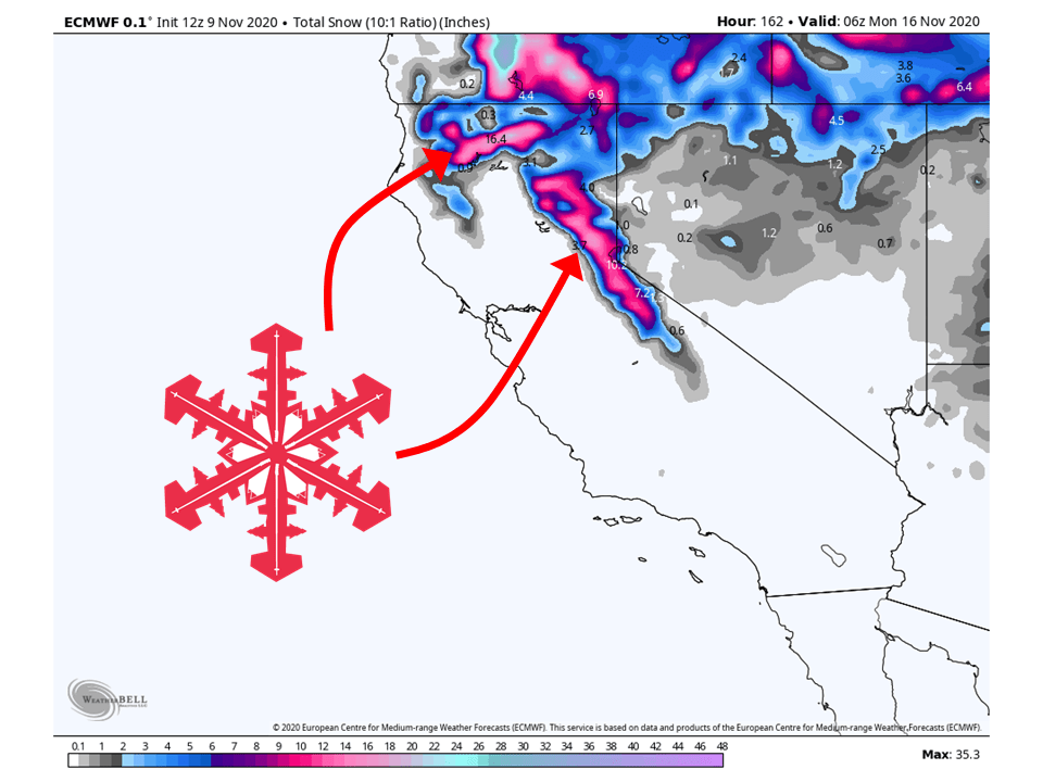
California:
Through the workweek, the Sierras will likely miss out on the snow as the storm track stays to the north.
However, models are indicating the possibility of 8-12″ of snow this weekend.
Resorts that are likely to see the most snow Squaw Alpine, Sugar Bowl, Kirkwood, Heavenly, and Northstar.
Colorado:
Colorado is expected to see an additional 2-6″ of snow through Wednesday as the current shortwave trough moves off the east.
Heading into this weekend, another round of snow is expected across the mountain of Colorado, possibly seeing 8-12″ of snow.
Resorts that look to see the most snow are Aspen, Steamboat, Wolf Creek, and Winter Park.
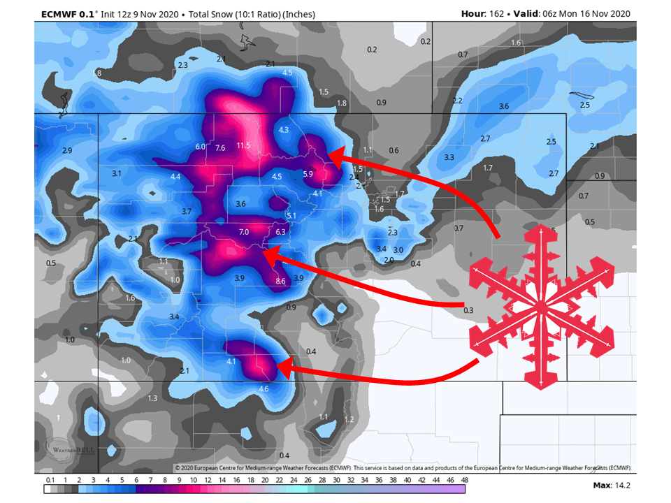
Utah:
Like Colorado, Utah will see an additional 2-6″ of snow through Wednesday from the current shortwave trough.
Heading into the weekend, more rounds of snow are expected, especially along the Wasatch Mountains.
Right now, the models are showing anywhere from 8-12″ of snow this weekend.
Resorts that look to be favored are Snowbasin, Powder Mountain, Beaver Mountain, Alta, Snowbird, Brighton, Solitude, Park City, Canyons, Deer Valley, and Sundance.
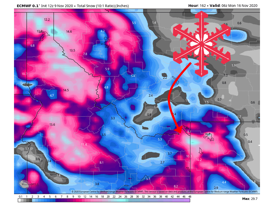
Northern Rockies:
The Northern Rockies look to do pretty well, with 8-12″ of snow likely falling through Wednesday along the Tetons.
Heading into the weekend, most mountain locations could possibly see an additional 12-18″ of snow.
Resorts that look to see the most snow are Jackson Hole, Targhee, Big Sky, Big Moutain, Sun Valley, and Schweitzer.
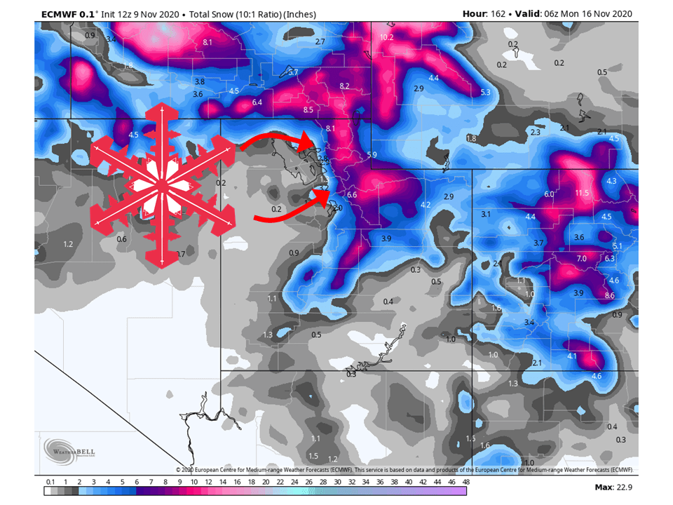
Pacific Northwest:
The Pacific Northwest looks to get HAMMERED with snow over the next week, likely seeing 1-3 FEET of snow and higher amounts in localized areas favored by flow from the west.
The main bulk of this looks to come this weekend as models hint at the possibility of a potent winter storm for the area.
Resorts that look to see the most snow are Mt. Bachelor Timberline Lodge, Crystal Mountain, Alpental, and Mt Baker.
USA:
Global ensembles continue to show above-average precipitation and below-average temperatures across the western US.