For the second year in a row, the cooler sister to El Niño showed up at the winter party in the Eastern Pacific. La Niña is expected to stick around until at least spring 2022 in the Northern Hemisphere.
Part of the El Niño-Southern Oscillation cycle, La Niña appears when energized easterly trade winds intensify the upwelling of cooler water from the depths of the eastern tropical Pacific, causing a large-scale cooling of the eastern and central Pacific ocean surface near the Equator. These stronger than usual trade winds also push the warm equatorial surface waters westward toward Asia and Australia. This dramatic cooling of the ocean’s surface layers then affects the atmosphere by modifying the moisture content across the Pacific. This La Niña coupling of the atmosphere and ocean alters global atmospheric circulation and can cause shifts in the path of mid-latitude jet streams in ways that intensify rainfall in some regions and bring drought to others.
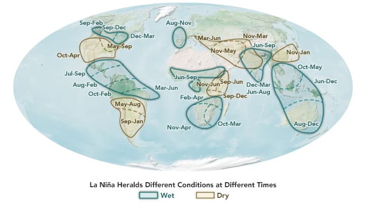
In the western Pacific, rainfall can increase dramatically over Indonesia and Australia during La Niña. Clouds and rainfall become more sporadic over the central and eastern Pacific Ocean, which can lead to dry conditions in Brazil, Argentina, and other parts of South America and wetter conditions over Central America. In North America, cooler and stormier conditions often set in across the Pacific Northwest, while weather typically becomes warmer and drier across the southern United States and northern Mexico. (These and other trends are reflected in the map lower in this story.)
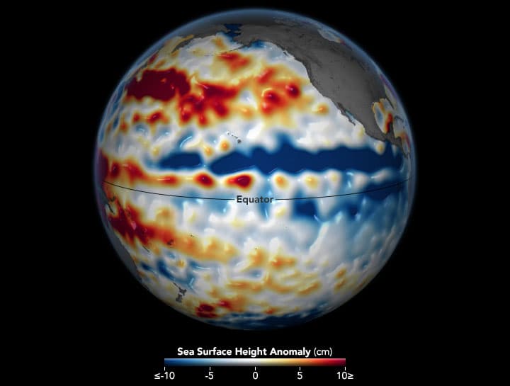
The image above shows conditions across the central and eastern Pacific Ocean as observed from November 26 to December 5, 2021, by the Sentinel-6 Michael Freilich satellite and analyzed by scientists at NASA’s Jet Propulsion Laboratory (JPL). The globe depicts sea surface height anomalies. Shades of blue indicate sea levels that were lower than average; normal sea-level conditions appear white, and reds indicate areas where the ocean stood higher than normal. The expansion and contraction of the ocean surface is a good proxy for temperatures because warmer water expands to fill more volume, while cooler water contracts.
“This moderate strength La Niña can be seen in the Sentinel-6 data as an area of lower-than-normal sea level along and below the Equator in the central and eastern Pacific,” said Josh Willis, a climate scientist and oceanographer at JPL. He noted that the deep trough (blue) above the Equator is not the La Niña water mass; it is a shift in the North Equatorial Counter Current, which tends to strengthen during La Niña events.
“This La Niña probably means bad news for the American Southwest, which should see lower than normal rainfall this winter. This La Niña may not be a whopper, but it’s still an unwelcome sign for an area already deep into a drought.”
– Josh Willis
The La Niña event that started in late 2020 fits into a larger climate pattern that has been going on for nearly two decades—a cool (negative) phase of the Pacific Decadal Oscillation (PDO). During most of the 1980s and 1990s, the Pacific was locked in a PDO warm phase, which coincided with several strong El Niño events. But since 1999, a cool phase has dominated. The long-term drought in the American Southwest coincides with this trend, Willis noted.
In a report released on December 9, 2021, the NOAA Climate Prediction Center noted that sea surface temperatures in November in the eastern tropical Pacific ranged from 0.7 to 1.2 degrees Celsius below the long-term average and 0.9°C below average in the Niño 3.4 region of the tropical Pacific (from 170° to 120° West longitude). Forecasters predicted La Niña conditions would persist through Northern Hemisphere winter, with a 60 percent chance that the ocean would transition back to neutral conditions during the April through June period.
This La Niña is the first to be observed by Sentinel-6 Michael Freilich, which was launched in November 2020. “The new satellite is giving us a great picture of this La Niña,” Willis said. “With the public release of the mission’s climate-quality data, we are now in a position where Sentinel-6 Michael Freilich can soon take over the climate record of sea-level rise, which goes all the way back to the early 1990s.”
Engineers and scientists have spent the past year calibrating and analyzing data from the new satellite against the existing Jason-3 mission. The team is ensuring that the new, more advanced data correlate properly with long-term records. New, high-resolution Sentinel-6 Michael Freilich data sets were released at the end of November 2020.
This post first appeared on NASA Earth Observatory and was written by Michael Carlowicz.
NASA Earth Observatory images by Joshua Stevens, using modified Copernicus Sentinel data (2021) processed by the European Space Agency courtesy of Josh Willis/NASA/JPL-Caltech, and information adapted from the Famine Early Warning Systems Network.