
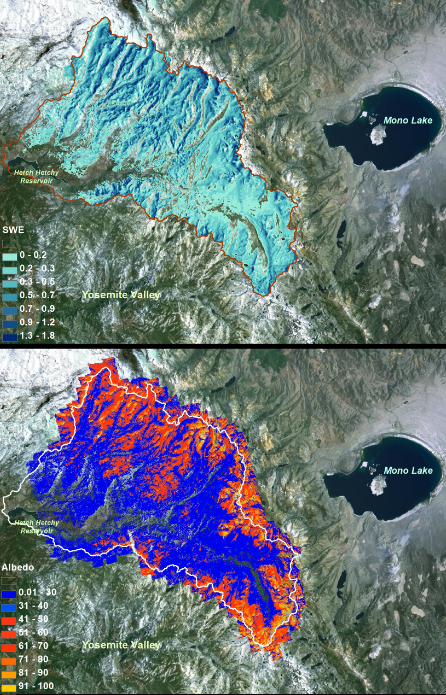
NASA has begun a new project called the “Airborne Snow Observatory” that is mounted within a Twin Otter aircraft flying at 17,500-22,000-feet over the Tuolumne River Basin in California’s Sierra Nevada as well as over Colorado’s Uncompahgre River Basin. This NASA mission will map the entire snowpack of two critical water sheds in California & Colorado mountains. The watershed in California is in Yosemite National Park and feeds into Hetch Hetchy reservoir which provides the drinking water for San Francisco. The Uncompahgre provides water for much of the American West.

The information gathered from these NASA missions will be used to estimate the amount of water that will flow out of these snowpacks when they melt down during the summer months. AND this informations will be great for skiers and riders as it will let us know when and where the snowpack is in prime shape.
“The data-gathering technology could improve water management for 1.5 billion people worldwide who rely on snowmelt for their water supply.” – NASA

AIRBORNE SNOW OBSERVATORY DETAILS:
– Twin Otters will fly at 17,500-22,000 feet over CA & CO snowpacks
– Uses LIDAR (combo of words ‘light’ & ‘radar’) technology to create snowpack depth and snow water equivalency data
– System is accurate to within 4 inches of snow depth
– System is accurate to within 5% of snow water equivalent
– Data gathered can be processed and distributed to state water managers within 24 hours
– State water managers will use data to make decision in local water districts
– Skier and snowboarders will use data to make decisions on when and where to ski and ride

Why do we want to know exactly how are snowpack in California & Colorado is doing? Because 75% of the American West’s and 30% of California’s drinking water comes from directly from snowmelt. More and more people on Earth means an ever increasing global thirstiness that has to be addressed and managed as well as robotically possible.
“Changes in [demand] and pressure on snowmelt-dependent water systems are motivating water managers, governments and others to improve understanding of snow and its melt. The western United States and other regions face significant water resource challenges because of population growth and faster melt and runoff of snowpacks caused by climate change. NASA’s Airborne Snow Observatory combines the best available technologies to provide precise, timely information for assessing snowpack volume and melt.”

Our current snowpack measuring system is based on monthly manual surveys conducted from January through April. The sample size of these manual snowpack measurements are very small, primarily occur at low to mid level elevations, and everything they can’t get to is guestimated. This manual program is inefficient as most the snowpack is tucked away at higher elevations that are difficult to reach on foot. State water managers use this patchwork of manually generated snowpack information to make major decisions that affect local water districts. This system clearly leads to errors.
The new NASA system will be considerably more accurate.
“The Airborne Snow Observatory is providing California water managers the first near-real-time, comprehensive determination of basin-wide snow water equivalent. Integrated into models, these data will enhance the state’s reservoir operations, permitting more efficient flood control, water supply management and hydroelectric power generation. The snow surveys are relatively inexpensive, help validate observatory data and provide snow density measurements that are key to reducing errors in estimating snow water equivalent.” – Frank Gehrke, mission co-investigator and chief of the California Cooperative Snow Surveys Program for the California Department of Water Resources.
NASA’a Airborne Snow Observatory is clearly a big step in the right direction for water management in the American West and it’s a pretty damn cool system. We’re very much looking forward to the data that this new system provides us. This will also be a great way for skiers and riders to know exactly where the snowpack stands on a monthly basis.
“We believe this is the future of water management in the western United States.” – Frank Gehrke
人気新品通販
ウェディングドレス 格安
In mid 70’s I took a Twin Otter flight from Aspen to Eagle/Vail.
That’s very sweet. Small planes are unreal. I’ve never been in a twin Otter. I’ve ridden in a turbine Otter in Alaska a few times. Unreal planes.
Complex but cool