One of the most potent volcanic eruptions in decades has obliterated a small, uninhabited South Pacific island known as Hunga Tonga-Hunga Ha‘apai. Damage assessments are still ongoing, but preliminary reports indicate that communities in the island nation of Tonga have taken heavy damage from volcanic ash and a tsunami caused by the eruption.
The volcano had sporadically erupted multiple times since 2009. The most recent burst of activity began in late December 2021, with intermittent ejections of ash, steam, and tephra. An unusually large blast rocked the volcano on January 13, 2022, but it was an even larger explosion on January 15 that produced an atmospheric shock wave and tsunami that traveled around the world.
Several Earth-observing satellites collected data during and after the eruption. Scientists affiliated with NASA’s Disasters program are now gathering imagery and data, and they are sharing it with colleagues around the world, including disaster response agencies.
The Advanced Baseline Imager on NOAA’s Geostationary Operational Environmental Satellite 17 (GOES-17) captured the natural-color images for the animation above between 5 and 8 p.m. local time (04:00 to 07:00 Universal Time) on January 15. (NASA builds and launches the GOES series of satellites for NOAA.) The eruption produced what volcanologists call an umbrella cloud, and crescent-shaped bow shock waves rippled through the plume as it expanded upward and outward over the South Pacific.
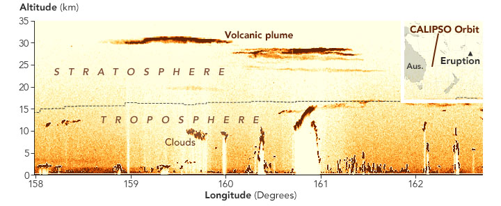
The second image, based on data collected on January 16 by the Cloud-Aerosol Lidar and Infrared Pathfinder Satellite Observation (CALIPSO) mission, shows ash and gas from the eruption rising to an altitude of 31 kilometers (19 miles). CALIPSO is a joint mission of NASA and France’s National Centre for Space Studies (CNES).
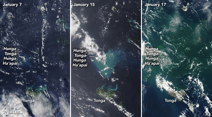
The trio of natural-color images below shows ash, pumice, and sediment discoloring the water around the eruption site. The images were acquired by the Moderate Resolution Imaging Spectroradiometer (MODIS) on NASA’s Aqua satellite.
Preliminary imagery from commercial satellites and European radar imagers suggest that very little of Hunga Tonga-Hunga Ha‘apai still stands above the waterline. The volcanic island first rose out of the water in December 2014.
This post first appeared on NASA Earth Observatory and was written by Adam Voiland.
NASA Earth Observatory images by Joshua Stevens and Lauren Dauphin, using CALIPSOdata from NASA/CNES, MODIS and VIIRS data from NASA EOSDIS LANCE and GIBS/Worldview and the Suomi National Polar-orbiting Partnership, and GOES imagery courtesy of NOAA and the National Environmental Satellite, Data, and Information Service(NESDIS).
Hopefully this causes some global cooling and some more intense winter storms similar to other historical volcanic eruptions.