A series of back-to-back atmospheric rivers has drenched much of California since late December 2022, leading to floods, debris flows, road closures, and over a billion dollars of damage.
According to the National Weather Service, almost all of the state has received rainfall totals of 400-600 percent above average between December 26, 2022, and January 9, 2023. The latest storm hit particularly hard in Southern California. Over January 8-9, 2023, much of the region from Santa Barbara to Los Angeles received 3 to 7 inches (8 to 18 cm) of rain. Ventura and Santa Barbara counties saw over 16 inches (41 cm) of rainfall in just two days.
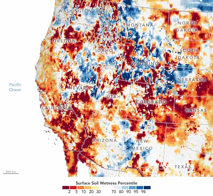
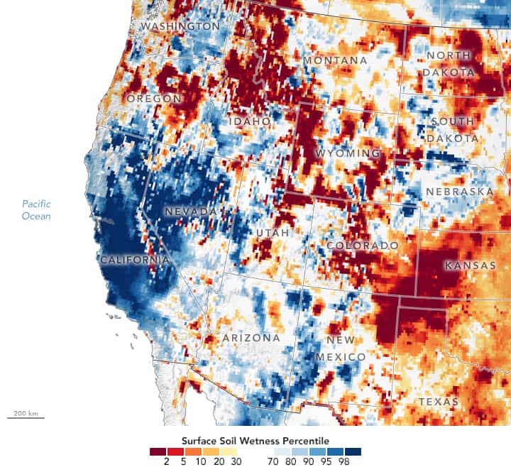
These maps show a snapshot of surface soil moisture in the western United States on December 26, 2022 (top) and January 9, 2023 (below), as measured by the Gravity Recovery and Climate Experiment Follow-On (GRACE-FO) satellites. The colors depict the wetness percentile; that is, the soil moisture on those days compared to long-term records (1948-2012) based on location and the time of year. Blue areas have more abundant water than usual, and orange and red areas have less.
Most of the state went from drier-than-normal soils on December 26, to near-record wetness levels on January 9. The vast expanse of wetter-than-usual (dark blue) soils on January 9 created hazardous conditions throughout the state as the rain continued to fall.
On January 9, evacuation orders were in place for 25,000 people near Santa Barbara, including the entire community of Montecito, due to heightened flood and mudslide risks. In the Santa Ynez Mountains above Santa Barbara, mud and debris blocked a roadway and isolated hundreds of people. About 20 miles east of Montecito, a mudflow blocked another road near Casitas Springs.
The unrelenting atmospheric rivers come after drought has plagued the state since 2020. According to a recent report from NOAA’s National Centers for Environmental Information, 2022 was the ninth-driest year in California on a record that goes back to 1895.
As of January 3, virtually all of California was still in a moderate or severe drought, according to the U.S. Drought Monitor. But the latest rain and snow swamping the state could help. A recent snow survey found that the Central and Southern Sierra have twice as much snow as is normally seen this time of year. And water levels in California’s reservoirs are rising quickly. However, some of the state’s largest reservoirs, such as Lake Shasta and Lake Oroville, are still below-average levels.
Yet another atmospheric river is headed toward the U.S. West Coast on January 11. This time, the storm is expected to impact areas farther north—from Northern California and up the coast of the Pacific Northwest.
This post first appeared on NASA Earth Observatory. NASA Earth Observatory images by Lauren Dauphin, using GRACE data from the National Drought Mitigation Center. Story by Emily Cassidy.