NOAA has issued a Winter Storm Watch for Lake Tahoe, CA/NV from Monday morning until Wednesday morning.
This watch forecasts 1-3 feet of snow with big winds.
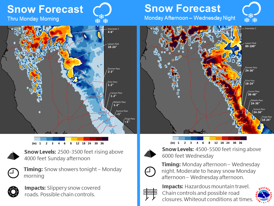
The above infographic by NOAA talks of 24-36″ of snow for Donner Pass and 98-124″ of snow for Mt. Lassen National Park, CA!
* WHAT...Heavy snow possible. Total snow accumulations of 10 to 20 inches,
except 1 to 3 feet above 7000 feet possible. Winds could gust as high as
55 mph. Ridge gusts could exceed 100 mph.
- NOAA Reno, NV today
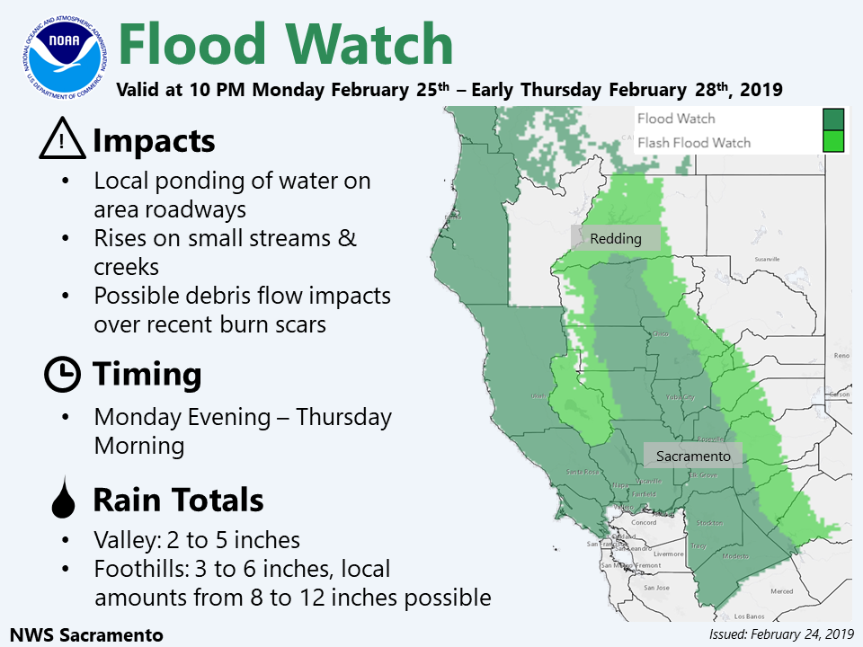
This storm might get really crazy considering that NOAA has issued flood watches for the western valleys and is calling for 8-12 inches of rain down there in spots!
This storm will be warmer than the latest cold storm in Tahoe with snow levels rising as high as 6,000+ feet at times.
Tahoe is on track for a top 3 best snowfall seasons in recorded history with 515″ having already fallen on Squaw Valley.
Squaw Valley averages 450″ of snowfall per year meaning that we are already 65″ past our annual snowfall and it’s not even March yet…
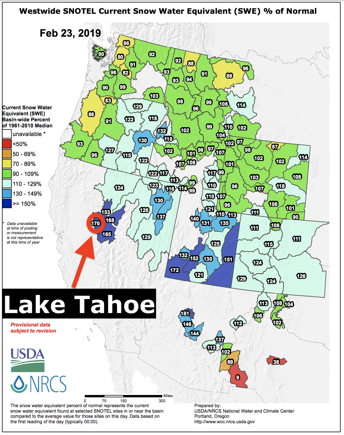
The Lake Tahoe snowpack is currently sitting at 172% of average to date and is the 2nd deepest in the nation (only Mammoth is deeper).
Squaw Valley has already seen its largest February snowfall total in history with 254″ having already fallen in February and much more on the way before the month is over.
Lake Tahoe even rose 12″ since February which is about 40 billion gallons of water.
This is the year to be in Tahoe…

Winter Storm Watch for Lake Tahoe
URGENT - WINTER WEATHER MESSAGE
National Weather Service Reno NV
322 AM PST Sun Feb 24 2019

Greater Lake Tahoe Area-
Including the cities of South Lake Tahoe, Truckee, Stateline,
and Incline Village
322 AM PST Sun Feb 24 2019

...WINTER STORM WATCH IN EFFECT FROM MONDAY MORNING THROUGH
WEDNESDAY MORNING...

* WHAT...Heavy snow possible. Total snow accumulations of 10 to 20
  inches, except 1 to 3 feet above 7000 feet possible. Winds could
  gust as high as 55 mph. Ridge gusts could exceed 100 mph.

* WHERE...Greater Lake Tahoe Area.

* WHEN...From Monday morning through Wednesday morning. Heaviest
  snow possible late Monday night and early Tuesday

* ADDITIONAL DETAILS...Travel could be very difficult to
  impossible. Very strong winds could cause extensive tree
  damage.