NOAA: 17-23 Inches of Liquid Precipitation Forecast for Washington Next 7 Days

WeatherBrains | | Post Tag for WeatherWeather
NOAA's 7-day liquid precipitation forecast showing 15-23" of liquid precip heading to Washington.
NOAA’s 7-day liquid precipitation forecast showing 15-23″ of liquid precip heading to Washington.

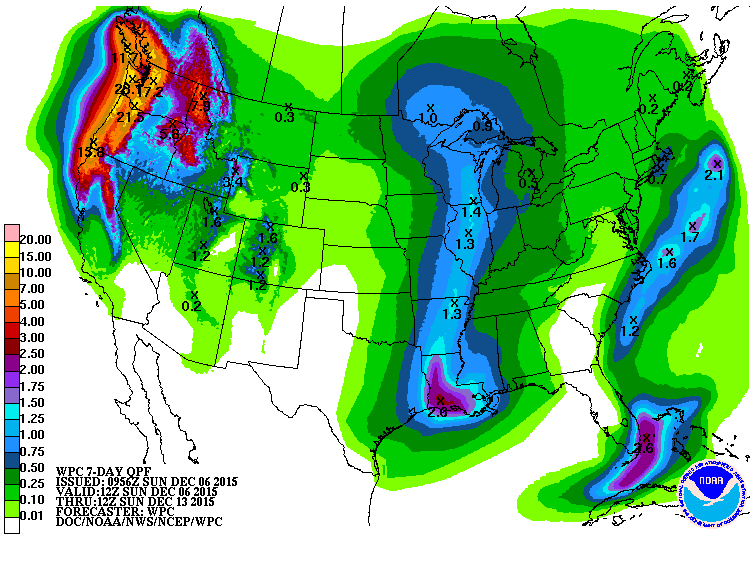
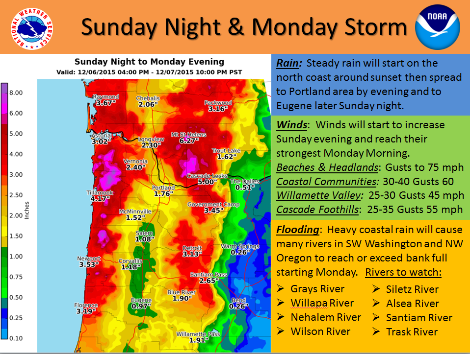
NOAA is forecasting an insane amount of precipitation for Washington in the next week.

17-23 inches of liquid precipitation if forecast to fall on Washington in the next 7 days.  If that all came as snow, that would translate to 15-23 feet of snow.

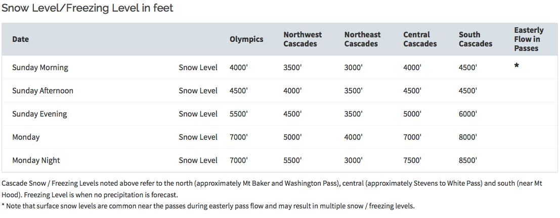
Snow levels will be fluctuating with these storms.  Snow levels are forecast to get higher with each successive storm this week until topping out around 8,000-feet Tuesday.  Snow levels are forecast to drop back down to 2,000-3,500 feet on Wednesday and remain there while 2 or 3 storms roll through Wed – Sat (see graphs & info below).  Mt. Baker ski area lives between 3,000 and 5,000 feet.  Crystal Mountain ski area lives between 4,400 and 7,000 feet.

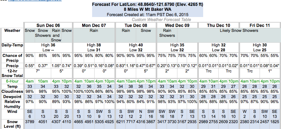
The upper mountain of 10-781′ Mt. Baker is forecast to see 88-119″ of snow in the next 3 days.

Screen Shot 2015-12-06 at 11.28.49 AM

NOAA's forecast for 10,781' Mt. Baker proper is forecasting 88-119" (t0-feet) of snow in the next 3 days. image: noaa, today
NOAA’s forecast for 10,781′ Mt. Baker proper is forecasting 88-119″ (t0-feet) of snow in the next 3 days. image: noaa, today
Mt. Washington ski resort, Vancouver Island, Canada (across the straights from Washington) today...
Mt. Washington ski resort, Vancouver Island, Canada (across the straights from Washington) today…

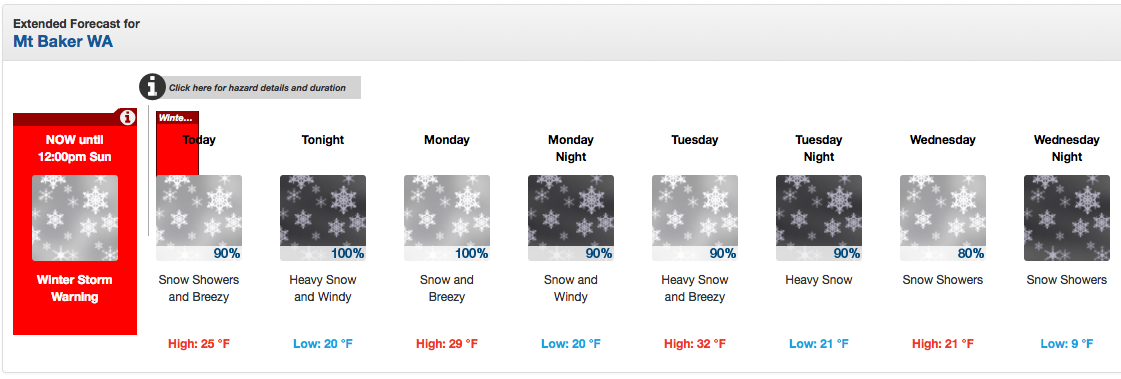
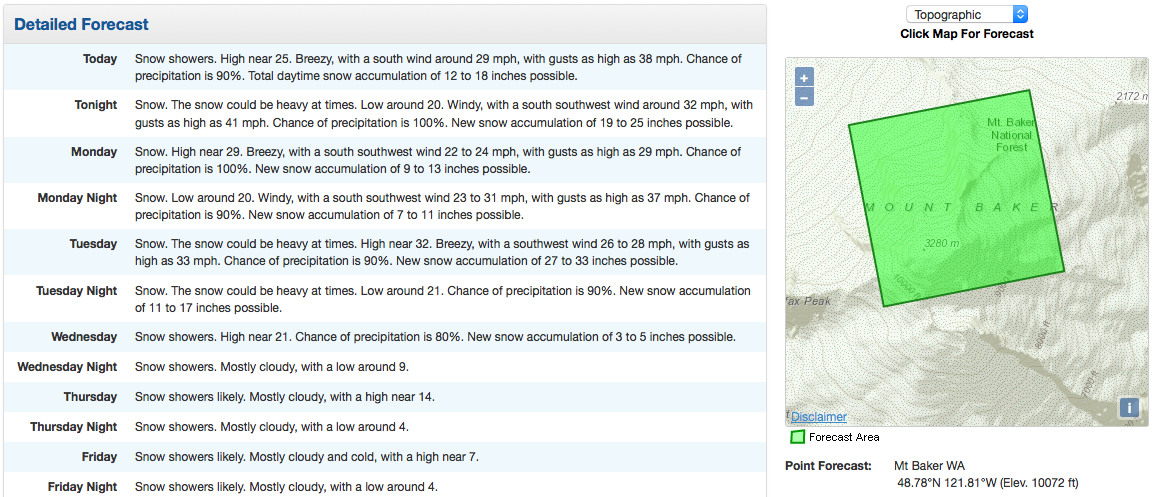
Snow levels are forecast to get higher with each successive system until Tuesday.  On Wednesday snow levels are forecast to drop back down to the 2,000-3,500 foot range while 2 or 3 storms roll through Washington Wednesday to Saturady.

SNOW LEVELS - EACH INCOMING SYSTEM BRINGS YET WARMER AIR. FLOW IN
THE PASSES TO BRIEFLY GO WEST AND MODERATE TEMPS THERE TODAY BEFORE
SWINGING BACK TO EAST LATE TODAY. YET THE TREND IS FOR HIGHER SNOW
LEVELS WITH EACH SYSTEM INTO TUESDAY...CLIMBING FROM 4000 TO 5000 FT
TODAY TO 5000 TO 7000 FT MONDAY AND PERHAPS AS HIGH AS 8000 FT
TUESDAY. - NOAA Seattle, WA today

.LONG TERM...FROM THE PREVIOUS DISCUSSION...IT LOOKS LIKE THERE WILL
BE A TRANSITION TO A COOLER PATTERN AROUND WEDNESDAY OR WEDNESDAY
NIGHT...BUT RECENT MODEL RUNS OF THE GFS...EUROPEAN...AND CANADIAN
MODELS KEEP THE PATTERN FAIRLY ACTIVE WITH TWO OR THREE SYSTEMS
MOVING THROUGH BETWEEN WEDNESDAY AND SATURDAY. THERE IS A GOOD
CHANCE THE SNOW LEVEL WILL BE MAINLY IN THE 2000 TO 3500 FT RANGE
DURING THIS PERIOD. - NOAA Seattle, WA today
NWAC's snow level forecast next 4 days for Washington. image: nwac, today
NWAC’s snow level forecast next 4 days for Washington. image: nwac, today
NOAA's snow level forecast for Mt. Baker ski area next 5 days
NOAA’s snow level forecast for Mt. Baker ski area next 5 days
72-hour snow probabilities are high for Washington. image: noaa, today
72-hour snow probabilities are high for Washington, Dec. 6-9. image: noaa, today
"Yet another frontal system is approaching the Oregon and Washington coast. This storm will produce widespread heavy rain starting on the coast Sunday afternoon and spreading inland by evening. Rainfall in coastal areas could reach 5 to 8 inches in just 24 hours." - NOAA Portland, OR today
“Yet another frontal system is approaching the Oregon and Washington coast. This storm will produce widespread heavy rain starting on the coast Sunday afternoon and spreading inland by evening. Rainfall in coastal areas could reach 5 to 8 inches in just 24 hours.” – NOAA Portland, OR today

***

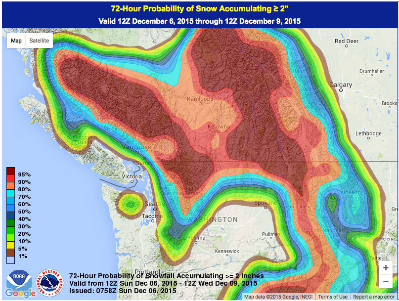
NOAA’s long term forecast maps are showing “Heavy Precipitation” the next 3-14 days.

***

NOAA's 3-7 day forecast showing "Heavy Precipitation" in Tahoe.
NOAA’s 3-7 day forecast showing “Heavy Precipitation” in Washington on Dec 7th-11th.
hazards_d8_14_contours
NOAA’s 8-14 day forecast showing “Heavy Precipitation” in Washington on Dec 12th.

Related Articles

Got an opinion? Let us know...