Earlier this week the NOAA released an updated outlook for the beginning of winter, and what weather that might bring.
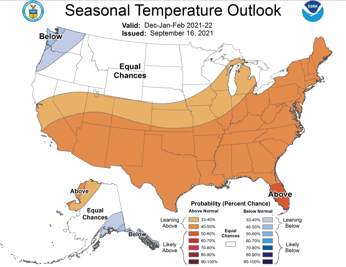
It’s looking good for the PNW, where cooler and wetter than normal conditions are forecast. In California, the exact opposite is predicted, the start to winter there will be warmer and drier than normal.
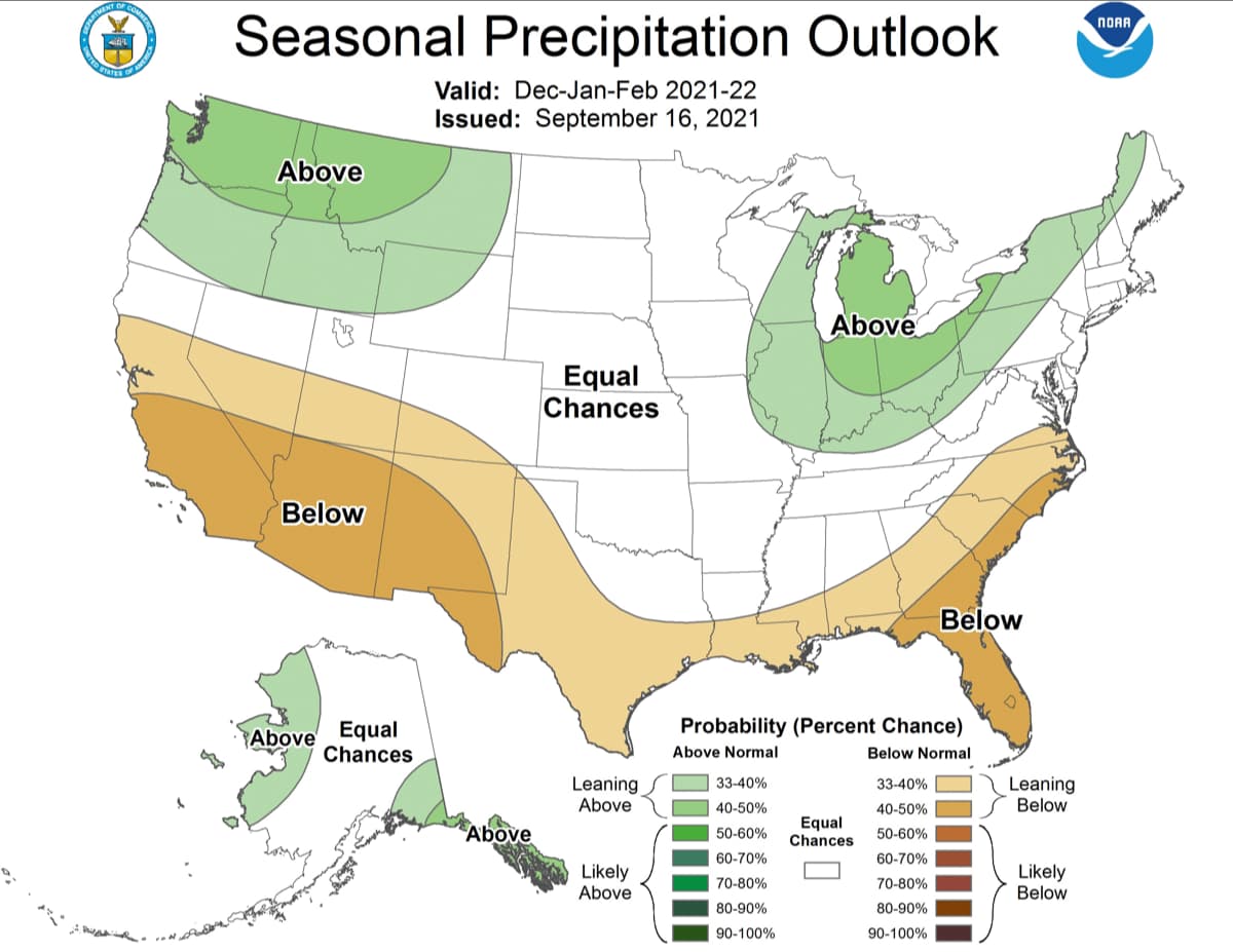
Wyoming, Montana, and Idaho can expect normal temperatures, and above-normal precipitation might bring some decent early season snow. Colorado and Utah can expect to be warmer than normal, and drier than normal in the southern parts of those states.
The full forecast discussion from the NOAA is below:
TEMPERATURE
Above normal temperatures are favored throughout a majority of the southern and eastern CONUS and western Alaska during OND. Conversely, below normal temperatures are more likely for southeastern Alaska. Equal chances (EC) of below, near, or above normal temperatures are forecast for the northwestern and north-central CONUS. This EC area is due to weak or conflicting signals among temperature tools. Probabilities of above normal temperatures are increased relative to last month across the East due to stronger support among the temperature guidance. Above normal temperatures are especially likely (greater than 50 percent) for eastern New England due to good agreement among both dynamical and statistical guidance. Guidance has trended colder across much of Alaska relative to last month. Thus, increased probabilities of below normal temperatures were introduced to southeastern parts of the state, which is also consistent with composites from the current ENSO state.
From NDJ through FMA, impacts from the potential La Niña become more apparent as above normal temperatures continue to be favored across the Southern CONUS and the Eastern Seaboard while enhanced below normal temperature probabilities persist across southeastern Alaska and expand southward to the northwestern CONUS. Thereafter, the forecast pattern increasingly begins to reflect trends with above normal temperatures generally favored across most of the southern, western, and eastern CONUS next spring, summer, and into the fall. Probabilities of above normal temperatures peak across the West next summer and across the Eastern Seaboard next fall, consistent with trends. Across Alaska, above normal temperatures become increasingly likely with time, with the strongest warm signal emerging next summer, when probabilities of above normal temperatures exceed 50 percent for most of the state.
PRECIPITATION
Model guidance remains consistent from previous months depicting elevated probabilities of below normal precipitation for much of the southern and central CONUS, and increased chances of above normal precipitation for the Pacific Northwest during OND. Models are consistent in depicting an expansion of a dry signal eastward across the Southeast, with influences from potential tropical disturbances decreasing and La Niña influences increasing as we progress deeper into the fall and early winter. Conversely, precipitation guidance has trended wetter across the northwestern CONUS, resulting in an increase in above normal precipitation probabilities relative to last month. Additionally, an area of slightly increased probabilities of above normal precipitation was introduced to the Great Lakes region and interior Northeast, consistent with the latest C3S guidance. A slight tilt toward above normal precipitation is also indicated for parts of southwestern Alaska, based primarily on dynamical model guidance. EC is indicated for the rest of the forecast domain as signals for the various dynamical and statistical tools are too weak or conflicting to issue a forecast with a sufficient degree of confidence.
As we progress further into late fall and through the winter, dynamical and statistical guidance persist with a dry signal across the southern CONUS, consistent with a La Niña signature. An eastward expansion of enhanced above normal precipitation probabilities is noted across the northwestern CONUS, as well as a northward expansion across the Alaska Panhandle, peaking in coverage during the winter. A wet signal is also favored to expand southward from the Great Lakes to the Ohio Valley during the winter with the strongest signal evident during JFM, consistent with La Niña composites. During next spring through next fall, trends become the dominant factor with increased chances of above normal precipitation generally indicated across parts of the Eastern CONUS and Gulf Coast Region through much of the period. Conversely, trends favor a dry pattern for much of the West next spring and summer, with increased chances of dryness for parts of the Northern Plains next summer as well. Thereafter, an area of slightly enhanced probabilities of above normal precipitation makes a brief appearance across the Pacific Northwest in ASO, based primarily on statistical guidance from trends and ENSO. A tilt toward a dry pattern persists farther to the south across parts of the remainder of the West into next fall, based primarily on trends. There exists high uncertainty across much of Alaska through the period with large areas of EC indicated. However, dynamical guidance supports increased odds of above normal precipitation across parts of the western and northern Mainland through the MAM season. Conversely, statistical guidance from trends and ENSO support a slight tilt toward below normal precipitation for parts of the South Coast early in the spring shifting toward the southwestern Mainland later in the spring. Thereafter, trends support slightly increased chances for above normal precipitation for parts of the eastern Mainland next summer and slightly increased chances of below normal precipitation for parts of the Panhandle next fall.