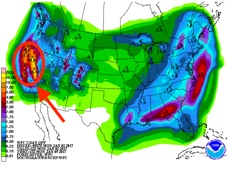
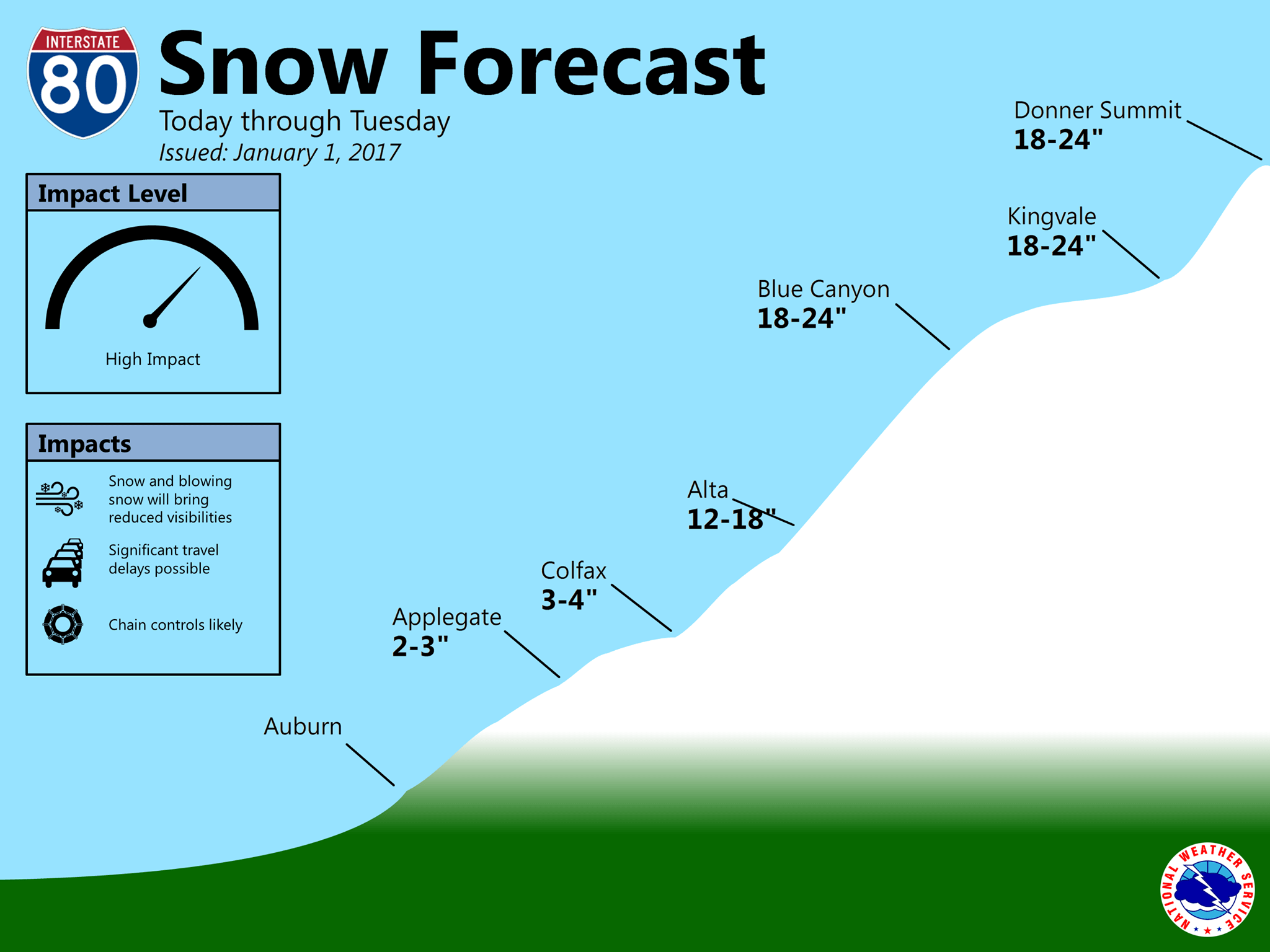
NOAA has issued Winter Weather Advisories and Winter Storm Warnings for Lake Tahoe, CA/NV today that are calling for 34-56″ of snow to fall between today and Wednesday.
* SNOW ACCUMULATIONS THROUGH TUESDAY MORNING: 5 TO 10 INCHES, WITH
  10 TO 20 INCHES WEST OF HIGHWAY 89 TO THE SIERRA CREST. 1O TO 15
  INCHES IN THE NORTHERN CARSON RANGE NEAR MOUNT ROSE.

* SNOW ACCUMULATIONS TUESDAY AFTERNOON THROUGH WEDNESDAY NIGHT: 12
  TO 18 INCHES AT LAKE LEVEL WITH UP TO 2 TO 3 FEET ABOVE 7000
  FEET.
- NOAA Reno, NV today
NOAA has also issued a Special Weather Statement that is calling of 2-3″ per hour snowfall rates due to lake effect snow on the east side of Lake Tahoe (Carson Range) today.
As of right now, it looks like Tahoe is going to be getting blasted by snow the next 10 days.

Squaw Valley is already reporting 8″ of snow this morning and it’s currently snowing lightly at the house in Squaw.
Winds are strong today 43-74mph at the top of Squaw right now (as high as 101mph last night) so most of the upper mountains of Tahoe will most likely be closed today.

Winter Storm Warning
URGENT - WINTER WEATHER MESSAGE
NATIONAL WEATHER SERVICE RENO NV
624 AM PST MON JAN 2 2017

GREATER LAKE TAHOE AREA-
INCLUDING THE CITIES OF SOUTH LAKE TAHOE, TRUCKEE, STATELINE,
AND INCLINE VILLAGE
624 AM PST MON JAN 2 2017

...WINTER WEATHER ADVISORY REMAINS IN EFFECT UNTIL 10 AM PST
TUESDAY...
...WINTER STORM WARNING IN EFFECT FROM 10 AM TUESDAY TO 4 AM PST
THURSDAY...

THE NATIONAL WEATHER SERVICE IN RENO HAS ISSUED A WINTER STORM
WARNING FOR HEAVY SNOW, WHICH IS IN EFFECT FROM 10 AM TUESDAY TO
4 AM PST THURSDAY.

* TIMING: WIDESPREAD SNOW SHOWERS WILL CONTINUE TODAY INTO TUESDAY
  MORNING. SNOW WILL BECOME HEAVY AT TIMES TUESDAY AFTERNOON
  THROUGH WEDNESDAY NIGHT.

* SNOW ACCUMULATIONS THROUGH TUESDAY MORNING: 5 TO 10 INCHES, WITH
  10 TO 20 INCHES WEST OF HIGHWAY 89 TO THE SIERRA CREST. 1O TO 15
  INCHES IN THE NORTHERN CARSON RANGE NEAR MOUNT ROSE.

* SNOW ACCUMULATIONS TUESDAY AFTERNOON THROUGH WEDNESDAY NIGHT: 12
  TO 18 INCHES AT LAKE LEVEL WITH UP TO 2 TO 3 FEET ABOVE 7000
  FEET.

* WINDS: WIND GUSTS UP TO 40 MPH MAY RESULT IN AREAS OF BLOWING
  SNOW WITH REDUCED VISIBILITY AND PERIODS OF WHITEOUT
  CONDITIONS. WINDS WILL BE OVER 60 MPH FOR EXPOSED RIDGES.

* LAKE TAHOE: WIND GUSTS 35 TO 45 MPH TODAY. WAVE HEIGHTS OF 2 TO
  4 FEET WITH HIGHEST WAVES FROM MID LAKE TO EASTERN SHORES.

* IMPACTS: SNOW WILL CAUSE SLICK SNOW COVERED ROADS WITH CHAIN
  OR SNOW TIRE RESTRICTIONS EXPECTED. GUSTY WINDS COULD CAUSE
  AREAS OF LOW VISIBILITY DUE TO BLOWING SNOW WITH NEAR
  WHITEOUT CONDITIONS AT TIMES.

PRECAUTIONARY/PREPAREDNESS ACTIONS...

TRAVEL IS DANGEROUS! CARRY TIRE CHAINS, FLASHLIGHT, EXTRA FOOD,
WATER AND CLOTHING IN YOUR CAR IN CASE YOU GET STUCK. LET A FRIEND
OR RELATIVE KNOW YOUR TRAVEL PLANS, ESPECIALLY IF YOU ARE HEADING
INTO THE BACK COUNTRY.
Special Weather Statement
Special Weather Statement
National Weather Service RENO NV
707 AM PST Mon Jan 2 2017

Greater Lake Tahoe Area-Greater Reno-Carson City-Minden Area-
Including the cities of South Lake Tahoe, Tahoe City, Truckee,
Markleeville, Stateline, Glenbrook, Incline Village, Sparks,
Verdi, Gardnerville, and Virginia City

...LAKE EFFECT SNOWBAND DEVELOPING EAST OF TAHOE...

A potent lake effect snowfall band has developed across Lake Tahoe
and extends along Highway 50 through the Carson Range, Carson
City and as far east Dayton and Virgina City.

Lake effect snowbands can produce heavy snowfall rates of 2-3" an
hour. This combined with gusty winds up to 40-45 mph can produce
sudden whiteout conditions with near zero visibility in blowing
snow.

This band will impact Highway 50 through Spooner Summit, Highway
395 from Carson City into Washoe Valley, and Highway 50 east of
Carson City to near the Dayton area. Hazardous travel can be
expected throughout the morning in these areas. Slow down and give
yourself extra time to reach your destination if you have to
travel through these areas.
Gorgeous snowfall in Zephyr Cove.. it has been steadily falling all day.. woke to about 5 inches..
#WayOverStoking – Let’s wait watch and see… Last three reports like this turned out to be 5″ to 7″ of rain and 12″ of snow…
Stay’nThirsty,
Coop
So far so good! Today was unreal at Alpine Meadows. 12-18″ of new snow by 4pm and still nuking snow right now. How was Kirkwood today, Coop? Deep I bet! 🙂