NOAA has issued a Winter Weather Advisory today for Colorado’s mountains today that is calling for 5-14″ of snow today with snowfall rates up to 1″ per hour at times. Things will dry out on Sunday before the next storm rolls in on Tuesday-Wednesday.
“A dry day is expected on Sunday with the next storm system impacting the area Tuesday through Wednesday.” – NOAA Grand Junction, CO today
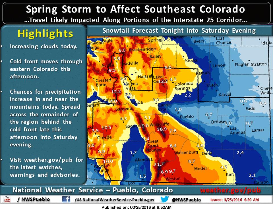
The graphic below is showing up to 21″ of snowfall forecast in spots.
“Snowfall rates up to one inch per hour will be possible.” – NOAA Denver, CO today
Colorado ski resorts just saw up to 24″ of snowfall in the past 3-days. Another 5-14″ of snow in CO today is gonna make for a killer weekend.
3-Day Snowfall Totals at CO Ski Resorts:
Steamboat = 24″
Telluride = 22″
Winter Park = 19″
Beaver Creek = 18″
Vail = 18″
Powderhorn = 17″
Breckenridge = 17″
Loveland = 15″
Silverton = 14″
Monarch = 12″
Keystone = 12″
Aspen = 12″
Copper = 12″
Eldora = 11″
image: noaa, today
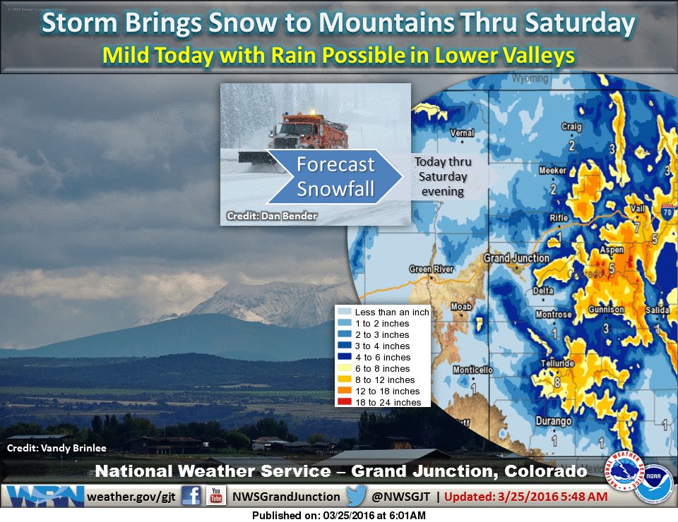
“Snow will begin over the northern and central mountains this morning before shifting to the central and southern mountains this evening into Saturday afternoon, as a low pressure system and associated cold front move through the area from north to south tonight. The lower valleys will see relatively mild conditions today with chances of rain increasing this evening as the cold front and low track south of I-70. Rain may mix in at times with snow and while the higher valleys will see some snowfall, impacts appear to be minimal. The mountains however will benefit the most from this storm with snowfall amounts in the 5 to 10 inch range with some higher amounts of 8 to 14 inches in the northern Colorado mountains. Showers will wind down Saturday evening and come to an end Saturday night as drier air moves in behind this system. A dry day is expected on Sunday with the next storm system impacting the area Tuesday through Wednesday. Temperatures will be cooler in clouds and showers.” – Grand Junction, CO
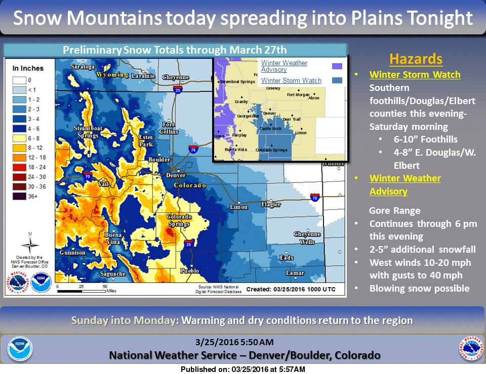
image: noaa, today“A Winter Storm Watch has been issued for the southern foothills as well as portions of Douglas and Elbert counties from this evening through Saturday afternoon. For the foothills 6-10 inches of snow will be possible with 4-8 inches possible over eastern Douglas and Western Elbert Counties. The Winter Weather Advisory continues for the Gore Range through 6 pm this evening. Warm up coming Sunday into Monday.” – NOAA Denver, CO today
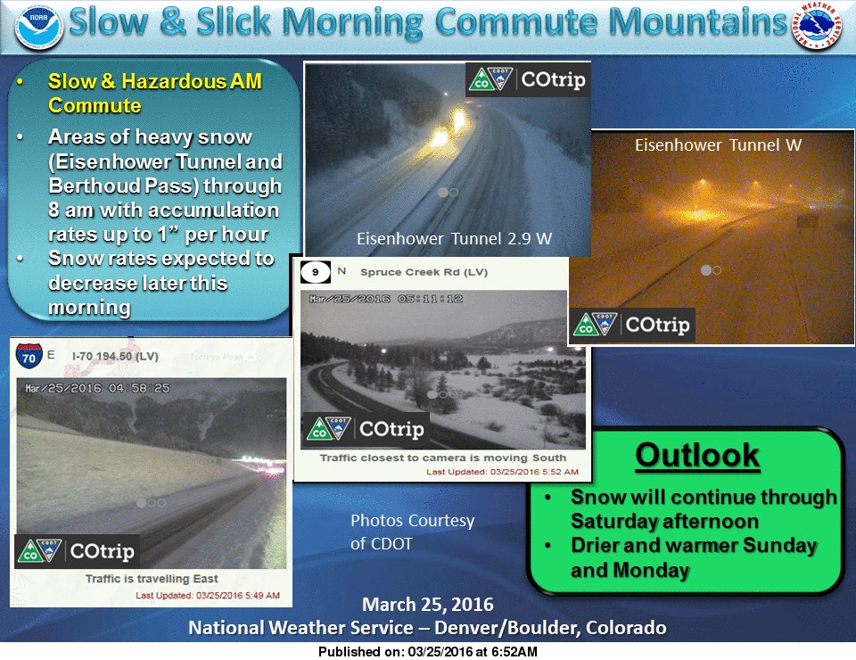
“Areas of heavy snow will continue in the mountains through 8 am…especially across Berthoud and Loveland Passes. Snowfall rates up to one inch per hour will be possible. Watch out for hazardous driving conditions.” – NOAA Denver, CO today
WINTER WEATHER ADVISORY for COLORADO:
URGENT - WINTER WEATHER MESSAGE
NATIONAL WEATHER SERVICE GRAND JUNCTION CO
432 AM MDT FRI MAR 25 2016

GORE AND ELK MOUNTAINS/CENTRAL MOUNTAIN VALLEYS-

...WINTER WEATHER ADVISORY REMAINS IN EFFECT UNTIL MIDNIGHT MDT
TONIGHT...

* LOCATIONS INCLUDE THE CITIES OF...ASPEN...VAIL...SNOWMASS.

* TIMING...SNOW WILL INCREASE LATE TONIGHT AND CONTINUE THROUGH
  FRIDAY NIGHT.

* SNOW ACCUMULATION...5 TO 10 INCHES WITH LOCALLY HIGHER AMOUNTS
  ON WEST AND NORTHWEST FACING SLOPES.

* WINDS...WEST 10 TO 20 MPH WITH GUSTS UP TO 30 MPH.

* IMPACTS...ROADS WILL BE ICY AND SNOWPACKED.