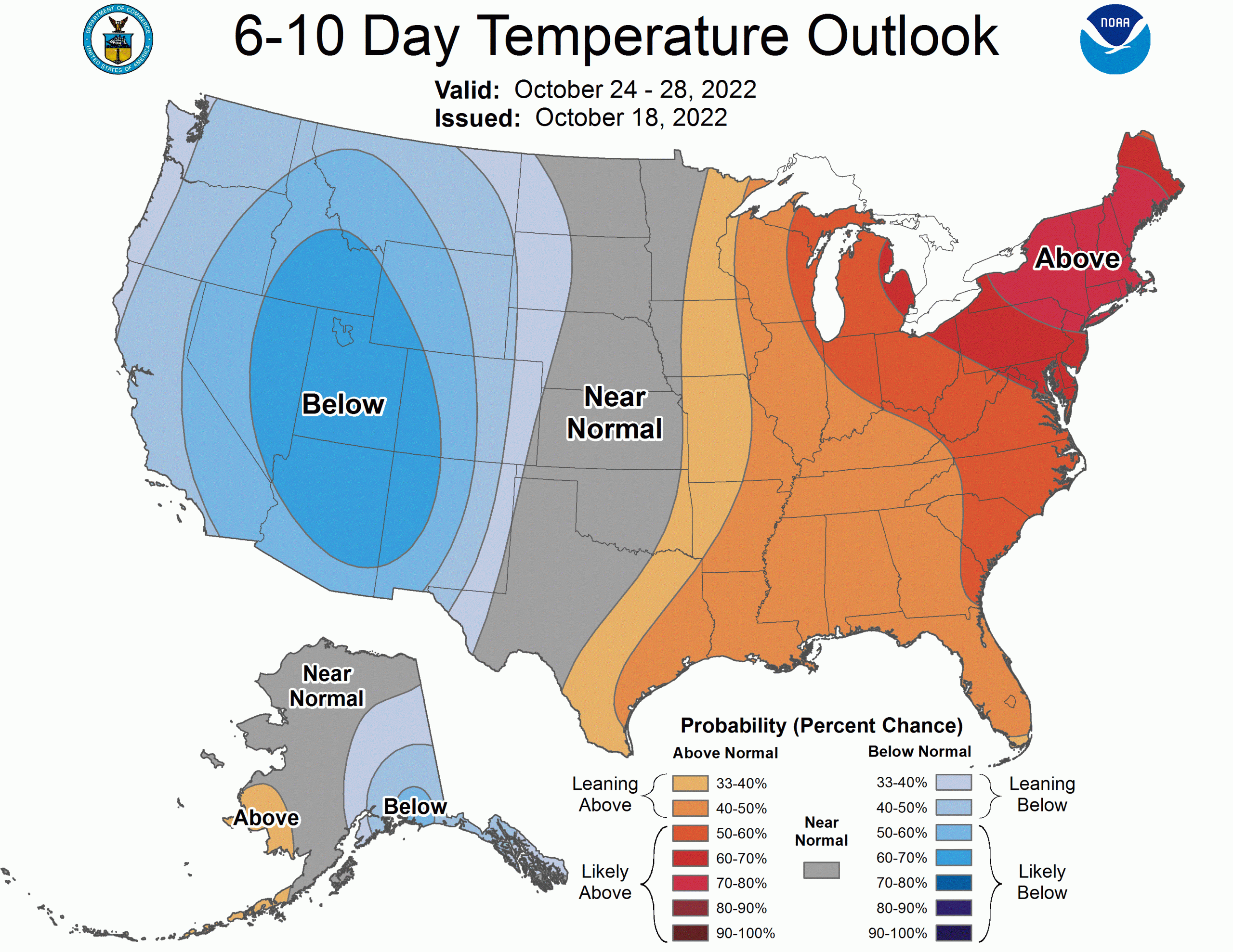
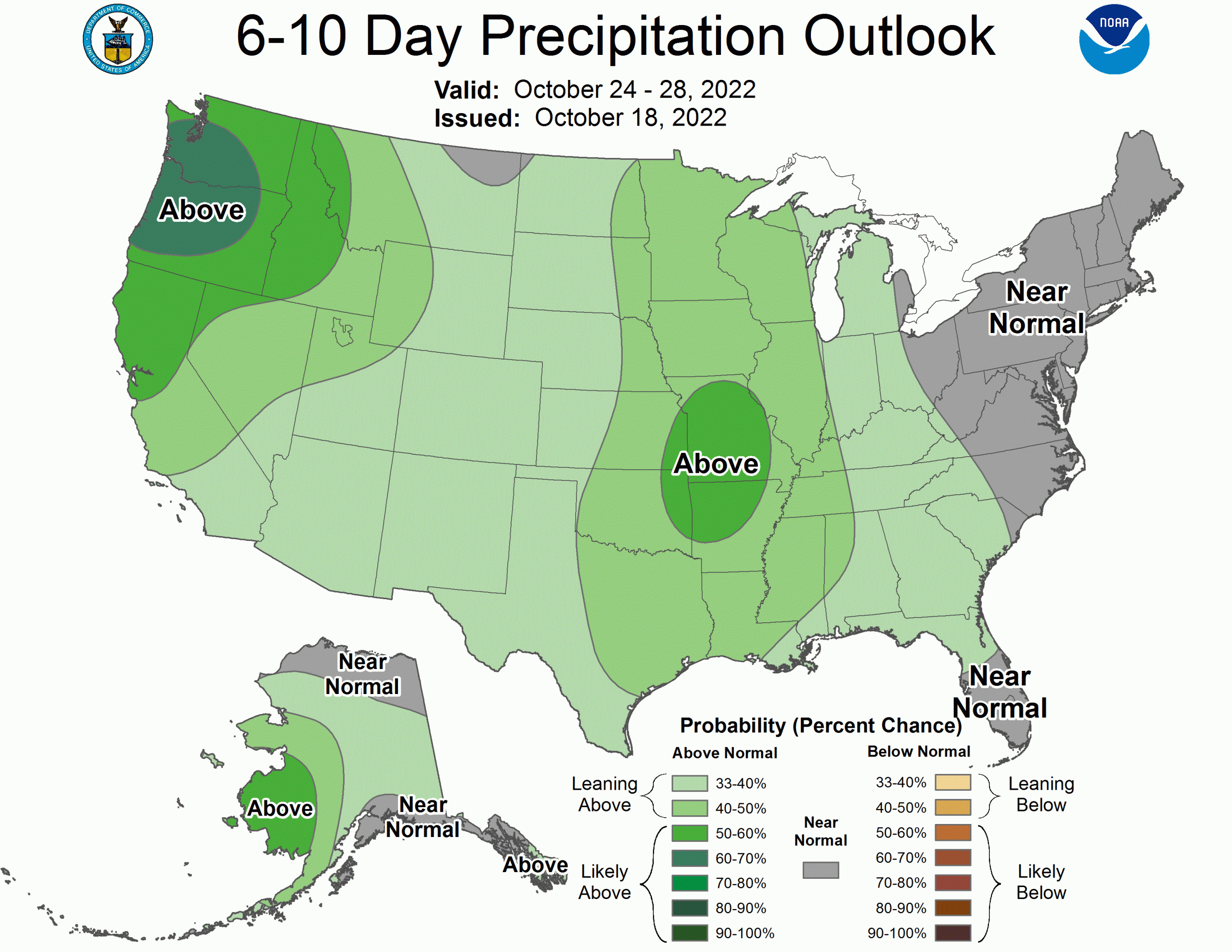
6-10 Day Outlook:
Below-average temperatures are expected for the Western United States with above-average precipitation for the Western and Central US. Snowfall is expected to impact much of the Pacific Northwest and parts of the Rocky Mountains by the end of the weekend into next week.
- Related: SnowBrains Forecast: First Taste of Winter for the Cascades | 3-10″ This Weekend, More Coming
8-14 Day Outlook:
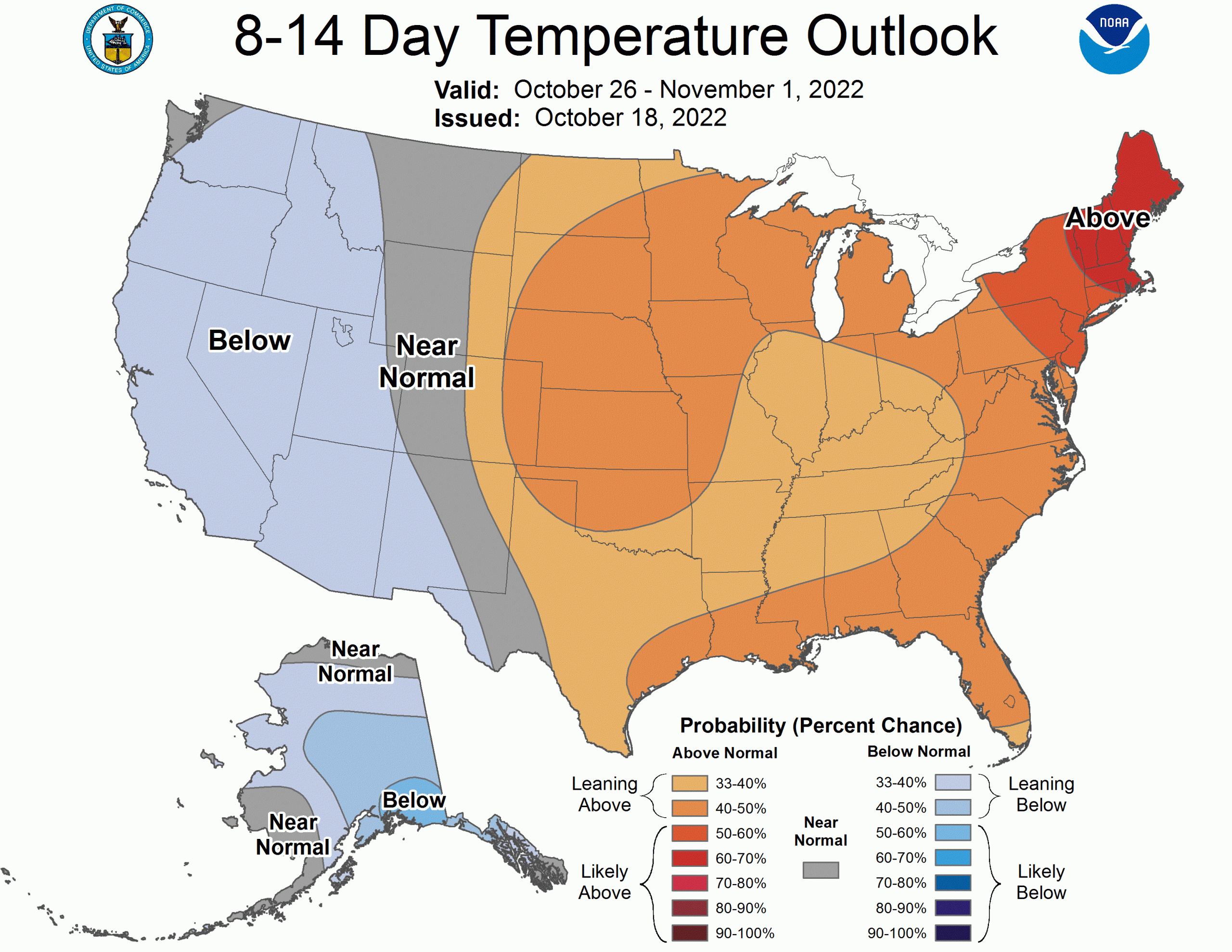
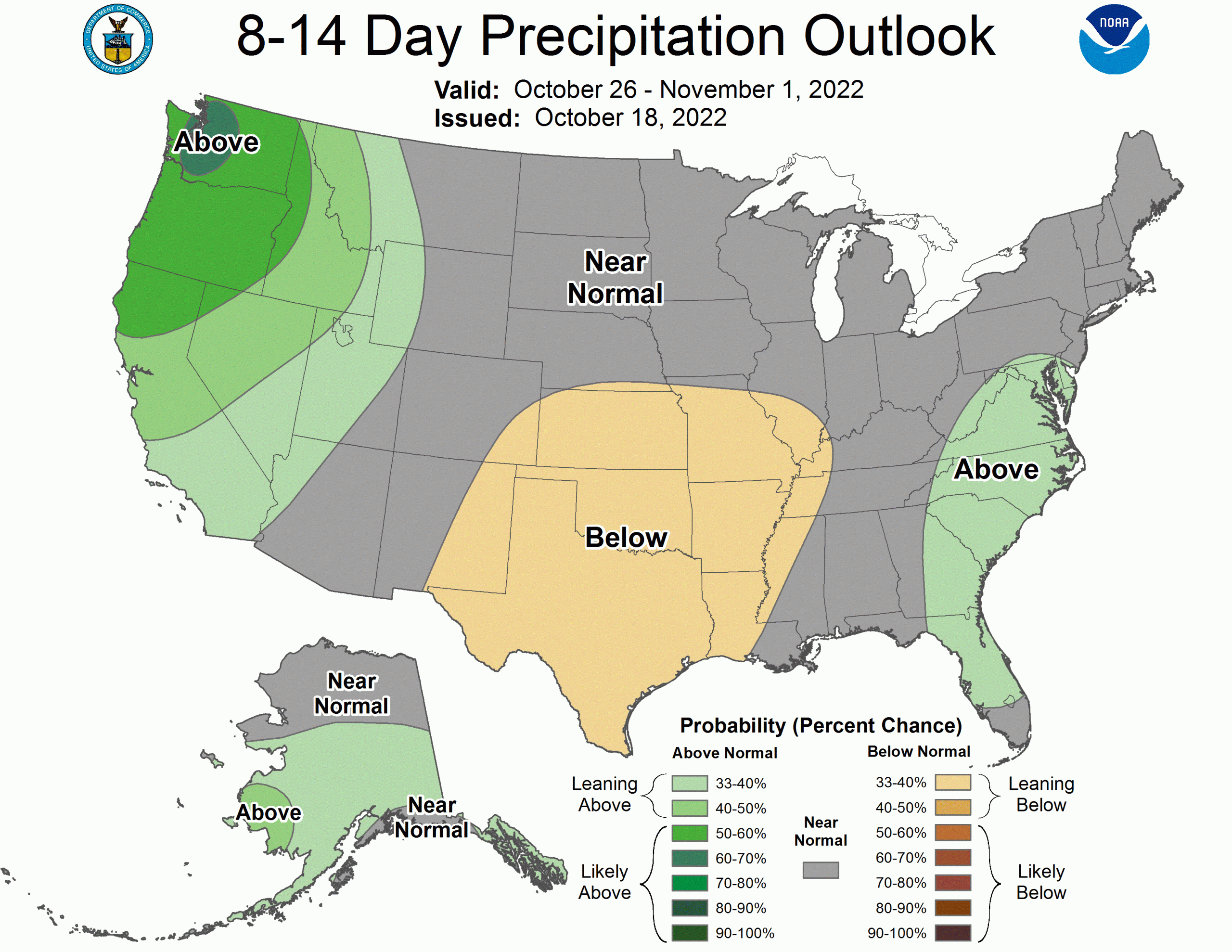
Below-average temperatures are expected to persist in the Western United States with above-average precipitation for the next 8-14 days. The Central and Eastern US are expecting near-normal to above-average temperatures and generally normal levels of precipitation. Parts of Alaska are expecting below-average temperatures and above-average precipitation during this period.
Full discussions from NOAA below:
6-10 DAY OUTLOOK FOR OCT 24 - 28 2022

There is good agreement in the predicted mean 500-hPa heights among the
dynamical models during the 6-10 day period. Dynamic ensemble models agree on
an amplified pattern across the forecast domain with strong positive 500-hPa
height anomalies over eastern North America and the North Pacific south of the
Aleutian Islands and anomalous troughing over western North America, eastern
Siberia, and south of Greenland. Relative to yesterday, the negative 500-hPa
height anomalies are weaker across the west. However, these changes do not
substantially alter the forecast.

The amplified mean mid-level ridge over eastern North America leads to
increased chances for above-normal temperatures across most of the eastern
Continental United States (CONUS). The highest probabilities are in the
Northeast where positive 500-hPa height anomalies are the greatest. A strong
cold front is favored to develop across the center of the country. This is
likely to be a focus for precipitation and reduces confidence in the
above-normal temperature chances. Thus, probabilities for above-normal
temperatures are reduced across parts of the Great Plains and Midwest. Across
the West, negative 500-hPa height anomalies lead to good agreement for
below-normal temperatures across the region. With slightly weaker negative
500-hPa height anomalies across the West, cold chances are slightly reduced
relative to yesterday. Likewise, the eastward extent of enhanced below-normal
odds is also reduced but is maintained through the Front Range of the Rocky
Mountains and much of the High Plains. In Alaska, there is fair agreement among
the temperature tools for below-normal temperature chances across much of the
state. However, the Aleatians and Alaska Peninsula are favored to have
above-normal temperatures closer to the mid-level ridge in the North Pacific.

The amplified mid-level trough across the west ushers in enhanced probabilities
for above-normal precipitation across the western CONUS. Reforecast tools are
in good agreement for enhanced probabilities for above-normal precipitation
across the Pacific Northwest. There is disagreement on how far south the
enhanced chances for above-normal precipitation should extend along the Pacific
coast. The ECMWF reforecast tools bring high probabilities down towards the Bay
Area of California while the GEFS-based tools keep these elevated chances
closer to the California-Oregon border. Likewise, analog tools favor dryer
conditions in California. Therefore, strongest chances for above-normal
precipitation are confined to Washington and Oregon with relatively lower
chances for above-normal precipitation in Northern California. Across the
center of the country, near the boundary between positive and negative 500-hPa
height anomalies, chances for above-normal precipitation remain enhanced.
Deterministic and ensemble model runs indicate chances for lee side
cyclogenesis off the Rocky Mountains. Along with cyclogenesis, return flow from
the Gulf of Mexico is also expected near and along the Mississippi Valley
bringing higher chances for above-normal precipitation to these regions. Along
the Atlantic Coast, tools are mixed for above or below-normal precipitation
among models and between model runs. Therefore, much of the East Coast is
favored for near-normal precipitation. In Alaska, ensemble and deterministic
models bring a series of strong low-pressure systems to western parts of the
state. These storm systems are likely to follow the onshore 500-hPa height
pattern. Therefore, much of western Alaska is expected to experience
above-normal precipitation. Relative to yesterday, eastern parts of Alaska are
dryer and many tools lean towards below-normal precipitation. However, raw
probabilities still lean above-normal, therefore, much of eastern Alaska is
favored to have near-normal precipitation.

The official 6-10 day 500-hPa height blend consists of 10% of Today's 0z GFS
Ensemble Mean centered on Day 8, 30% of Today's 6z GFS Ensemble Mean centered
on Day 8, 40% of Today's 0z European Ensemble Mean centered on Day 8, and 20%
of Today's 0z Canadian Ensemble Mean centered on Day 8


FORECAST CONFIDENCE FOR THE 6-10 DAY PERIOD: Average, 3 out 5, due to good
agreement on a highly amplified mean 500-hPa pattern offset by only fair
agreement among surface forecast tools.

8-14 DAY OUTLOOK FOR OCT 26 - NOV 01, 2022

Dynamic tools show fair agreement for the 500-hPa height pattern during week-2.
All tools indicate positive height anomalies centered over the Canadian
Maritimes and south of the Aleutian Islands. There is also good agreement for
negative 500-hPa height anomalies stretching from Siberia through Alaska and
into the Pacific Northwest. There remains some disagreement on the southward
extent of the negative 500-hPa height anomalies in the Pacific Northwest.
Across the center of the country, neutral height anomalies are indicated in the
dynamic tools. This belies a very transient pattern in this portion of the
country during the week-2 period.

Relative to yesterday, temperature probabilities are more muted across much of
the CONUS. The west is slightly favored for below-normal temperatures as
mid-level troughing is favored to bring below-normal temperatures to the
region. However, there is significant disagreement among the dynamical tools as
some tools are now indicating increased chances for above-normal temperatures
in the region. This is likely due to the transient nature of the 500-hPa height
pattern as there is more potential for weak positive 500-hPa height anomalies
to develop. Meanwhile, above-normal temperatures are slightly favored for much
of the eastern two thirds of the CONUS as many tools continue to support this
solution. However, there is much less confidence relative to yesterday. In
Alaska, below-normal temperatures are favored across much of the state as
northerly flow from the Arctic and Siberia is expected during week-2.

Above-normal precipitation remains favored across the Pacific Northwest as
tools continue to promote strong onshore flow and chances for atmospheric river
events. There remains some disagreement between reforecast tools on the
southern extent of the precipitation but with better agreement for
precipitation reaching parts of central and even southern California. There are
significant differences relative to yesterday across the Plains as tools have
trended dryer. Much of this area is now favored for below-normal precipitation
in the reforecast tools. This is likely related to a more transient 500-hPa
height pattern and more surface high pressure being developed in the ensemble
tools during the period. However, due to rapid transition from yesterday much
of the Plains is favored to have near-normal precipitation. Along the East
Coast, tools are generally mixed on precipitation chances. There is some
agreement between the dynamical tools and statistical guidance for an area of
above-normal precipitation to be favored along the Southeast and Mid-Atlantic
coast. In western Alaska, dynamical tools are dryer relative to yesterday as
the flow pattern has turned more northerly. Therefore, precipitation
probabilities are reduced relative to yesterday but above-normal precipitation
is still favored for western and central parts of the state.

The official 8-14 day 500-hPa height blend consists of: 10% of Today's 0z GFS
Ensemble Mean centered on Day 11, 15% of Today's 6z GFS Ensemble Mean centered
on Day 11, 50% of Today's 0z European Ensemble Mean centered on Day 11, and 25%
of Today's 0z Canadian Ensemble Mean centered on Day 11


FORECAST CONFIDENCE FOR THE 8-14 DAY PERIOD: Below-Average, 2 out of 5, due to
poor agreement between models and tools for the forecast 500-hPa height pattern
offset slightly by relatively better agreement among the temperature and
precipitation tools.

FORECASTER: Ryan Bolt