The NOAA yesterday issued its outlook for the first half of February. Here’s the outlook in a nutshell, focusing on the key points that we as skiers and snowboarders would want to know.
Over the next two weeks, we can expect…
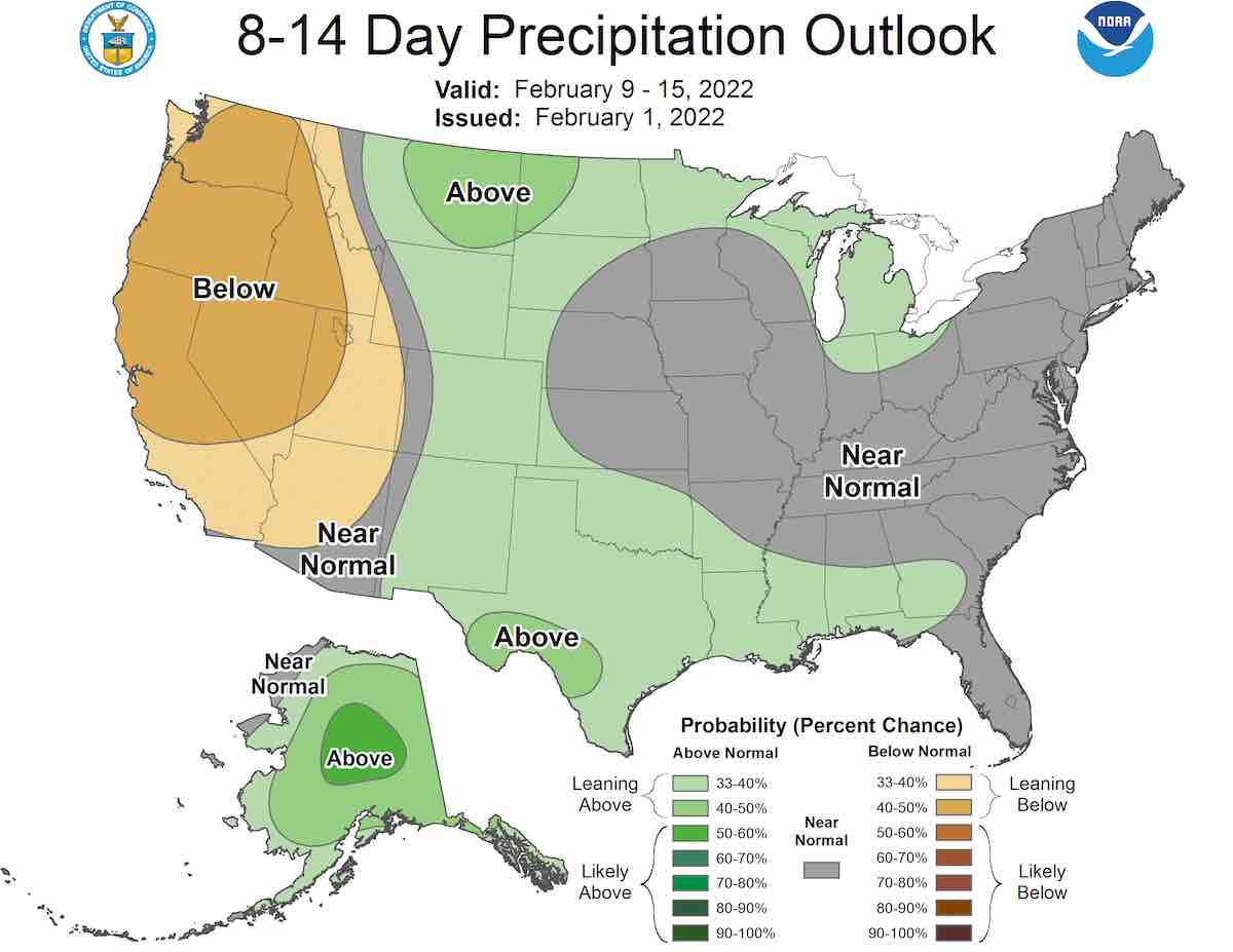
- Below-average precipitation for the western US
- Above-average precipitation for the Great Lakes, Great Plains region
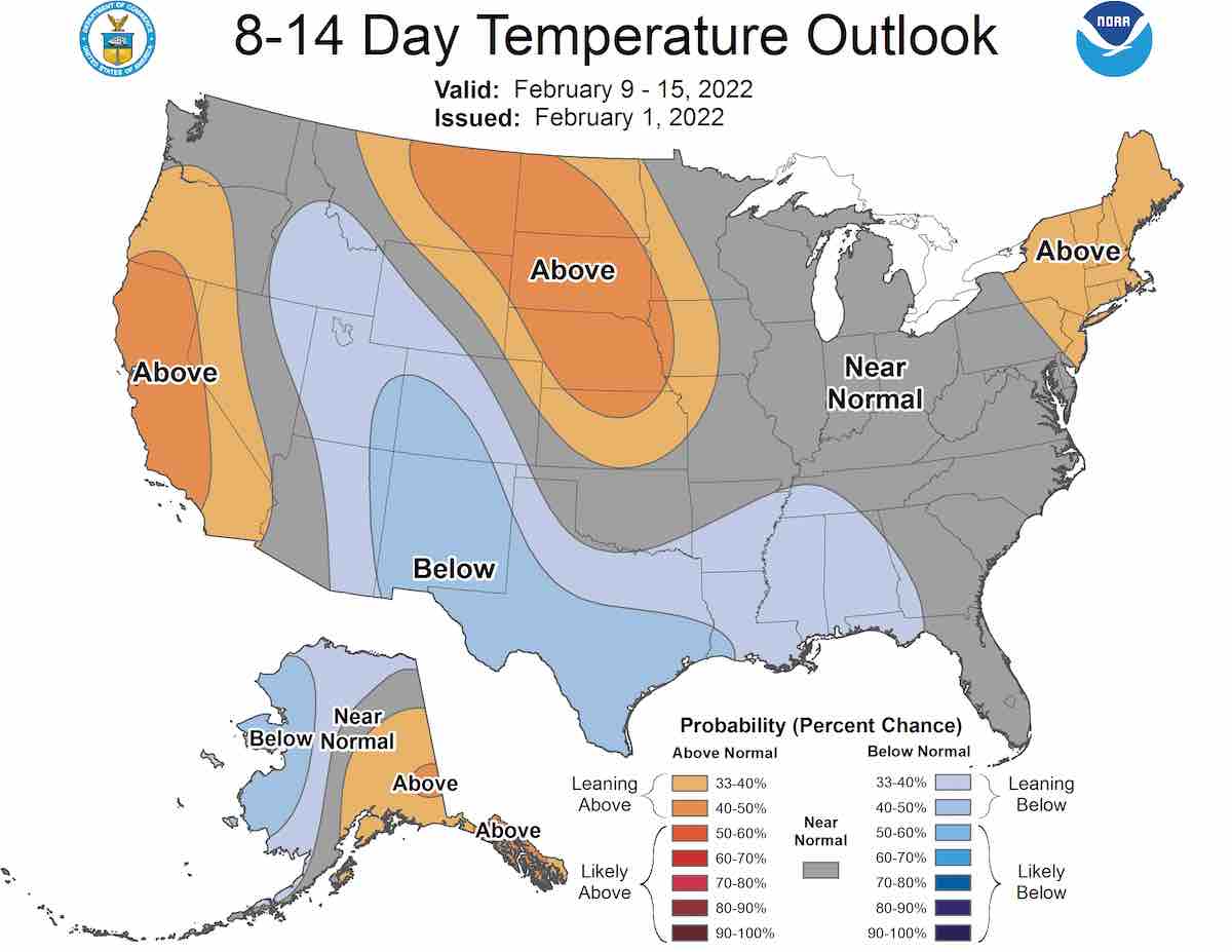
- Below-normal temperatures for the Central and Southern Rockies Mountains
- Above-normal temperatures for Alaska and the West Coast of North America
- Above-normal temperatures for the Eastern Seaboard
- A chance for a large scale pattern change during this period
The full discussion is below:
8-14 DAY OUTLOOK FOR FEB 09 – 15 2022
During the week-2 period, the overall 500-hPa flow pattern across western North America is likely to be dominated by very strong ridging predicted over the eastern North Pacific. This ridge is forecast to continue strengthening and to retrograde, leading to height rises for much of southern Alaska. With this strong Pacific ridge in place, downstream troughing is forecast to persist across much of the Southwest and Southern Plains. Farther to the east, a positive NAO is forecast to be a major driver of the flow pattern. Troughing and below-normal heights are forecast near the Davis Strait, with a broad area of predicted above normal heights stretching across the North Atlantic to the Eastern Seaboard.
Persistent troughing forecast over the southwestern and south-central CONUS leads to increased chances of below-normal temperatures for the Central and Southern Rockies, Southern Plains, and Lower Mississippi Valley. Above normal temperatures are likely for southeastern Alaska, as well as the West Coast, near the predicted ridge over the eastern North Pacific. Above normal temperature probabilities are slightly enhanced for parts of the Northern and Central Plains, due to the potential for downslope flow. Near to above normal temperatures are favored for the Eastern Seaboard, consistent with a moderating trend associated with a positive NAO. Conversely, below normal temperatures are favored for much of western and northern Alaska, associated with a trough forecast over the Bering Strait in the period.
As a mean trough is forecast across the Southwest and Southern Plains, above-normal precipitation is favored from the Great Plains eastward across the Gulf Coast and Lower Mississippi Valley. Near to above normal precipitation is slightly favored for the Great Lakes, associated with a mean trough forecast over east-central North America. Below normal precipitation is most likely across much of the western CONUS, associated with strong ridging forecast off the West Coast. An active pattern is likely to continue into week-2 across much of Alaska underneath enhanced southwesterly mid-level flow, leading to elevated probabilities of above normal precipitation for most of the state.
The official 8-14 day 500-hPa height blend consists of: 20% of Today’s 0z GFS Ensemble Mean centered on Day 11, 20% of Today’s 6z GFS Ensemble Mean centered on Day 11, 10% of Today’s GFS Superensemble Mean centered on Day 11, 20% of Today’s 0z European Ensemble Mean centered on Day 11, 20% of Yesterday’s 12z European Ensemble Mean centered on Day 10, and 10% of Today’s 0z Canadian Ensemble Mean centered on Day 11
FORECAST CONFIDENCE FOR THE 8-14 DAY PERIOD: Below Average, 2 out of 5, due to a potential large-scale pattern change during the period.