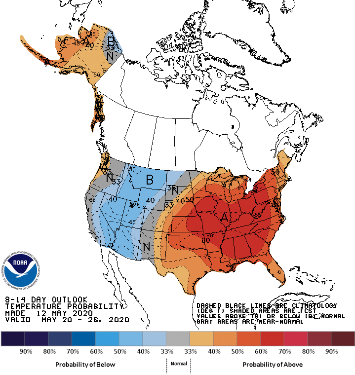
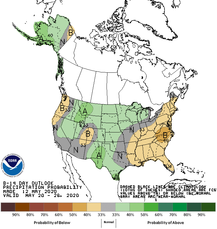
The NOAA just released their outlook for the end of May. After the warmer temperatures the last few weeks, much of the west can look forward to cooler conditions, whereas towards the east expect it to be much warmer than normal. The majority of western USA can expect precipitation to be at, or slightly below, average and the east is looking like being drier than usual.
Full forecast discussion below:
8-14 DAY OUTLOOK FOR MAY 20 - 26 2020

During the 8-14 day period, the model ensemble solutions predict a similar but
de-amplified 500-hPa circulation pattern relative to  the 6-10 day period with
a slight eastward progression. Meanwhile, a mean ridge and positive 500-hPa
height anomalies are favored over the eastern half of the CONUS. Troughing and
below normal 500-hPa geopotential heights are favored over parts of western
Mainland Alaska and the Aleutians. Ridging and above normal 500-hPa heights are
forecast over the North Pacific and Alaska Panhandle, and parts of the Pacific
Northwest.  A mean trough is forecast over most of the remainder of the western
CONUS.

Above normal temperatures are favored for most of Alaska and parts of the
Pacific Northwest, consistent with the consolidation forecast tool. Below
normal temperatures are likely over much of the western CONUS, due to forecast
troughing over the region. Subtropical ridging and above normal 500-hPa heights
favor above normal temperatures for much of the eastern and central CONUS.

Above normal precipitation is favored for much of Alaska, in association with
troughing over the Aleutians. Below normal precipitation is favored for parts
of the Pacific northwest and northern California, underneath forecast near to
above normal 500-hPa heights. Above normal precipitation is favored for parts
of the interior western CONUS eastward across the Northern Plains into the
Great Lakes region, in association with predicted mean troughing over the
western CONUS. Increased probabilities for above normal precipitation over most
of the Great Plains are consistent with the consolidation forecast tool. Below
normal precipitation is likely for most of the eastern CONUS, underneath
forecast above normal 500-hPa heights.

The official 8-14 day 500-hPa height blend consists of: 15% of Today's 6z GFS
Ensemble Mean centered on Day 11, 15% of Today's GFS Superensemble Mean
centered on Day 11, 10% of Today's operational 6z GFS centered on Day 11, 40%
of Today's 0z European Ensemble Mean centered on Day 11, and 20% of Today's 0z
Canadian Ensemble Mean centered on Day 11


FORECAST CONFIDENCE FOR THE 8-14 DAY PERIOD: Average, 3 out of 5, due to some
disagreement among models in the predicted 500-hPa circulation pattern over
North America, leading to uncertainty in the precipitation and temperature
fields.
One thought on “NOAA 8-14 Day Outlook: West Cooler and Wetter, East Hotter and Drier”