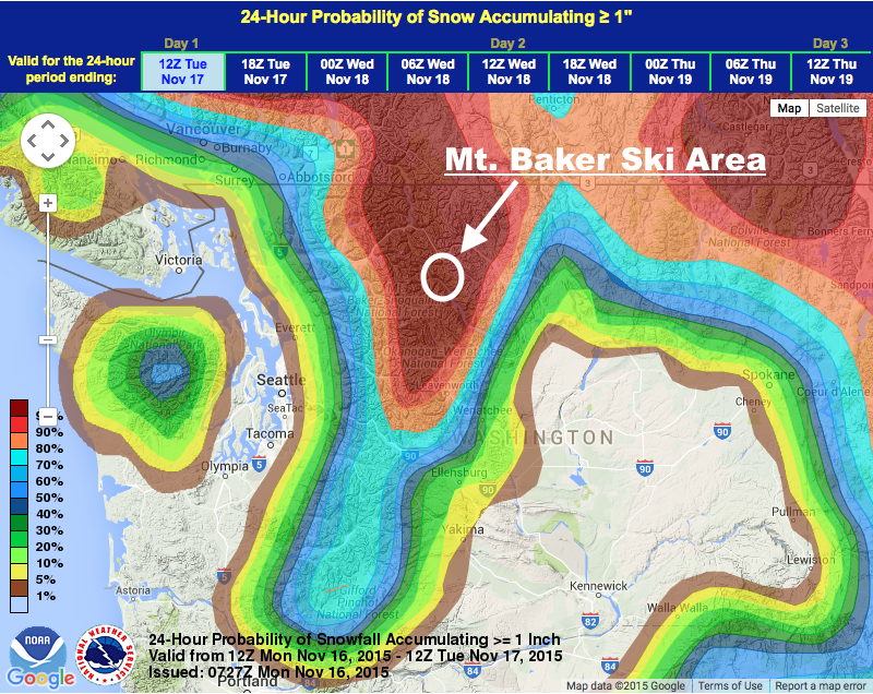
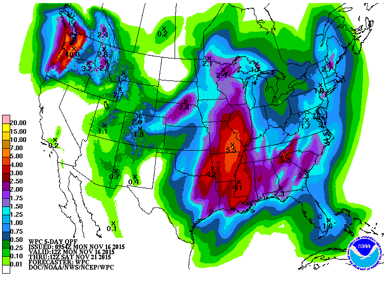
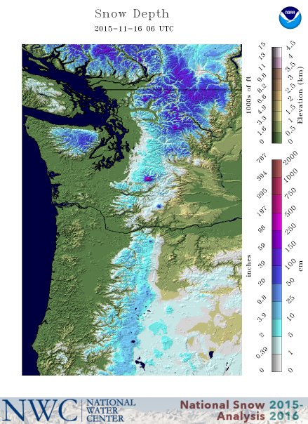
NOAA is forecasting another large storm to slam into Washington today dropping 1-2 feet of snow in the cascade mountains with up 25″ of snow at Mt. Baker ski area & up to 93″ of snow forecast on 10,781-foot Mt. Baker proper.
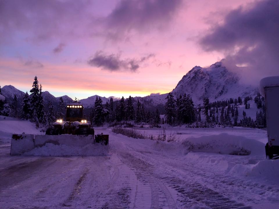
The powerful storm that just blew through Washington dropped 40″ of snow on Mt. Baker ski area in 72 hours leading Baker to announce its opening day for this Thursday.
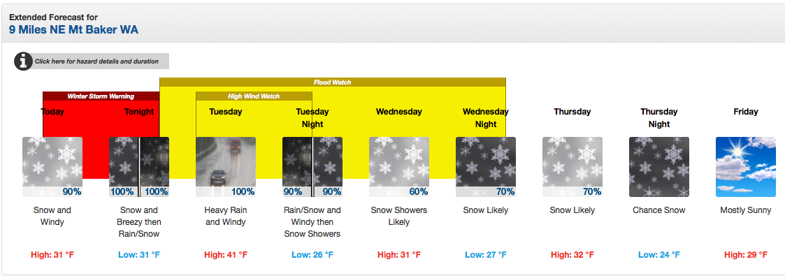
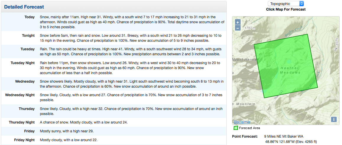
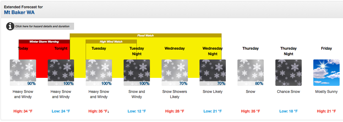
A Winter Storm Warning is in effect in Washington’s mountains from 10am today until 4am Tuesday.
NOAA is forecasting 12-24″ of snow for the Cascade mountains in Washington today – Tuesday with snowfall rates as high as 1-2 inches per hour tonight.
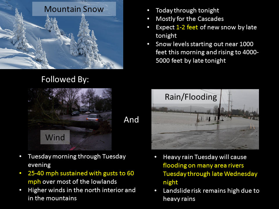
* ACCUMULATIONS...1 TO 2 FEET OF NEW SNOW IS LIKELY BY LATE
  TONIGHT. SNOWFALL RATES OF 1 TO 2 INCHES PER HOUR AT TIMES ARE LIKELY
  TONIGHT. - NOAA Seattle, WA today
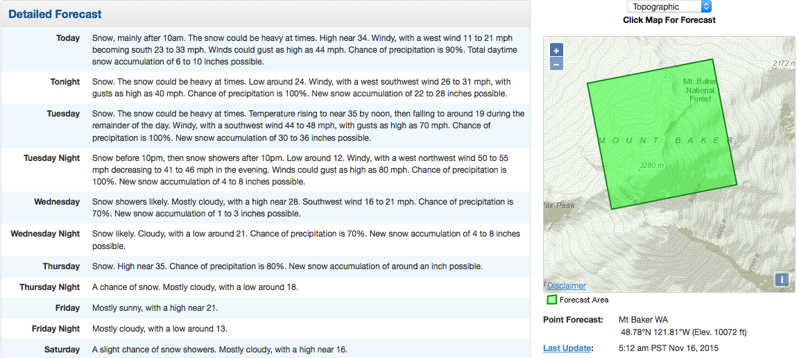
Snow levels will start out around 1,000-feet this morning before rising to 5,000-feet tonight.
* SNOW LEVEL...STARTING OUT NEAR 1000 FEET THIS MORNING...THEN
  RISING TO 4500 TO 5000 FEET BY LATE TONIGHT. - NOAA Seattle, WA today
Mt. Baker ski area is forecast to see 13-25″ of snow in the next 3 days along with some heavy rain on Tuesday morning. The good news is that Mt. Baker ski area is forecast to see 10-17″ of snow before the rain and 3-7″ of snow after the rain (see bottom of article for NOAA graphic).
NOAA is forecasting 10,781-foot Mt. Baker to see up to 93″ of snow in the next 3 days.
THE MOUNTAINS COULD RECEIVE 7 TO 10INCHES OF RAIN.
- NOAA Seattle, WA today
7-10 inches of rain on Mt. Baker (above snow line) would translate to 7-10 feet of snow…
***
There are no ski resorts currently open in Washington, but Mt. Baker will be opening on Thursday and we suspect that Crystal Mountain will be opening this week as well.
***
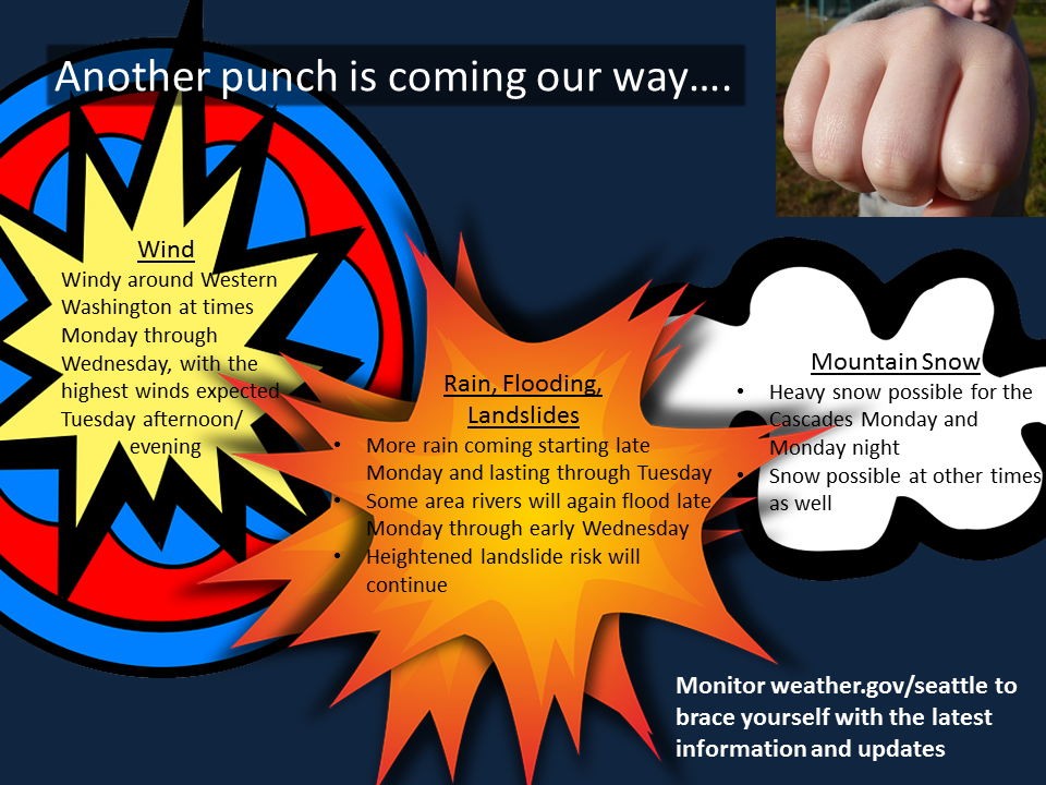
WINTER STORM WARNING for WASHINGTON:
URGENT - WINTER WEATHER MESSAGE
NATIONAL WEATHER SERVICE SEATTLE WA
445 AM PST MON NOV 16 2015

CASCADES OF WHATCOM AND SKAGIT COUNTIES-

...WINTER STORM WARNING REMAINS IN EFFECT FROM 10 AM THIS MORNING TO
4 AM PST TUESDAY...

* ACCUMULATIONS...1 TO 2 FEET OF NEW SNOW IS LIKELY BY LATE
  TONIGHT. SNOWFALL RATES OF 1 TO 2 INCHES AT TIMES ARE LIKELY
  TONIGHT.

* SOME AFFECTED LOCATIONS...MOUNT BAKER HIGHWAY.

* TIMING...SNOW WILL INCREASE IN INTENSITY THIS AFTERNOON AND
  PERSIST THROUGH MUCH OF TONIGHT BEFORE CHANGING OVER TO RAIN
  EARLY TUESDAY MORNING.

* SNOW LEVEL...STARTING OUT NEAR 1000 FEET THIS MORNING...THEN
  RISING TO 4500 TO 5000 FEET BY LATE TONIGHT.

* MAIN IMPACT...HAZARDOUS DRIVING CONDITIONS DUE TO HEAVY SNOW
  CAUSING POOR VISIBILITY AT TIMES.
***
MT BAKER SKI AREA SNOWFALL FORECAST: