“A potentially strong Atmospheric River will be taking aim at California this week. Heavy precipitation is expected especially for Southern CA and the Sierra Nevada. Please follow” – NOAA Sacramento, CA today
NOAA is forecasting an atmospheric river storm to impact California this week from Wednesday through Saturday.
Total snow accumulations of 1 TO 3 FEET LIKELY, WITH LOCAL AMOUNTS OF UP TO 4 FEET.
- NOAA Reno, NV today for Mono County (Mammoth)
This storm looks to be zeroing in on Mammoth Mountain, CA where up to 5-feet of snow is forecast and a Winter Storm Watch has been issued.
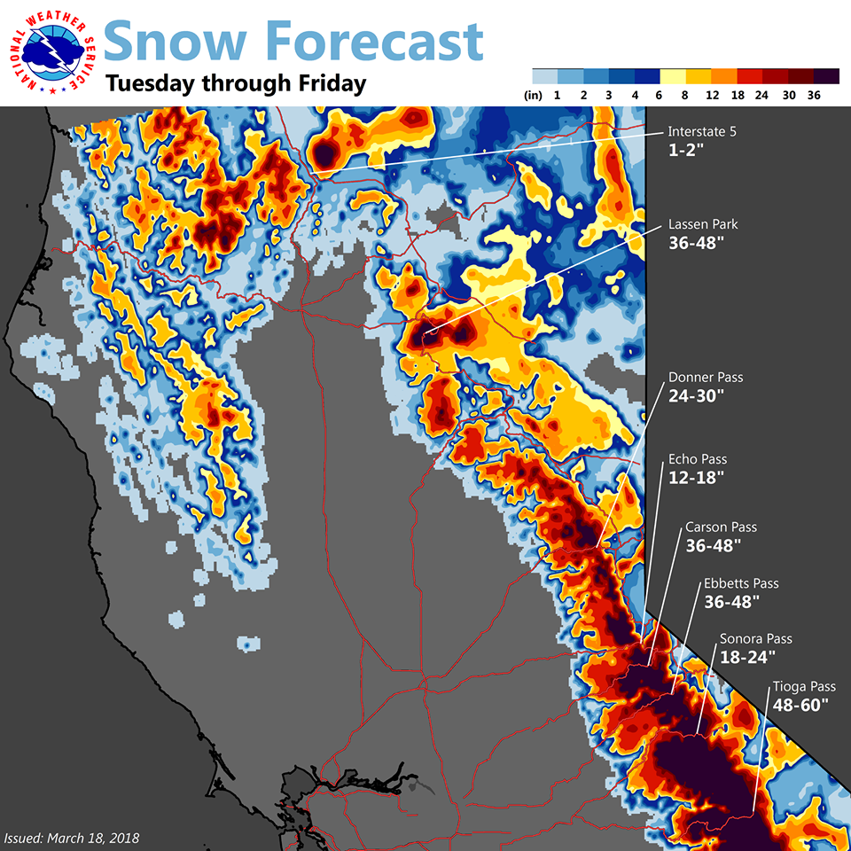
“A Winter Storm Watch is issued for the Sierra Nevada above 8000 feet from Yosemite N.P to the Kern County line. Snow amounts of 2 to 3 feet with isolated areas of 4 feet is expected. Blowing and drifting snow and local whiteout conditions possible. The heaviest snow is likely from Wednesday afternoon into Thursday morning. Hikers and campers over the high Sierra should be prepared for hazardous wintry weather. A Winter Storm Watch means there is potential for significant snow, sleet or ice accumulations that may impact travel. Continue to monitor the latest forecasts.” – NOAA Hanford, CA today
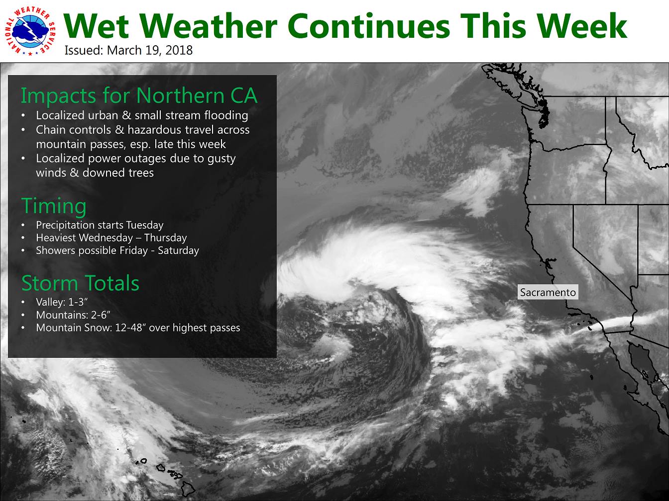
“We have a wet week ahead! Wondering when it’s going to start? Here’s a timing loop to show the current thinking (below). Precipitation gradually spreads in Tuesday. Heaviest precipitation for our area is expected Wednesday night through Thursday. Snow levels start high, around pass levels, but are expected to rapidly drop Thursday night, reaching below 4000 feet by early Friday.” – NOAA Sacramento, CA today
The storm is forecast to come in warm with snow levels as high as 8,000′ on Wednesday.
Snow levels drop to as low as 4,000′ by Friday morning.
This should be another wild weather week in Tahoe that might make “Miracle March” a reality.
Squaw Alpine, CA has already seen 191″ of snow thus far in the month of March.
“Miracle March” was coined in 1991 when Lake Tahoe, CA ski resorts saw up to 240″ of snow in month of March.
“Miracle March” 2018 just might be even a touch bigger than 1991 if all goes our way…
Fingers crossed!
We are headed home from Alaska to hit this one…
FORECAST DISCUSSION:
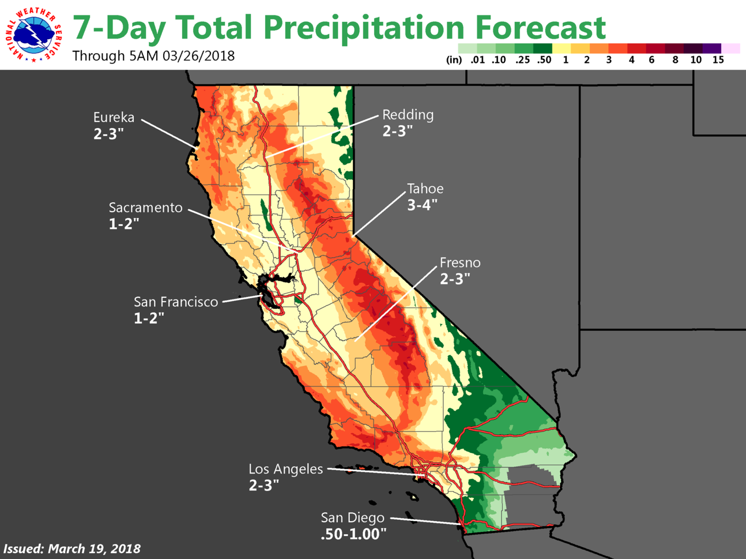
Wednesday and Thursday (AR Storm):

  Latest trends have shown a distinct period of a warm storm (higher
  snow levels) Wed-Thu followed by colder and shorter duration
  systems heading into the next weekend. Overall, looking for a
  roughly 24-36 hour period of precipitation from Wednesday through
  Thursday evening with a peak precipitation window from Thursday
  morning into the early evening.

  Snow levels look to start around the 7,500-8,000` vicinity Wednesday
  into early Thursday morning from the Tahoe Basin and extending south
  through the Sierra in Mono County. Snow levels will begin to fall to
  6,500 to 7,000 by Thursday afternoon from Tahoe to Mono County before
  dropping below 6,000` by Thursday evening.

  The main moisture plume looks to be focused mainly from Mono County
  southward. Have increased precipitation amounts with total QPF
  amounts Wednesday through Thursday along the Sierra crest in the 2-
  3" range across the Tahoe Basin and 3-4" possible across the crest
  in southern Mono County. Spillover rainfall is most likely on
  Thursday for western Nevada with 0.25"-0.50" possible by Thursday
  evening.

  Gusty winds will also accompany this storm with ridge gusts reaching
  over 80 mph by Wednesday and continuing into Thursday. Valleys could
  also see wind gusts in the 40-50 mph range particularly through the
  highway 395/I580 corridor. Fuentes
Winter Storm Watch for Mammoth, CA:
URGENT - WINTER WEATHER MESSAGE
National Weather Service Hanford CA
945 AM PDT Mon Mar 19 2018

Sierra Nevada from Yosemite to Kings Canyon-
Tulare County Mountains-
Including the cities of Camp Nelson, Giant Forest, Lodgepole,
and Johnsondale

...WINTER STORM WATCH IN EFFECT ABOVE 8000 FEET FROM TUESDAY
EVENING THROUGH THURSDAY EVENING...

* WHAT...Heavy snow possible. Total snow accumulations of 1 TO 3
  FEET LIKELY, WITH LOCAL AMOUNTS OF UP TO 4 FEET. The heaviest
  snow is likely from Wednesday afternoon into Thursday morning.

* WHERE...Sierra Nevada from Yosemite National Park to the Kern
  County line.

* WHEN...From Tuesday evening through Thursday evening.

* ADDITIONAL DETAILS...Blowing and drifting snow and local
  whiteout conditions possible. Hikers and campers over the high
  Sierra should be prepared for hazardous wintry weather.