NOAA is stating today that the atmospheric river forecast for the West Coast this week will impact California. Snow and Rain should start in California on Friday.
Snow levels will be 8,000-9,000′ with this storm.
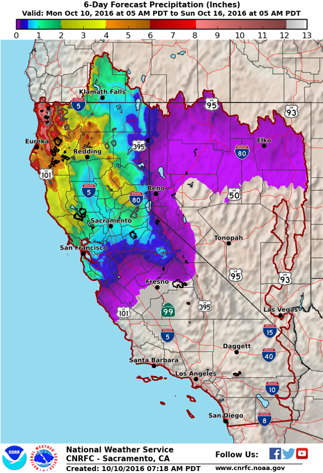
“Conditions are expected to turn favorable for moderate to heavy precipitation later this week, especially for areas north of Interstate 80 and near/west of the Sierra Nevada crest. Heaviest amounts are forecast along the north coast near Cape Mendocino northward to the Smith River basin with 5 to 12 inches possible by Sunday morning. More precipitation is anticipated Sunday as well… but not included in this graphic.” – NOAA, today

14,172′ Mt. Shasta, CA looks like it’ll get buried by this storm. Snow levels are forecast to drop as low as 6,000-feet for Mt. Shasta with 5-7″ of precipitation. That could mean 5-7 feet of snow up on Shasta…
Preliminary expected total precipitation
amounts from Thursday morning to sunrise Monday morning are 10 to
15 inches in the Brookings area and the Curry Coastal Mountains,
5-10 inches in other portions of the Coastal Counties, 3 to 5
inches in much of Douglas County and the Cascades and Siskiyous, 5
to 7 inches in the Mount Shasta area, 2 to 3 inches in the usually
drier Bear Creek portion of the Rogue Valley and Central and
Northern Shasta Valley, and 1 to 3 inches on the East Side.
- NOAA Medford, OR today
Snow levels look to be above 8kft for the bulk of this precipitation event, but could dip to between 6kft and 7kft in heavier bursts of precipitation and on the tail end of individual frontal systems. - NOAA Medford, OR today

Damaging winds will be associated with this storm in Tahoe.
“We are forecasting a significant change in the weather late this week and into the weekend. Confidence is increasing for a high wind event Friday with strong winds continuing Saturday and Sunday. Damaging winds will be possible along with impacts to travel for high profile vehicles, aviation, and high fire danger. This system will also provide chances for locally heavy rainfall in portions of the northern Sierra and northeast California over the weekend and into early next week.
BOTTOM LINE – Forecast details are likely to change over the next several days, so if you have plans late this week into the weekend please keep an eye on the forecast!” – NOAA Reno, NV today

Atmospheric river will be strong for the Pacific Northwest and moderate for California.
The forecast is still on track for a wet and windy weekend as a
strong jet ushers an atmospheric river into the Pacific Northwest.
This would be considered a strong atmospheric river for the Pacific
Northwest coast and moderate for the northern Sierra and northeast
California. The main forecast changes include increasing wind
speeds, especially on Friday, and raising precipitation chances
Friday and Sunday into Monday, especially in the northern Sierra and
northeast California. - NOAA Reno, NV today

Snow levels will be 8,000-9,000′ in California.
SNOW LEVELS: Snow levels will be high, as is typical with
atmospheric river events. Generally speaking they will be around
9000 feet or above, but may drop as low as 8000 feet in the heavier
precipitation in the northern Sierra and northeast California. This
means that the majority of Sierra passes will only see rain. Snow
levels look to lower behind the upper trough passage, but this will
also correspond with decreasing precipitation chances.
- NOAA Reno, NV today


thing is , the sobaranes fire has torched about half of big sur. the rains might cancel out the fire finally but floods will be around. DONT BURN .. and don’t leave a campfire turned on !!!