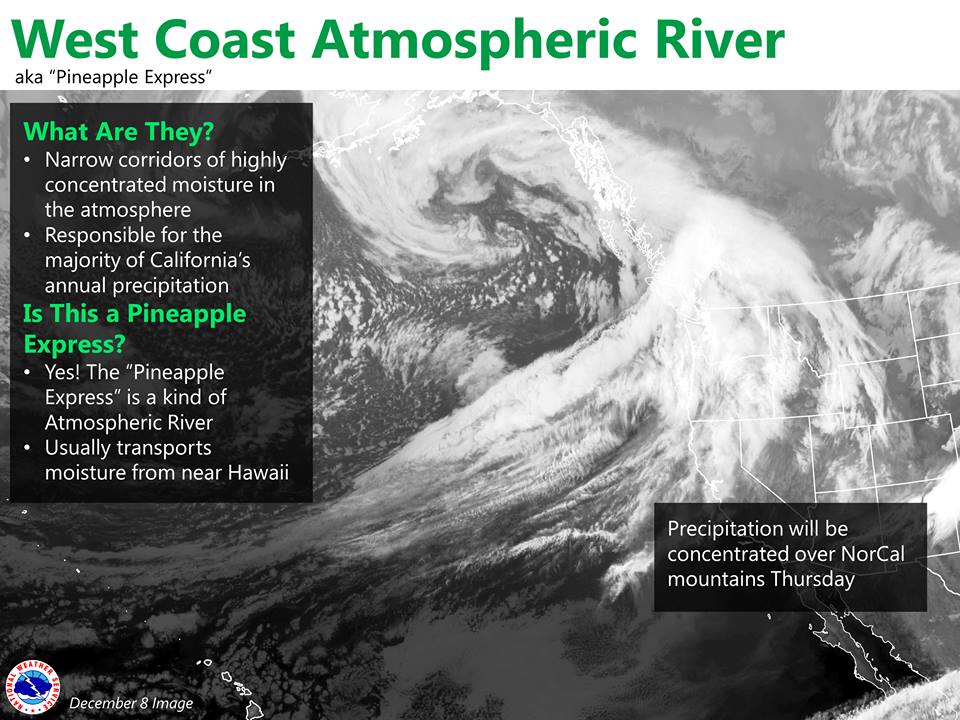
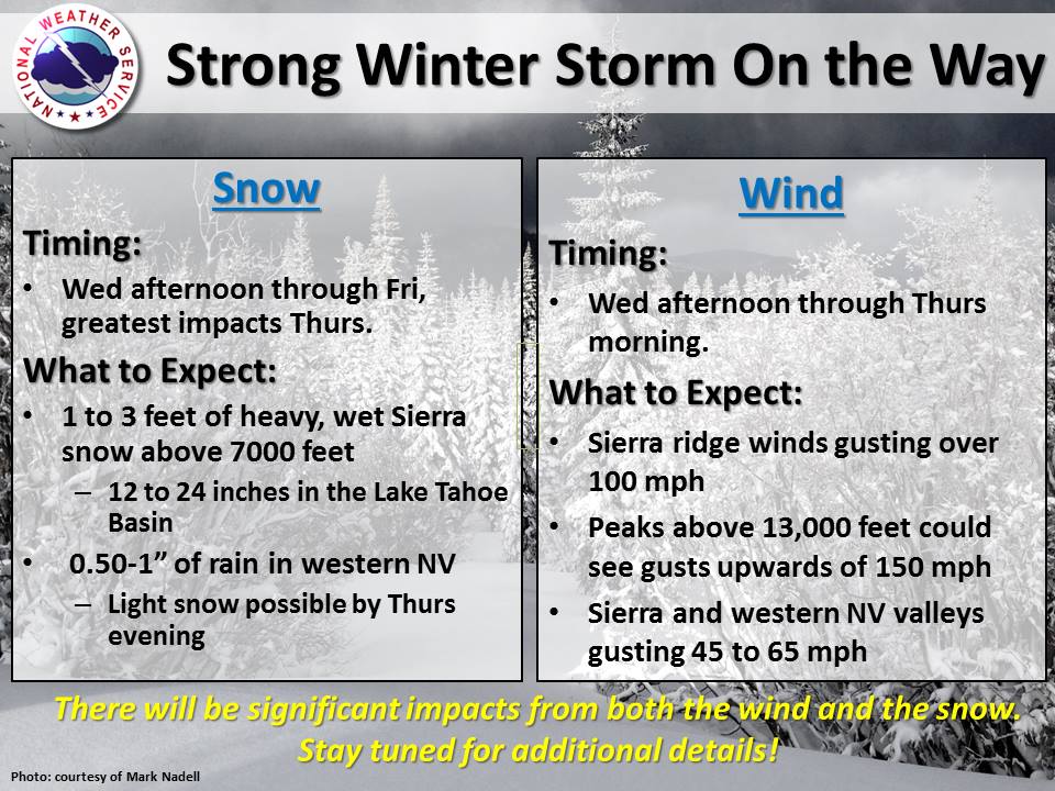
NOAA is tracking an Atmospheric River storm forecast to slam into California tomorrow night. This storm is forecast to drop 1-3 Feet of Snow above 7,000-feet in only 24 hours. Snow levels will start high, around 8,500′ before dropping down to 5,500′ on Thursday. Winds will be 100-125mph on Sierra ridges. A Winter Storm Watch has been issued for the Sierra.
OVERALL SNOW POTENTIAL REMAINS SIMILAR WITH 1-3 FEET IN THE SIERRA
NEAR TAHOE ABOVE 7000 FEET, 1-2 FEET IN THE TAHOE BASIN AND NEAR THE
CREST IN MONO COUNTY. - NOAA Reno, NV today
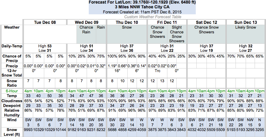
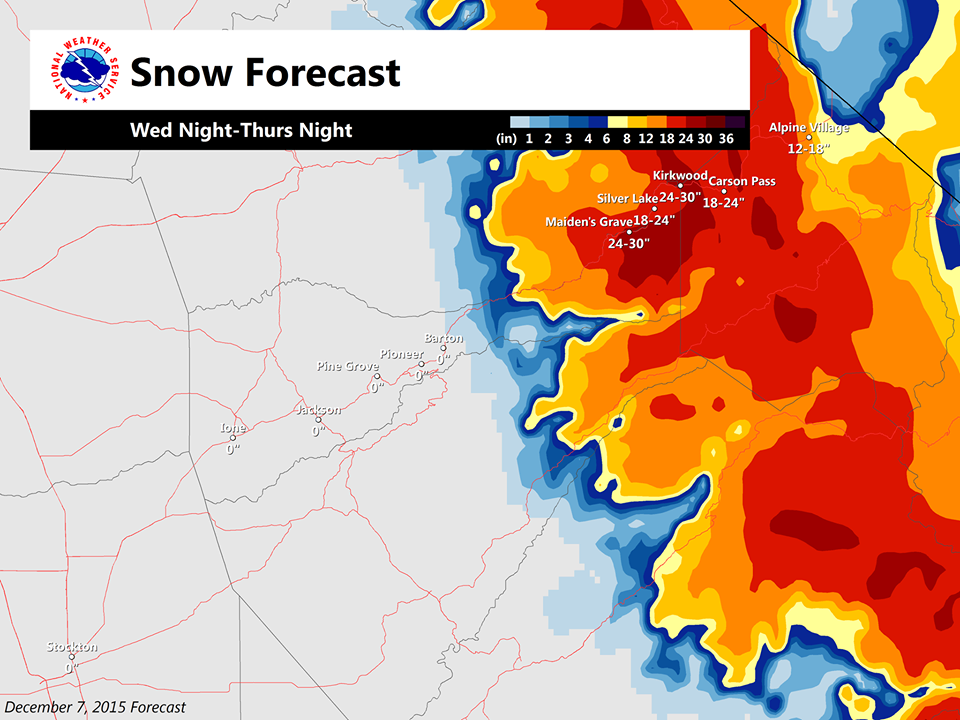
Local NOAA Snow Forecast:
- 24-30″ for Kirkwood
- 18-24″ for West Lake Tahoe ski resorts
- 12-18″ for East Lake Tahoe ski resorts
- 12-24″ for Mammoth
- 12-24″ for Yosemite N.P.
- 6-12″ for Kings Canyon N.P.
***
Another large but colder storm with big snow potential will hit California on Sunday:
BY SUNDAY, THE MAIN COLD FRONT AND MOISTURE PLUME REACHES THE SIERRA
WITH ANOTHER ROUND OF VERY HEAVY SIERRA SNOW LIKELY. THIS STORM
LOOKS COLDER THAN THE THURSDAY STORM WITH HIGHER SNOW RATIOS AND
SNOW LEVELS DROPPING TO ALL VALLEY FLOORS ON SUNDAY. - NOAA Reno, NV today
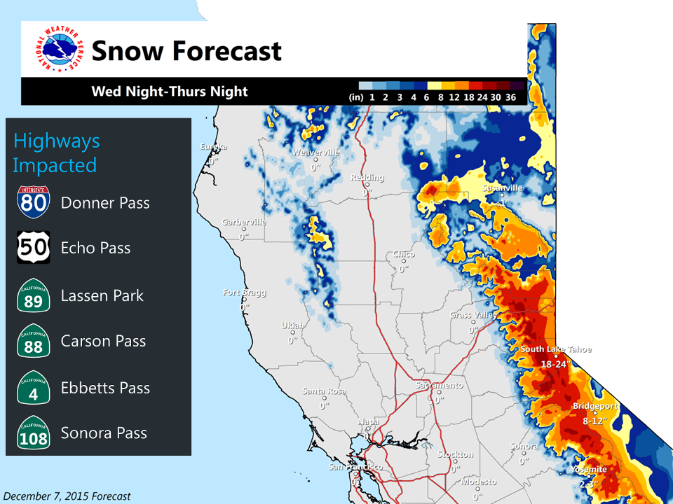
NOAA is forecasting 12-24″ of snow at Lake Tahoe level and 1-3 Feet of snow above 7,000-feet. This all forecast to fall within 24 hours starting Wednesday night when Winter Storm Watch will be in effect.
* SNOW ACCUMULATIONS: AROUND 1 TO 3 FEET ABOVE 7000 FEET WITH
  LOCALLY HIGHER AMOUNTS ALONG THE SIERRA CREST. 12 TO 24 INCHES
  POSSIBLE AT LAKE LEVEL WITH THE HIGHEST AMOUNTS ALONG AND WEST
  OF HIGHWAY 89. - NOAA Reno, NV today
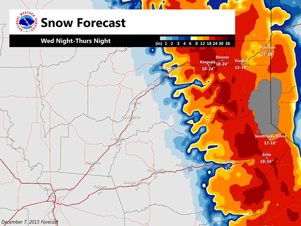
Snow levels will start high, around 8,000-feet before dropping to 5,500-feet by Thursday afternoon.
* SNOW LEVELS: 8000 TO 8500 FEET WEDNESDAY NIGHT...THEN FALLING TO
  BELOW 5500 FEET BY EARLY THURSDAY AFTERNOON. - NOAA Reno, NV today
Winds will be ripping with this storm with gusts over 100mph on Sierra ridgetops. This storm very well may shut down ski resorts in Tahoe on Thursday just as the last windy storm did on Sunday.
SIERRA RIDGE GUSTS BETWEEN 100-125 MPH ARE LIKELY, WITH GUSTS NEAR 150 MPH
POSSIBLE FOR THE HIGHEST PEAKS OVER 13,000 FEET. - NOAA Reno, NV today
This will be a helluva storm with big snow totals and we’ll be getting another storm that is forecast to be colder and have similar snow levels on Sunday. Life is looking good in California for the next week.
Lets all be smart about backcountry travel and stay safe out there during this big storm cycle. Avalanche conditions will we dangerous for the next week in the backcountry. Check the advisory:
Sierra Avalanche Center
Eastern Sierra Avalanche Center
WINTER STORM WATCH:
URGENT - WINTER WEATHER MESSAGE
NATIONAL WEATHER SERVICE RENO NV
341 AM PST TUE DEC 8 2015

CAZ072-NVZ002-090000-
/O.CON.KREV.WS.A.0002.151210T0800Z-151211T1200Z/
GREATER LAKE TAHOE AREA-
INCLUDING THE CITIES OF...SOUTH LAKE TAHOE...TAHOE CITY...
TRUCKEE...MARKLEEVILLE...GLENBROOK...INCLINE VILLAGE
341 AM PST TUE DEC 8 2015

...WINTER STORM WATCH REMAINS IN EFFECT FROM LATE WEDNESDAY NIGHT
THROUGH LATE THURSDAY NIGHT...

A WINTER STORM WATCH REMAINS IN EFFECT FROM LATE WEDNESDAY NIGHT
THROUGH LATE THURSDAY NIGHT.

* TIMING: SNOW WILL MOVE INTO THE LAKE TAHOE BASIN LATE
  WEDNESDAY NIGHT WITH HEAVY SNOWFALL BY THURSDAY MORNING. SNOW
  WILL DECREASE BY THURSDAY EVENING WITH SNOW SHOWERS
  LINGERING INTO FRIDAY MORNING.

* SNOW ACCUMULATIONS: AROUND 1 TO 3 FEET ABOVE 7000 FEET WITH
  LOCALLY HIGHER AMOUNTS ALONG THE SIERRA CREST. 12 TO 24 INCHES
  POSSIBLE AT LAKE LEVEL WITH THE HIGHEST AMOUNTS ALONG AND WEST
  OF HIGHWAY 89.

* WINDS: STRONG WINDS ARE EXPECTED WEDNESDAY NIGHT INTO THURSDAY
  MORNING. SOUTHWEST 30 TO 45 MPH WITH GUSTS UP TO 65 MPH. RIDGE
  GUSTS UP TO 125 MPH. DAMAGE TO TREES IS POSSIBLE.

* SNOW LEVELS: 8000 TO 8500 FEET WEDNESDAY NIGHT...THEN FALLING TO
  BELOW 5500 FEET BY EARLY THURSDAY AFTERNOON.

* IMPACTS: SNOW AND BLOWING SNOW WITH WHITEOUT CONDITIONS AND
  ICY ROADS. SNOWFALL RATES WILL EXCEED PLOWING CAPABILITIES AT
  TIMES. THIS INCLUDES INTERSTATE 80...HIGHWAY 50...CALIFORNIA
  HIGHWAYS 88...89...267 AND NEVADA HIGHWAYS 28...207 AND 431.
  SIGNIFICANT DELAYS AND DANGEROUS WINTER WEATHER CONDITIONS
  POSSIBLE FOR BACK COUNTRY ACTIVITIES.
Very cool first time visiting your site its like what the surfers use to predict swells. Say I’m sure you know this site if not checkout windyty.com
Great site!!
And let the roadway closure stress BEGIN!