
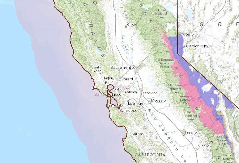
The storm hitting California today and tomorrow is going to be stronger than previously forecast, according to NOAA. The Winter Storm Watch on the west slope & crest of the Sierra Nevada has been upgraded to a Winter Storm Warning. There were no advisories on the east slope of the Sierra Nevada nor the Tahoe Basin as of yesterday, but today there’s a Winter Weather Advisory for the east slope of the Sierra and the Tahoe Basin.
Both the Winter Storm Warning & Winter Weather Advisory are in effect from 10pm tonight until 10pm Monday.
UPGRADED SNOW TOTALS:
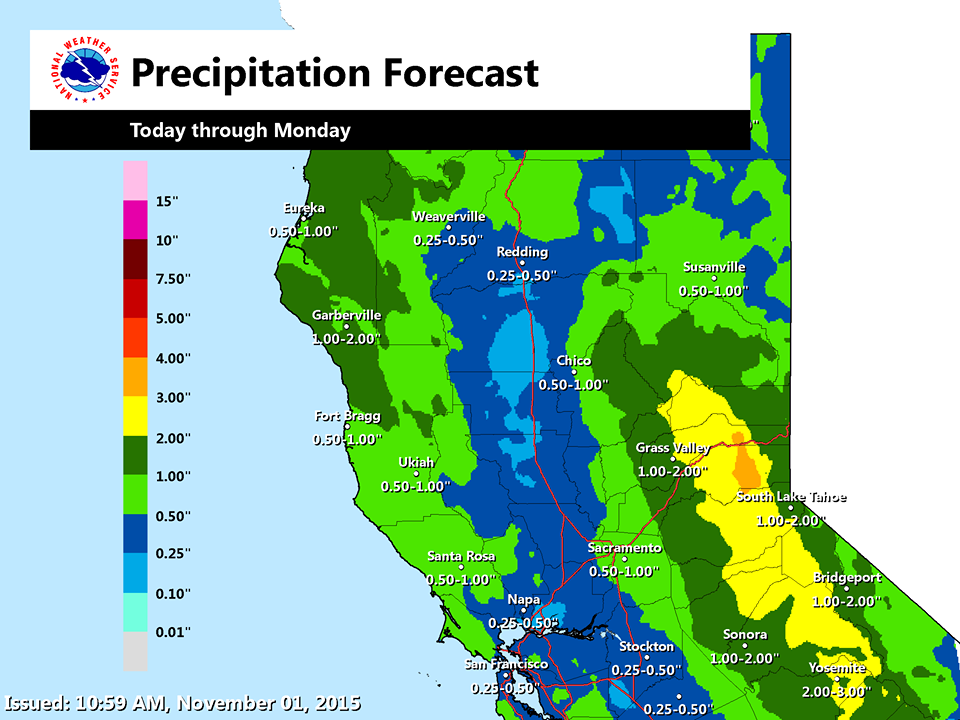
Lake Tahoe = up to 2-Feet of Snow
* SNOW ACCUMULATIONS: 1 FOOT OR MORE ABOVE 8500 FEET WITH LOCALIZED
AMOUNTS AROUND 2 FEET. 3 TO 5 INCHES AROUND 7000FEET INCLUDING
ECHO AND DONNER SUMMITS. UP TO 2 INCHES AT LAKELEVEL. - NOAA Reno, NV today
Mammoth = up to 2-Feet of Snow
* SNOW ACCUMULATIONS: 3 TO 5 INCHES ABOVE 7000 FEET WITH
1 TO 2FEET POSSIBLE NEAR THE SIERRA CREST ABOVE 9000 FEET.
- NOAA Hanford, CA today

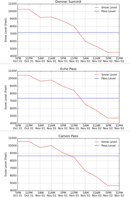
SNOW LEVELS:
Snow levels will generally start out around 9,000-feet with this storm before crashing down to 6,000-feet or lower on Monday morning.
Snow levels will drop to highway pass levels around 11pm tonight.
Tioga Pass is scheduled to close today at 4pm and may stay closed for the season. Sonora Pass will also most likely close today.
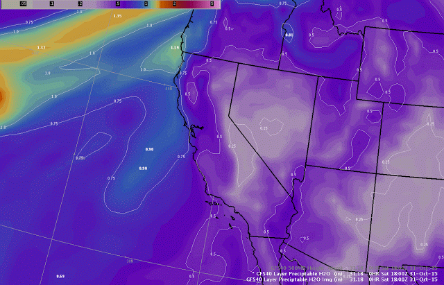
ATMOSPHERIC RIVER:
What’s causing this impactful winter storm is an atmospheric river that is dropping down into California from the Pacific Northwest (where 162″ of snow was forecast for Mt. Rainier, WA this weekend).
This atmospheric river will be hitting California today and tomorrow.
WINTER WEATHER ADVISORY for
EAST SLOPE of SIERRA and TAHOE BASIN:
URGENT - WINTER WEATHER MESSAGE
NATIONAL WEATHER SERVICE RENO NV
258 AM PST SUN NOV 1 2015

GREATER LAKE TAHOE AREA-
INCLUDING THE CITIES OF...SOUTH LAKE TAHOE...TAHOE CITY...
TRUCKEE...MARKLEEVILLE...GLENBROOK...INCLINE VILLAGE

...WINTER WEATHER ADVISORY REMAINS IN EFFECT FROM 10 PM THIS
EVENING TO 4 PM PST MONDAY...

* TIMING: SUNDAY EVENING INTO MONDAY AFTERNOON.

* SNOW ACCUMULATIONS: 1 FOOT OR MORE ABOVE 8500 FEET WITH
  LOCALIZED AMOUNTS AROUND 2 FEET. 3 TO 5 INCHES AROUND 7000
  FEET INCLUDING ECHO AND DONNER SUMMITS. UP TO 2 INCHES AT LAKE
  LEVEL.

* SNOW LEVELS: REMAINING ABOVE 8000 FEET THROUGH MIDNIGHT
  SUNDAY NIGHT THEN FALLING TO LAKE LEVEL MONDAY MORNING.

* IMPACTS: SNOW OVER THE SIERRA PASSES WILL CREATE HAZARDOUS
  WINTER DRIVING CONDITIONS. THE WORST CONDITIONS ARE EXPECTED
  OVER MT. ROSE AND CARSON PASSES SUNDAY NIGHT INTO MONDAY.
  ECHO AND DONNER SUMMITS WILL SEE SLICK DRIVING CONDITIONS
  MONDAY MORNING.
WINTER STORM WARNING for
WEST SLOPE of SIERRA & SIERRA CREST:
URGENT - WINTER WEATHER MESSAGE
NATIONAL WEATHER SERVICE HANFORD CA
325 AM PST SUN NOV 1 2015

INCLUDING THE CITIES OF...SHAVER LAKE...YOSEMITE VALLEY

...WINTER STORM WARNING IN EFFECT FROM 10 PM THIS EVENING TO
10 PM PST MONDAY...

THE NATIONAL WEATHER SERVICE IN HANFORD HAS ISSUED A WINTER STORM
WARNING FOR HEAVY SNOW...WHICH IS IN EFFECT FROM 10 PM THIS
EVENING TO 10 PM PST MONDAY. THE WINTER STORM WATCH IS NO LONGER
IN EFFECT.

* HAZARD TYPES...HEAVY SNOW.

* ACCUMULATIONS...8 TO 19 INCHES ABOVE 7000 FEET.

* TIMING...SNOW WILL BEGIN LATE SUNDAY EVENING. THE HEAVIEST
  SNOWFALL IS EXPECTED AFTER MIDNIGHT MONDAY THROUGH MID MORNING.
  SNOW LEVELS WILL BE ABOVE 9000 FEET SUNDAY EVENING LOWERING TO
  NEAR 7000 FEET BY LATE MONDAY MORNING.

* IMPACTS...SLICK...SNOW COVERED ROADS AND WINTER DRIVING
  CONDITIONS...POSSIBLE ROAD CLOSURES...BLOWING AND DRIFTING SNOW
  ACCOMPANIED BY WIND CHILL TEMPERATURES AS LOW AS THE TEENS BY
  MONDAY EVENING.
3 thoughts on “NOAA: California Storm Upgraded | Up to 2-FEET of Snow Forecast Today & Tomorrow”